Think the Press, from tpv is trended stronger,better position and thats caused the trends today. Definitely pushed down storm track. Same trend we caught a couple of weeks ago.
-
Hello, please take a minute to check out our awesome content, contributed by the wonderful members of our community. We hope you'll add your own thoughts and opinions by making a free account!
You are using an out of date browser. It may not display this or other websites correctly.
You should upgrade or use an alternative browser.
You should upgrade or use an alternative browser.
Wintry Feb 17-19 Smastsmasher Snow/Ice
- Thread starter SD
- Start date
iGRXY
Member
He screwed the pooch on the last one bad so I’m taking what he says with a grain of salt.Chris justice just did a Facebook live. He doesn’t see upstate sc getting much outside the extreme northern part close to nc border. Cold rain for most according to him
Sent from my iPhone using Tapatalk
RDUHeatIsland
Member
00z RGEM came through with our daily dose of model candy. It had ZR in the Triad for almost 30 hours, then had backside snow for NE NC. I'll take some of whatever it's smoking.


Apparently all the models have been toking on its smoke. Cause they all come full circle to its soloution.00z RGEM came through with our daily dose of model candy. It had ZR in the Triad for almost 30 hours, then had backside snow for NE NC. I'll take some of whatever it's smoking.
View attachment 75738
View attachment 75739
Run isn't done on tidbits but you can see why it flipped parts of NC to snow toward the end of it's run with this H5 look about half way through the run00z RGEM came through with our daily dose of model candy. It had ZR in the Triad for almost 30 hours, then had backside snow for NE NC. I'll take some of whatever it's smoking.
View attachment 75738
View attachment 75739

Stormlover
Member
rgem 
I’ve slowly been seeing this trend on some models .. some back side snow as the low has drifted much farther south and it almost looks like we get strong of lower pressure just giving us waves of precip until eventually that warm nose disappears00z RGEM came through with our daily dose of model candy. It had ZR in the Triad for almost 30 hours, then had backside snow for NE NC. I'll take some of whatever it's smoking.
View attachment 75738
View attachment 75739
Stormlover
Member
gfs is a monster 
Brent
Member
This snow on top of snow thing is insane
Nomanslandva
Member
Agree, I have seen hints of it too. Not sure if it potentially leads to backside snow or just prolonged ice, but waves at the end of the event could prolong things.I’ve slowly been seeing this trend on some models .. some back side snow as the low has drifted much farther south and it almost looks like we get strong of lower pressure just giving us waves of precip until eventually that warm nose disappears
Well I know what King Kong has taught us ... those SSW events are no joke and more than likely if u couple with a negative NAO it will produce some type of winter precip for the south and East ... this time no one is left unscathed ... except Florida I guess
Did get the brief 10 minute burst of mood flakes here as well. It dusted up the roads again before shutting off.
*Now* it's dry slot city for real, lol
*Now* it's dry slot city for real, lol
Dewpoint Dan
Member
I'm beginning to get worried you won't get 4-6" like I thought you would.Did get the brief 10 minute burst of mood flakes here as well. It dusted up the roads again before shutting off.
*Now* it's dry slot city for real, lol
And SOUTH CAROLINAWell I know what King Kong has taught us ... those SSW events are no joke and more than likely if u couple with a negative NAO it will produce some type of winter precip for the south and East ... this time no one is left unscathed ... except Florida I guess
Brent
Member
I'm beginning to get worried you won't get 4-6" like I thought you would.
The forecast for Dallas has been more like 2-4 at best but honestly the main event is still a couple hours away the hi res models show it backbuilding into the daytime hours
The stuff around Brownwood is what to watch that's supposed to blossom towards the metroplex
iGRXY
Member
that's getting to close to me back th f upAnd it's still going. Wtf. View attachment 75723
Well we know how freezing rain is a self limiting process thank god for that or this would have been a real ---- show ... oh wait. .... a stiff NE wind to keep the air cold and dry .... *gulps*

I'm beginning to get worried you won't get 4-6" like I thought you would.
I mean, it's still early. The snow wasn't really expected until after midnight.
We'll just have to watch radar trends as the night progresses. If it fills in faster, then the chances of several inches goes up.
HRRR is holding steadfast with 3-5", but it's an outlier. Hopefully it pulls a coup, lol.
Stephenb888
Member
This is gonna be nothing but cold rain in upstate sc (except maybe extreme northern) accept it and enjoy.
Stormlover
Member
One TV met here in town said off the record that this could be a level 10 storm for a few hours or more. The kind it gets bad so fast some people get stuck, and if you are out somewhere working, etc, you might not get home. It looks to hit late rush hour too.
Brent
Member
I mean, it's still early. The snow wasn't really expected until after midnight.
We'll just have to watch radar trends as the night progresses. If it fills in faster, then the chances of several inches goes up.
HRRR is holding steadfast with 3-5", but it's an outlier. Hopefully it pulls a coup, lol.
I'm wondering how we'll get an accurate measurement when we still have a solid snow cover tbh ? just filling in the footprints maybe to get an idea? ?
Never expected to have this problem lol
I'm wondering how we'll get an accurate measurement when we still have a solid snow cover tbh ? just filling in the footprints maybe to get an idea? ?
Up north, what the NWS observers do is put out plywood that they can clear between snowfalls.
VegasEagle
Member
Will it not change over to rain later that night?One TV met here in town said off the record that this could be a level 10 storm for a few hours or more. The kind it gets bad so fast some people get stuck, and if you are out somewhere working, etc, you might not get home. It looks to hit late rush hour too.
iGRXY
Member
WrongThis is gonna be nothing but cold rain in upstate sc (except maybe extreme northern) accept it and enjoy.
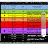
The wind gust and just.50 -.75 easily put Triad in cat 4, into cat 5 turf on that chart.
Jessy89
Member
This is gonna be nothing but cold rain in upstate sc (except maybe extreme northern) accept it and enjoy.
It will depend on where you are at in the upstate. I could see north eastern upstate from Spartanburg to rock Hill seeing a decent little event. While I don’t expect no more then maybe 0.05-0.10 in my part of Pickens county
Sent from my iPhone using Tapatalk
Stephenb888
Member
Maybe you will get some in Spartanburg. Even that’s pushing it.
iGRXY
Member
One thing I’m noticing is even the short range models are whiffing on just how dry the airmass coming over the mountains is. My DP is already 19 and almost all the short range guidance has me in the mid 20’s right now. Those small tweaks are what can knock off an additional couple of degrees at go time
Stormlover
Member
Read it again, I said a few hours or more. Regardless of if it changes to rain eventually.Will it not change over to rain later that night?
L
Logan Is An Idiot 02
Guest
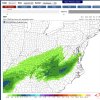
03z RAP. I think this is pretty realistic
iGRXY
Member
Listen, I get it. You haven’t had any wintry weather all season. That holds no weight in this event. Your area may not get anything but plenty of people in Greenville, Spartanburg, and Cherokee counties at a minimum are in the crosshairs for a serious ice potential. Don’t make a blanket statement like that when there’s nothing on your side both model guidance wise or even real time things like colder than forecasted temps, DPs, increased snow pack to support the statement strictly based on the fact that your neck of the woods hasn’t seen any winter weather or isn’t going to out of this.Maybe you will get some in Spartanburg. Even that’s pushing it.
Stephenb888
Member
Yep this is it. Much more realistic than what some are thinking.?
03z RAP. I think this is pretty realisticView attachment 75750
NBAcentel
Member
My update 2nd call, will update as needed, this one is looking bad ?? it would be so nice if I was dropping things south and upticking things for snow, but it’s ice unfortunately 
L
Logan Is An Idiot 02
Guest
Imo yes. This is how every ice event has been this year. Pretty much the same areas. I40 northYep this is it. Much more realistic than what some are thinking.?
NBAcentel
Member
Oh that’s nice to see a warmer solution, something to watch03z RAP. I think this is pretty realisticView attachment 75750
Jessy89
Member
My update 2nd call, will update as needed, this one is looking badit would be so nice if I was dropping things south and upticking things for snow, but it’s ice unfortunately View attachment 75749

That map looks pretty spot on to what is realistic to me. Including the upstate
Sent from my iPhone using Tapatalk
L
Logan Is An Idiot 02
Guest
I just think it makes the most sense climo wise. We shall see if other models trend like thatOh that’s nice to see a warmer solution, something to watch
Stephenb888
Member
Well I did say extreme northern upstate which probably includes you so idk what else to say.
Listen, I get it. You haven’t had any wintry weather all season. That holds no weight in this event. Your area may not get anything but plenty of people in Greenville, Spartanburg, and Cherokee counties at a minimum are in the crosshairs for a serious ice potential. Don’t make a blanket statement like that when there’s nothing on your side both model guidance wise or even real time things like colder than forecasted temps, DPs, increased snow pack to support the statement strictly based on the fact that your neck of the woods hasn’t seen any winter weather or isn’t going to out of this.