• Hello, please take a minute to check out our awesome content, contributed by the wonderful members of our community. We hope you'll add your own thoughts and opinions by making a free account!

Wintry Jan 30-Feb 2 2021 ❄️ Potential

The CAMS are what I feared in terms of models not picking up just how dry and cold the surface really is with the DPs being spit out. Just seemed like the temps were not corresponding and falling even with those low DPs like they should on these model runs. Even the NAM and RGEM look like they're not falling enough with the wet bulb. Do I think it will be as south as the CAMS are showing? No but areas along and north of 85 definitely should keep a close eye.
There’s often-almost always some modest dew point depressions in CAD, unless the precip is heavy. A continuous feed of cool dry air from the NE helps keep the dews slightly lower than actual temps even as sfc temps fall towards it. It’s hard for the temps to actually fall exactly to the wet bulb for this reason
 
This is why the cmc may not be very accurate. Lows tomorrow morning. I do not think it will be this cold.Screenshot_20210129-111329.png
 
Well for example, with that system in December. It was spitting out huge ice totals like it is right now. And most areas just got a cold rain.

Because those freezing rain maps are about as bad as COD GEFS snow maps. They see 1.25" of rain fell in 31 or 32 degree temps, and it's going to spit out Freezing Rain accruals of 1.25". Thats not how ZR works. We know water doesn't freeze instantly at 31 degrees so a lot runs off like a normal rain.

Use Fram.
 
I’ve seen it time and time again .. this CAD seems noticeably colder than the past “ice events” we’ve had as of recent which really just give the triad a wet .1-.25 of ice ??‍♂️ 
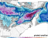
This one has cold temps on top of dry air ... even the stale events over preform ITS HARD TO move that cold air out ... models always preform poorly ... especially globals
 
Looks like the Canadian is coming in a little colder. Looks similar to the short range version RDPS.
 
This is why the cmc may not be very accurate. Lows tomorrow morning. I do not think it will be this cold.View attachment 69036
Are you basing this on a guess or do you have something to back it up. Same goes with "this model has a warm bias, or this model has a cold bias." Please show me where you find that info, I'm curious.
Now, I don't believe it will get that cold tomorrow morning, either, based on the fact the other models don't agree on lows quite that cold.
I said that because this model had me getting down to 15 this morning. I got down to 22. It's an extremely cold biased model.
 
Lets hope the RDPS does not win this model war. It has me at 1.25" of freezing rain; but that's not the worse location. Looks like northern Orange / southern Person counties would "jack pot" (in a bad way) at ~2.25". Terrible outcome for something like that...
Believe me, it won't. Terrible cold bias, and high QPF bias when it comes to sleet and ZR.
 
I said that because this model had me getting down to 15 this morning. I got down to 22. It's an extremely cold biased model.
Last night was clear with decreasing winds making way for ideal radiational cooling which the CMC struggles with being too cold. With CAD its cold bias is not near as bad.
 
Weak precip seems to be a thing with the NAMs even at this range. Soundings look ok on the 3K until noonish here but if the NAM does not trend a little colder, I would bet on mixing earlier than that. And yes, trust the warm nose on the NAM. View attachment 69024
The thing that is good about this is almost all of the models are guaranteeing 4+ inches. The question is how much longer does it snow after those 4 inches that could sneak us into the 6-8 range??
 
Looks like Ukie might have been a smidge colder... I don't have precip maps but looking at the snow map (which I know isn't all snow) it sagged south just a hair.
 
FRAM’d... Lol. More realistic outcome IMO. And I do expect this will start to go up if the models continue to trend colder as we get into Saturday afternoon.

81ee80fa0c9998cc5a6b644ab8cb34c6.jpg


Sent from my iPhone using Tapatalk
 
FRAM’d... Lol. More realistic outcome IMO. And I do expect this will start to go up if the models continue to trend colder as we get into Saturday afternoon.

81ee80fa0c9998cc5a6b644ab8cb34c6.jpg


Sent from my iPhone using Tapatalk
I see lesser totals west in the strongest Cad regions. Are they more IP than Zr in the west?
 
12z OP Canadian: The Grey Shade eastern 1/2 NC is from wrap around
1611941535475.png
12 canadian OP Frzng Rn
1611941571653.png
12z RDPS frzng RN
1611941610777.png
12z RDPS Clown
1611941635038.png

12z UKIE Clown
1611941710192.png

12z GFSFV (sonn to be old gfs is about the same: The eastern 1/2 nc shade is wrap around like Canadian wrap around
1611941817454.png
Both GFS confine Frzng rn up in VA are very minimal along escarpment
1611941896281.png

Then heres the 12 Nam
1611941946431.png
ONLY OUT TO HR 60 on 3k:

1611941990445.png
 

Attachments

  • 1611941513479.png
    1611941513479.png
    351.1 KB · Views: 13
1611942589535.png
1611942633635.png
This is my early thoughts right now. Think the escarpment and NW piedmont are likely to receive quite a bit of ICE in this setup. It will likely be a sharp cutoff the further east you go and closer to I77. Places like Hendersonville, Boone, southeastern Buncombe county, Morganton always do really well when it comes to CAD and ice setups where the cold air gets trapped next to the eastern slopes of the mountains and cold see quite a bit of ICE. along and just north of I40 and along I26 could see around 0.1" of ICE with higher totals the further west you go towards the mountains. NE Georgia to GSP to CLT and Raleigh could see a trace of ICE with higher totals north of those areas. TR, Landrum, Inman, and the Triad could definitely get in on more ICE. Totals could go up or down (leaning towards up witht he cold DPs around) the closer we get to the event.
 
Winter Storm Watch
URGENT - WINTER WEATHER MESSAGE
National Weather Service Greenville-Spartanburg SC
257 PM EST Fri Jan 29 2021

...WINTER STORM POSSIBLE ACROSS WESTERN NORTH CAROLINA SATURDAY
NIGHT INTO SUNDAY...

.A strong storm system will push into the Appalachians Saturday
night into Sunday. This combined with cold temperatures will
bring the possibility of a wintry mix of accumulating snow,
sleet, and freezing rain to western North Carolina.

NCZ033-035-036-049-050-053-056-064-065-501>510-300400-
/O.NEW.KGSP.WS.A.0003.210131T0300Z-210131T1800Z/
Avery-Alexander-Iredell-Yancey-Mitchell-Buncombe-Catawba-
Transylvania-Henderson-Caldwell Mountains-Greater Caldwell-
Burke Mountains-Greater Burke-McDowell Mountains-Eastern McDowell-
Rutherford Mountains-Greater Rutherford-Polk Mountains-
Eastern Polk-
Including the cities of Ingalls, Banner Elk, Newland, Bethlehem,
Ellendale, Millersville, Taylorsville, Hiddenite, Stony Point,
Statesville, Mooresville, Swiss, Burnsville, Celo, Micaville,
Ramseytown, Busick, Spruce Pine, Poplar, Asheville, Hickory,
Newton, St. Stephens, Brevard, Cedar Mountain, Little River,
Hendersonville, Fletcher, Dana, East Flat Rock, Tuxedo, Etowah,
Patterson, Kings Creek, Lenoir, Sawmills, Granite Falls,
Jonas Ridge, Morganton, Pleasant Grove, Valdese, Ashford,
Sugar Hill, Woodlawn, Old Fort, Marion, Nebo, Dysartsville, Fero,
Glenwood, Chimney Rock State Park, Forest City, Rutherfordton,
Spindale, Saluda, Tryon, Columbus, and Mill Spring
257 PM EST Fri Jan 29 2021

...WINTER STORM WATCH IN EFFECT FROM SATURDAY EVENING THROUGH
SUNDAY AFTERNOON...

* WHAT...Heavy mixed precipitation possible. Total snow and sleet
accumulations of up to 3 inches and ice accumulations of around
one tenth of an inch possible.

* WHERE...Portions of western North Carolina, including the
northern mountains, Blue Ridge, foothills and northwest
Piedmont.

* WHEN...From Saturday evening through Sunday afternoon.

* IMPACTS...Plan on slippery road conditions.

* ADDITIONAL DETAILS...Windy conditions will be possible across
the higher elevations of the Tennessee border counties Sunday
morning.

PRECAUTIONARY/PREPAREDNESS ACTIONS...

A Winter Storm Watch means there is a potential for significant
snow, sleet, or ice accumulations that may impact travel.
Continue to monitor the latest forecasts.
 
Back
Top