Clem282340
Member
Are the temps and dew points colder this run
Are the temps and dew points colder this run
That little middle finger of mix going into Roa is right over my house. bet it will be right and earlier. I mix earlier than anyone else I know around here.


Nope sat night it will look like a frozen movie Sun morning. U shud be good on driving though.Not trying to make an imby post but I will be in Hendersonville fri and Saturday. Leave Sunday morning. Please tell me this ice storm comes Sunday after I leave?

How did the 6z euro suite trend? The midatdlantic crew was not happy with it. Looks like they are losing the capture and the big totals for the second part of the storm. Wasn’t sure if the suppression they were talking about helped us any with temps and further south with the world yet weather.
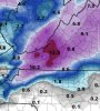
We haven't had a good one in years. Definitely not buying those amounts of 1.41 of ice. Be nice to have snow then a coating of ice on topI'll be test firing the generator if this is showing up tommorow morning
View attachment 69010
View attachment 69011
How did the 6z euro suite trend? The midatdlantic crew was not happy with it. Looks like they are losing the capture and the big totals for the second part of the storm. Wasn’t sure if the suppression they were talking about helped us any with temps and further south with the world yet weather.


My friend in Southern Delaware will be very happy with this mapThey still look great for a 6-8" event...but you can see it's heavier in central VA now.
View attachment 69017View attachment 69016
Even if that happened verbatim, 1.41” of QPF wouldn’t translate to anywhere close to 1.41” of freezing rain. Maybe 0.5-0.75”, tops (which is still bad, obviously).We haven't had a good one in years. Definitely not buying those amounts of 1.41 of ice. Be nice to have snow then a coating of ice on top
I'm rooting for it to shift north so that DC is on the cold rain line personally. Wilmington will be in the 60s during this event, I want some of that, please. Much better than a bitter 36-degree rain.I’m going to be kind of angry if Ji gets 18-24”. That’ll just make this winter suck even more.
Gotta get a snowpack to the north to help bring down cold to NC !I’m going to be kind of angry if Ji gets 18-24”. That’ll just make this winter suck even more.
What are the dew points looking like3K NAM much colder and holds temps around 33-34 in the upstate which is a step towards a big issue.
? It looks warmer to me3K NAM much colder and holds temps around 33-34 in the upstate which is a step towards a big issue.
Looks better around our neck of the woods.? It looks warmer to me
Its coming in warmer lol, as someone mentioned things shifted NWHow is the Nam coming in much colder and warmer?
I know I'm not in NC but the temp on the name has been ticking down degree by degree here. 35 this run vs 37 last night. A couple degrees colder and we could have ice. And it holds the entire event to at that temp.How is the Nam coming in much colder and warmer?
Guess it depends where you areIts coming in warmer lol, as someone mentioned things shifted NW