Webberweather53
Meteorologist
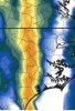
NAM isn’t alone View attachment 59275
Lol uh oh. Welp, here comes an outbreak
NAM isn’t alone View attachment 59275
I’m wondering how far west we can get this atp, more we slow that trough down and allow it to tilt much more favorably, the further west and further more the parameters will be enhanced (doesn’t that remind you of a setup) yay, seems like we can trend towards more severe only nowadays and not snowLol uh oh. Welp, here comes an outbreak
Easter Sunday was the first and lastThe Storm Relative Helicity is freaking off the charts Thursday evening. I don’t know if I’ve ever seen numbers this high just ahead of the squall line.


Sent from my iPhone using Tapatalk


Wait what even happened on Easter? Can someone post the storm reports?Easter Sunday was the first and last
this time isn’t much of the SE, but for areas further East is where the highest threat is this timeWait what even happened on Easter? Can someone post the storm reports?


.png")

.png")

Welp at least we’re getting some sort of ice on Christmas ?12km NAM is showing potential for elevated supercells in central NC & eastern SC as early as Xmas Eve morning, primary threat of hail
Not a fan of these storms that get going on their own ahead of everything. Some decent UH streaks associated with theseView attachment 59367


The kind of parameters the NAM is currently spitting out remind me a little of the Easter Outbreak we had earlier this year


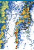
Hrrr is basically a QLCS with embedded rotation with storms out ahead, a QLCS like that would drag plenty of wind down, hrrr also has some super-cellular looking stuff east View attachment 59524View attachment 59525View attachment 59526View attachment 59527
Yeah I’m honestly thinking between 77-95 there’s more of a wind/isolated tor threat while areas East of 95 have a more higher tor threat, I imagine they’ll expand the slight west and perhaps introduce our first enhanced in a whileSort of concerns me that line fractures as it heads into some of the better cape and dynamics over towards ENC/ESC. Those semi-discrete cells spell trouble potentially.
Here’s what I’m thinking, areas in the first circle have a isolated tornado threat, but a much bigger chance of damaging winds, it doesn’t take much to drag down those strong winds aloft with this sort of setup, LLJ is around 70-80kts which is insane
Areas around 77/East have a better shot at isolated tornadoes/Convective damaging winds gusts
2nd circle is where there’s a higher tornado threat, as some isolated supercells May form around this area, and is also where the best instability will be, the squall line should have better access to cape in ENC/ESC
View attachment 59505
That's getting awfully close to me with that line. If that 19z map verifies, there will be very widespread wind damage over much of central NC and SC. Then maybe a big hail and tornado threat from Florence and Raleigh east when the line breaks up if the next map works out.Hrrr is basically a QLCS with embedded rotation with storms out ahead, a QLCS like that would drag plenty of wind down, hrrr also has some super-cellular looking stuff east View attachment 59524View attachment 59525View attachment 59526View attachment 59527
I mentioned this a few weeks ago that the last Enhanced risk anywhere was on September 5th. Pretty unusual to go 3 and a half months without one.Yeah I’m honestly thinking between 77-95 there’s more of a wind/isolated tor threat while areas East of 95 have a more higher tor threat, I imagine they’ll expand the slight west and perhaps introduce our first enhanced in a while
Very, even tho winter weather is possible with blocking, I wouldn’t sleep on severe eitherI mentioned this a few weeks ago that the last Enhanced risk anywhere was on September 5th. Pretty unusual to go 3 and a half months without one.
Very, even tho winter weather is possible with blocking, I wouldn’t sleep on severe either
Yep it sure is. About 2-4 hours slower putting me in the game now. Shows a solid line coming through here around 4 now with dewpoints touching 60. Higher than that from I-77 east. 850 winds right at 70 knots over me too as that line moves through.NAM is even further west.....


Nasty looking wind event from Raleigh and east in NC. Looks like it stays a solid line on this run.


peep the EML View attachment 59536
Exactly what am I looking at here