BufordWX
Member
WTH... Tornado Warning north of Jackson, Mississippi. I think there is barely any instability here. lol 
Well I've gone and done it. In order for my son to see his xmas gift on xmas mornin and in light of our impending outbreak I put his gift together today. It's a 14ft trampoline which means it sure 100% bound to be destroyed by storms tomorrow. We have so far kept him from seeing.
I've got 4 bags of sand 25lb each on four of the bases and its tied off to the palm tree as an extra.
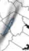
Looks like we had/have a tornado on the ground with this one.WTH... Tornado Warning north of Jackson, Mississippi. I think there is barely any instability here. lol View attachment 59822

WTH... Tornado Warning north of Jackson, Mississippi. I think there is barely any instability here. lol View attachment 59822

Good luck keeping him from seeing it.. let me know how that goesWell I've gone and done it. In order for my son to see his xmas gift on xmas mornin and in light of our impending outbreak I put his gift together today. It's a 14ft trampoline which means it sure 100% bound to be destroyed by storms tomorrow. We have so far kept him from seeing.
I've got 4 bags of sand 25lb each on four of the bases and its tied off to the palm tree as an extra.
Yep with these dynamics it will not take much. Eastern NC looks to be in for a rough time. A lesser threat back to the west from around highway 321 and east from there. 1 or 2 hours later on timing could put me in play too, but I don't think it'll happen. That line is halfway across GA already.Rah NWS less impressed stating lack of instability and uncertaint how far west the warm sector can penetrate. Well I just got more concerned, temp up 16° since 6:30 am
Rah NWS less impressed stating lack of instability and uncertaint how far west the warm sector can penetrate. Well I just got more concerned, temp up 16° since 6:30 am
Good luck keeping him from seeing it.. let me know how that goes
60/59 at the house.Wind advisory issued now, sun was trying to beak through but solid deck of clouds has moved back in.... probably most unstable and best chance of severe will be east of 95 but a brisk warm Christmas Eve none the less.
63/60 here, we're on that border.... which could be problematic later. Will be watching to see how it progresses throughout the day that's for sure60/59 at the house.