NoSnowATL
Member
looks like a map I’d see with a summertime central US death ridge setup that shuts off spring severe
Nope, just shuts off Winter Snow.
Sent from my iPhone using Tapatalk
looks like a map I’d see with a summertime central US death ridge setup that shuts off spring severe
South-based -NAO?
Ho Ho Ho
Sent from my iPhone using Tapatalk
South-based -NAO?
Well considering that storm happened almost at the beginning of March when our climatology is several degrees warmer than it is in late December, this point is pretty mute.
Should translate to lower heights over French GuianaSouth-based -NAO?
Looks that way. Except the NE.So are you saying we're finally going to get a -NAO, and still torch? &^#$


Told ya!
Sent from my iPhone using Tapatalk
Never heard of such name before.
Sent from my iPhone using Tapatalk
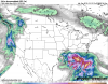
Wow just got a chance to see the 12z euro. What a track. That would be a super awesome snowstorm around many parts of the SE.... if it was cold enough. ?
Told ya!
Sent from my iPhone using Tapatalk


Phase 7 looks better to me if it happened imo.
This is just beyond depressing. In fact that will be solidly top five on the winter fail scale if it verified.
Yes it would. How bad was 2m?This is just beyond depressing. In fact that will be solidly top five on the winter fail scale if it verified.
Told ya!
Sent from my iPhone using Tapatalk
I believe phase 7 is classic for winter storms.
Sent from my iPhone using Tapatalk
Yes it would. How bad was 2m?
@Webberweather53 ,what would a convectively coupled Kelvin wave do for sensible weather if it happens? I mean in general with mjo and other things. Thanks in advance.Phase 7 in January loves to produce winter storms in the Carolinas.
EwwwLooks like mid 40s to lower 50s.
Ewww
@Webberweather53 ,what would a convectively coupled Kelvin wave do for sensible weather if it happens? Thanks in advance.
I gotcha. Thanks. You seemed intrigued when you noticed that on the eps chart.A convectively coupled kelvin wave is effectively a faster moving MJO pulse operating on timescales of a few weeks or so, thus said wave would probably yield us a pattern that somewhat resembles "x" phases of the MJO although this is not always necessarily true because CCKWs may not be as tightly coupled to the extratropical circulation as an MJO event.
Bad enough with no cold air but now no storm
Yeah your right about that, I dont buy this run with no low in the gulf. Icon looked better.Believe it or not, this run was still very close to snow in NC with 850s barely above freezing and sfc temps in the 30s
You promise?Guys we gonna have to wait till January. We get a storm just gonna take till January.
Sent from my iPhone using Tapatalk
You promise?
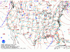
The Canadian has a cold bias so take a few degrees off and you have the GFS.the Canadian can kick rocks, but here it is anywayView attachment 28214