Fountainguy97
Member
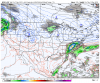
pretty obvious trend on the gfs.
Let’s see what 12z has for us.
NAM 12z also supports the SW holding together longer over Texas

Let’s see what 12z has for us.
NAM 12z also supports the SW holding together longer over Texas