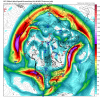
Interesting trend on this GFS run, the high in MN, is 1038, as it moves into WI, it’s a 1041, little trends, but interesting!
-
Hello, please take a minute to check out our awesome content, contributed by the wonderful members of our community. We hope you'll add your own thoughts and opinions by making a free account!
You are using an out of date browser. It may not display this or other websites correctly.
You should upgrade or use an alternative browser.
You should upgrade or use an alternative browser.
Pattern The Great December Dump
- Thread starter Rain Cold
- Start date
Fire it up, Huntsville!
Some kind of phase about to pop off!


accu35
Member
Second storm oh goodness
Where’s the moisture!???
This run looks better we were able to keep the high around a little longer might be in for an interesting run....

But after this the high moves out and the low moves immediately NNE through central GA, SC, and NC?
But after this the high moves out and the low moves immediately NNE through central GA, SC, and NC?
Last edited:
We toss! There’s basically a hurricane over Augusta! 
accu35
Member
Let's bring this baby home

Room for improvement? NextWe toss! There’s basically a hurricane over Augusta! View attachment 27313

accu35
Member
A few more degrees difference and timing little better than that second storm will be a dream come true for us weenies
BufordWX
Member
Here are the ice accumulations from the gfs. Some sizable amounts over North Georgia 
Fwiw the CMC is more separated

dew points are solid enough to get the job done prior, but low track is atrocious. That unfavoranle
ridging isn’t going anywhere. DP’s go up in flames. It’s not as close as precip maps make it out to be. We might have a chance or two in February. I wouldn’t completely give up hope yet
ridging isn’t going anywhere. DP’s go up in flames. It’s not as close as precip maps make it out to be. We might have a chance or two in February. I wouldn’t completely give up hope yet
BufordWX
Member
Canadian looking interesting for storm #1.

accu35
Member
Cmc looks better with first system
NBAcentel
Member
Starting to look like overrunning with snow is gonna be legit over Tennessee
ATLwxfan
Member
Let's bring this baby home
Hard pass on an ice storm.
Sent from my iPhone using Tapatalk
accu35
Member

GeorgiaGirl
Member
That second piece of energy starts to phase later, and that's actually why it starts tracking up. But I'm looking at the 500 mb maps, and although I'm tired, it doesn't look like there's many ways for it to stay shoved down in the gulf and track west to east, IMO. The northern pieces of energy would need to get in front without interacting to keep it down.
There might be an icing problem anyway to start out though. Doesn't take a lot for problems.
There might be an icing problem anyway to start out though. Doesn't take a lot for problems.
The apps rubber and cutters are lined up one after another on this run! Not a good pattern on GFS. Yes, we are not 20 degrees above normal, but watching cutters and runners for a week or two, will get old
ATLwxfan
Member
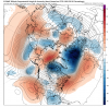
The apps rubber and cutters are lined up one after another on this run! Not a good pattern on GFS. Yes, we are not 20 degrees above normal, but watching cutters and runners for a week or two, will get oldView attachment 27321
But frankly climatologically expected. January and February may be better.
Sent from my iPhone using Tapatalk
Clay
Member
Lol, this map is more Nashville than hot chicken and bachelorettes.Let's bring this baby home
Boom....
accu35
Member
Am I missing something? Lol
Ilovesnow28
Member
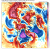
@WxWatch due you think areas further south lets say I-20 south have a chance to see something if this storm verifysI'm liking what I'm seeing on tonight's 0z GFS and CMC. The timing is still off with the 2nd S/W (imo.) But the the timing with things are slowly getting there. I still think that 2nd S/W will start moving quicker, catching up to the tail end of the first wave. I'm not agreeing that the high sliding out first, and then the low pressure comes about. Soon as the strong high pressure slides southeast from Canada, I have confidence that a low pressure will develop on the tail end of the first (overrunning wave) underneath the strong high. I have calculated that arctic high will have an air pressure mean value of 1040mb as soon it drops down out of Canada. I have chosen the 0z CMC 500mb(vort) verses the 0z GFS for the 2nd S/W because it has the wave in the ideal location. That S/W that I circled in black would be the major winter storm according to my predictions. I'm still going with my original prediction, we would start seeing the beginnings of the low development early as Wednesday down in the Gulf of Mexico. View attachment 27326
Ilovesnow28
Member
Hey @Arcc can you explain what that means for us deep south folksOh wow. Triple phaser incoming....
I'm getting chills...
Hey @Arcc can you explain what that means for us deep south folks
Probably about the most miserable model run in history unless more cold air gets involved.
Phased too late. Not that it matters anywho.
Incoming..
Keep in mind this was IP/ZR..jeebus
Strong coastal just inland gulf (Florida) convection maybe it will help rob most of the moisture.
That’s one way to get it done. Timing was impeccable on the 06z.. I would be shocked it matches reality 
Keep in mind this was IP/ZR..jeebusView attachment 27330
You could see the GFS has been trending towards that. It’s close to what the Euro had a few days ago with the timing. JMA is showing this but UK and latest Euro runs are not close to to this.


Cad Wedge NC
Member
That's one heck of a wedge.... temps here in the low 20's with a pronounced sleet sounding during most of the event. Starts as a little snow and ends as some freezing rain. Temps never get up to freezing. Wow... Let's see what the king has to say in a little bit.That’s one way to get it done. Timing was impeccable on the 06z.. I would be shocked it matches reality View attachment 27331
Webberweather53
Meteorologist
These changes are within the realm of error at this stage but goes to show the importance of stream separation when you realize the end result. 0z EPS is still trending the other way however

Fwiw GEFS mean is much more than the 0z was. Beware this changes other frozen p-types to snow
