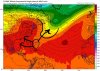
1. The SSTs didn't cool much off the SE coast and they're already warming back up thanks largely to a very hot SE. For example, KSAV just had the 3rd 97 in a row.
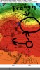
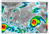
2. I'm actually more concerned about a storm going into the Gulf. IF the next storm tracks through the western Caribbean and Gulf, it would be going through water that hasn't been tapped in quite awhile and there also have been no sig cold fronts to cool the waters thus leaving it very hot. The SSTs are boiling...I mean nearly 1 C warmer than they were just before Michael came through in some areas! Most of the open Gulf and W Caribbean is ~86-87 range with some open areas even close to 88! Just before Michael, it was at or near record warm for early Oct., but even that was more like 84-6. Also to compare, the warmest open ocean SSTs in Dorian's path were near 86-7 (Bahamas). That's quite concerning, especially if it is not crawling slowly enough to lead to weakening due to its own wake.
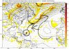
Unless that wave now north of the Greater Antilles were to develop much and cool the Gulf some, the Gulf will likely still be about this hot if the far E Atlantic entity were to track this way as I don't see any sig cold fronts during the next 14+ days with well above normal temps continuing.