LovingGulfLows
Member
- Joined
- Jan 5, 2017
- Messages
- 1,499
- Reaction score
- 4,100
RGEM has me getting 2 hours of snow...I'll take it lol. It's trending better for GA.


I can’t unsee the gfs
Sent from my iPhone using Tapatalk
So much for not watching the models for the rest of the day.
So much for not watching the models for the rest of the day.

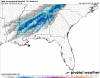
Euro/GFS VS NAM/RGEM. Under 24 hours

NWS said it would be 10:1 ratios
Euro/GFS VS NAM/RGEM. Under 24 hours
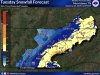
So has the JAX officeLooks like BMX expanded the winter storm warning southward.
Will, you mean JAN. JAX is Jacksonville, FL.So has the JAX office
Sent from my SM-G950U using Tapatalk

Yet the NWS says the opposite, that the models are underestimating it. Throw out the Crankyguys stuff ;-)Crankywxguy on twitter said this thing is gonna be severely moisture starved and will undercut expectations.
Crankywxguy on twitter said this thing is gonna be severely moisture starved and will undercut expectations.
Crankywxguy on twitter said this thing is gonna be severely moisture starved and will undercut expectations.


not the normal "cold chasing moisture" setup..as most of the precip is behind the front to begin with.My experience in these situations (and being burned many years ago when first following weather models) is as follows.
1. The cold air is usually slower to arrive than modeled.
2. The back edge dries up quickly as earnest CAA kicks in.
3. Many times these “cold chasing moisture” scenarios end up with flurries at best on the backside.
4. The 3km NAM and RGEM blended is the best way to go in the short range.
Having said that I sure hope this event turns out differently but trusting the globals over high res models this close usually isn’t a good idea. Good luck everyone, I hope you get a nice snow!


not the normal "cold chasing moisture" setup..as most of the precip is behind the front to begin with.
I just said it's not the normal setup. Usually most moisture is ahead of the front and it's truly trying to catch up before it's gone. In this case most will end up behind the front and it's only a matter of the changeover...not with flurries, but the most moisture being snow. We don't get winter storm warnings for true cold chasing moisture events...there is some back building of moisture behind the front..that's why some areas may get hit hard in Alabama, while up in Tennessee, not much at all. True cold chasing moisture events do better farther north.It’s definitely a cold chasing moisture setup. Temperatures through the entire column have to cool enough before snow can fall and is the reason the RGEM and 3km NAM are very light with snow and show mostly rain before a brief ending as snow. Global models struggle to pick these things up. Trust me, I learned the hard way many years ago when I first started following the weather closely and watching models.
I just said it's not the normal setup. Usually most moisture is ahead of the front and it's truly trying to catch up before it's gone. In this case most will end up behind the front and it's only a matter of the changeover...not with flurries, but the most moisture being snow. We don't get winter storm warnings for true cold chasing moisture events...there is some back building of moisture behind the front..that's why some ares may get hit hard in Alabama, while up in Tennessee, not much at all.