URGENT - WINTER WEATHER MESSAGE
National Weather Service Peachtree City GA
236 PM EST Sun Jan 27 2019
GAZ001>009-011>016-019>023-030>034-041>045-052>055-280345-
/O.NEW.KFFC.WS.A.0001.190129T0900Z-190130T0300Z/
Dade-Walker-Catoosa-Whitfield-Murray-Fannin-Gilmer-Union-Towns-
Chattooga-Gordon-Pickens-Dawson-Lumpkin-White-Floyd-Bartow-
Cherokee-Forsyth-Hall-Polk-Paulding-Cobb-North Fulton-Gwinnett-
Haralson-Carroll-Douglas-South Fulton-DeKalb-Heard-Coweta-Fayette-
Clayton-
Including the cities of Calhoun, Dahlonega, Cleveland, Rome,
Cartersville, Gainesville, Marietta, Atlanta, Lawrenceville,
Carrollton, Douglasville, East Point, Decatur, Newnan,
and Peachtree City
236 PM EST Sun Jan 27 2019
...WINTER STORM WATCH IN EFFECT FROM LATE MONDAY NIGHT THROUGH
TUESDAY EVENING...
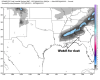
* WHAT...Snow possible. Total snow accumulations of up to 2
inches, with locally higher amounts possible in the higher
terrain of northern Georgia.
* WHERE...Mainly along and north of a line from Franklin to
Jonesboro to Gainesville.
* WHEN...From late Monday night through Tuesday evening.
* ADDITIONAL DETAILS...Travel could be very difficult. The
hazardous conditions could impact the morning or evening
commute.
PRECAUTIONARY/PREPAREDNESS ACTIONS...
A Winter Storm Watch means there is potential for significant
snow, sleet or ice accumulations that may impact travel. Continue
to monitor the latest forecasts.
&&
$$