NCCWOP9077
Member
Looks like roughly 12/20 members have measurable snow in central NC, will certainly watch as models converge on a solution in the coming days. Sometimes arctic fronts produce east of the mountains, sometimes they don't.
Looks like roughly 12/20 members have measurable snow in central NC, will certainly watch as models converge on a solution in the coming days. Sometimes arctic fronts produce east of the mountains, sometimes they don't.
I don't think so. An inch on top of ice is perfect. I would be happy.I think people’s expectations are too high . One maybe two inches is far more realistic at this point . As has been mentioned already these things tend to dry up the closer we get

I think people’s expectations are too high . One maybe two inches is far more realistic at this point . As has been mentioned already these things tend to dry up the closer we get
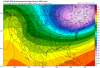
FV3 Kuchera map:
View attachment 12966
That will also suffice.
Holy cow12z Euro: much more snow AL+ 1/29!

DANG!!!
12z Euro: much more snow AL+ 1/29!


I can’t see what’s going on with my crappy maps but it looks like a 1010 Lp entering Baja?Just looking at the GFS, FV3 and Euro, I have a hunch there probably be something around the 31st.
Wow!! Big increase on cold plus moisture


I can’t see what’s going on with my crappy maps but it looks like a 1010 Lp entering Baja?
Excellent trend for Jackson MS. I think I will go up there next Monday evening
Is there a chance this shows up in the coming days on the models? I know it has been hinting at it on and off but has disappeared today.Timing of the front + blocking of low-level cold air by the Appalachian mountains is what hurts the snow/sleet totals in the Carolinas, need to see a weak wave form along the front and throw more moisture back into the cold air to get something more substantial.
Timing of the front during the middle of the day + blocking of low-level cold air by the Appalachian mountains is what hurts the snow/sleet totals in the Carolinas, need to see a weak wave form along the front and throw more moisture back into the cold air to get something more substantial. North-central Mississippi, Alabama, Georgia, & Tennessee plus the mountains of NC are obviously favored in a setup like this.
Is there a chance this shows up in the coming days on the models? I know it has been hinting at it on and off but has disappeared today.
Why did the weather channel just take the snow out of my area in north Alabama?
Why did the weather channel just take the snow out of my area in north Alabama?