BHS1975
Member
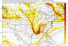
SE trend baby
Sent from my iPhone using Tapatalk

If the FV3 shows a storm 14 days out, you book itWould be a nice hit for many. Just wish it was within 240 hours. View attachment 9107
The overall pattern looks favorable leading up to late December for a potential Sudden Stratospheric Warming Event in the form of a wave 1/displacement event with troughing dominating the Bering Strait & Eastern Siberia and a huge high over Scandinavia, both of which are projected onto the standing planetary wave pattern and will increase wave forcing onto the polar vortex, decelerating the polar night jet, and leading to considerable warming in the polar stratosphere.
The question becomes how significant is this warming, does it actually perturb the tropospheric vortex enough to give us a prolonged period of high-latitude blocking in January & even February, and how will tropical forcing (the MJO esp) evolve in tandem w/ this potential SSWE?
The answers to all these questions are still in the air atm, the MJO's amplitude may increase in a few weeks time though given the polar stratospheric warming that leads to acceleration of the Brewer-Dobson Circulation, ultimately affecting the shear & static stability of the tropical tropopause (in this case, cooling it and thus being more conducive to near-equatorial convection), and typically it takes a few weeks for the tropospheric vortex to significantly respond to a sudden stratospheric warming event like this unless the warming is initiated in the troposphere first, thus I wouldn't anticipate this to really have much of an effect on our pattern until early-mid January.
Until then, the tropospheric vortex will leave North America and migrate towards Siberia, temporarily exhausting the North American continent of cold air. However, as the vortex digs towards Siberia, it will induce downstream ridging in the NE Pacific and Alaska, (-EPO), which will then reload the continent with cold air and create a pattern we've come to all know & love the last several years in the southern US, giving us a favorable look for wintry weather in the southern US yet again as early as the last week of December, with the SSWE potentially influencing our chances in January & beyond perhaps.
What’s great about this particular map. I know it won’t really pan out this way. But it shows snow for Pickens and Oconee counties in sc. and gives everyone else rain. Usually what happens is Greenville Spartanburg Cherokee county’s sc see more snow then Pickens and Oconee counties
Sent from my iPhone using Tapatalk

I’m not sure what you mean “the tropospheric vortex will leave North America” What do you mean? What would cause that to happen? I don’t see nothing that would suggest that?
Sent from my iPhone using Tapatalk


Need that bad boy further southWould be a nice hit for many. Just wish it was within 240 hours. View attachment 9107
Merry Christmas from the FV-3. Has a similar look as the last storm.
View attachment 9104
With the pattern we got this winter an epic board wide storm is pretty much a guarantee.
Sent from my iPhone using Tapatalk
I was looking at the 23-30 time period last week and it still looks promising.
Omg, you made me bust laughing when I saw this.Everyone looks at that period . We all want the hallmark movie of snow falling Christmas morning opening gifts with our loving families . Problem is , normally it’s a brown ground and we are with family members we can’t stand
Sent from my iPhone using Tapatalk
Ongoing poleward heat flux over the coming two weeks will continue to disrupt the polar vortex, sending it towards Siberia.
Granted, this is the stratospheric PV, but it makes it easier to see what @Webberweather53 was referring to.
View attachment 9112


Snowfall map looks like an Apps rubber hybrid. So I’ll tossView attachment 9115
this falls on the 25th in N AL. Come to papa
Snowfall map looks like an Apps rubber hybrid. So I’ll toss
We no longer care about the Carolinas they’ve already cashed in . Is back to the west can do very well with an apps runner so.....
Let her run !!!
Sent from my iPhone using Tapatalk
We no longer care about the Carolinas they’ve already cashed in . Is back to the west can do very well with an apps runner so.....
Let her run !!!
Sent from my iPhone using Tapatalk
When you say entire Southeast you are not including Florida right?I saw absolutely nothing. We has not cashed in. Thankfully, for my area, its not always a bad thing for Dallas all the way over to here to get hit while having limited moisture further North.
I mentioned last night I was feeling something coming out of the gulf/phase.. well the FV3 from 06z kinda showed something that could be very special for the entire Southeast if timing could work out for Christmas Week.
When you say entire Southeast you are not including Florida right?
We no longer care about the Carolinas they’ve already cashed in . Is back to the west can do very well with an apps runner so.....
Let her run !!!
Sent from my iPhone using Tapatalk
Im kinda surprised the west coast of FL doesnt get more ocean effect snow. You would think those cold northerly winds coming off the Gulf would produce snow more often, kinda like how cold air moving over the Great Lakes produce Lake Effect Snow.Wouldn’t it be something to get snow into Florida
Sent from my iPhone using Tapatalk
Okay now, what’s that about the Carolinas? Lol need more in the upstate.
Sent from my iPhone using Tapatalk
Wouldn’t it be something to get snow into Florida
Sent from my iPhone using Tapatalk
Right! I admit, I'm jealous of the Carolinas getting that snow storm that dropped hefty snow amounts in some places. Some places got more than their average snowfall. It's TX to GA turn now!We no longer care about the Carolinas they’ve already cashed in . Is back to the west can do very well with an apps runner so.....
Let her run !!!
Sent from my iPhone using Tapatalk
I saw a video where one part of Florida got some graupel over the past week.Wouldn’t it be something to get snow into Florida
Sent from my iPhone using Tapatalk
")
