Cary_Snow95
Member

Yeah much closer in than 12z
Yep a big jog west. Is this the beginning of a correction back to what the euro and UK are showing? We’ll see.
Yeah much closer in than 12z
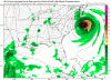
View attachment 6006 Flo looks bad
Not that bad. Let’s not get carried awayAbout as bad as South Carolina?
Looking back at it, the GFS and Euro are really similar with the stall and the location of the stall. The Euro makes landfall further west but stalls at the same latitude as the GFS. Seems like were getting agreement on a stall.
Agreed. A stall right after landfall or along the coast for 96 hours is disastrous to say the leastOne thing we can hope for is Florence slows down even more and allows the stall to happen sooner, away from the coastline.
Far more deaths and physical destruction are cased by flooding than wind ... though both absolutely suck ... and that's spoken with real life been there done that ...Flooding may end up being the biggest disaster with Florence

about the only, and only, thing good about that is there's a big place to run off in to; can you imagine 45" at the top of the Cape Fear? Jeeze, all of coastal NC would be under water and Wilmington would float away ...45 inches of rain near Hatteras and its not even done
1st damn likeable thing this storm looks to do ...And now the gfs is into NYC at day 10


This would permanently alter the OBX. Would be hard to come back from this. They already have new inlets and sounds forming on a relatively regular basis but this storm would create some of its ownLots of crazy totals
Sent from my SM-G955U using Tapatalk


I have a friend that I went to high school with and they just told me Jim Cantore is in Oak Island NC right now..
Yes. I know4-5 days before the storm hits?
That dude has a good gig.Yes. I know
No doubt!That dude has a good gig.
.png")