Brent
Member
Hwrf into the 920s pressure by day 4 and yeah that
Did I miss the 18z gefs? Any maps, trends or other analysis would be appreciated. I’m curious if the sw shift continued. Thanks!

New cone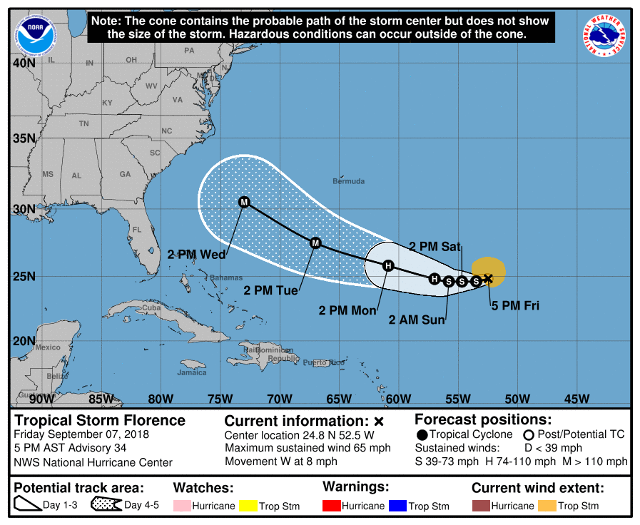
The HWRF is about a degree further west on the 18z but much stronger, showing Florence flirting w/ category 5 status in as little as 4 days.
View attachment 5937


.png")


Don't forget to mention the 225 mph winds at the 850 mb level either! Reminds me of what the HWRF spit out for Irma last year.Take it for what it's worth because it's the HWRF, but given Florence's history to even exceed MPI, small size, and environmental conditions it'll encounter over the SW Atlantic, can't rule out the HWRF being onto something here and/or discounting Florence becoming a category 5 hurricane sometime in the next 5-7 days.
View attachment 5939
View attachment 5938

 Could get wet too!
That could play a big role also on where it go. What do some of you guys think about this feature?18z GEFS interaction with ull in SE.
+1000 glad it’s looking like Ga is going to be on the safe side.... as of now.Prayers for those in the path of this potentially extremely dangerous situation.
Can't say a thing until the recon data gets into the models after tomorrow's flights. Still a chance anywhere from Jacksonville to OBX I would say+1000 glad it’s looking like Ga is going to be on the safe side.... as of now.

I’m gonna just drop my guess here: we get 5”+ of rain and 60mph gusts as it hits NFL or GA coast, and goes right over usLooking like Mack and I can watch this one safely from a distance (subject to change) I’ll take my 1.5” rainfall and call it a season. Wake me up when September ends
+1000 glad it’s looking like Ga is going to be on the safe side.... as of now.
 Jimmy H, look at Johnny C, true weather pimp! The outflow on Flo, looking good!
I see what you did there. The old “5 day out snowstorm. Buy the milk and bread” approach. I want no part of this. I’m calling for a hit Myrtle Beach or north. I just remember with Mathew things kept changing and changing and I thought I knew where it was going but never even had a clueI’m gonna just drop my guess here: we get 5”+ of rain and 60mph gusts as it hits NFL or GA coast, and goes right over us
JC is a beast of a meteorologist. He’s a likeable down to earth figure. He’s the reason I love tracking winter weather. Hard to beat that childhood excitement of turning on the 5 o’clock news and hearing John hype an incoming snowstorm. Good timesView attachment 5946 Jimmy H, look at Johnny C, true weather pimp! The outflow on Flo, looking good!
If that’s the case, this thing isn’t done going southLatest info is the winds are down to 60 mph and pressure is up to 999. Thought it was done weakening. This means trouble I bet.

If that’s the case, this thing isn’t done going south

Convection has really been blowing up over the past couple of hours with Florence. She looks a lot better now than she did 12 hrs. ago this morning. She may be prepping to blast off over the next 12+ hrs. You can even see lightning near some of the heaviest concentration of convection.


This would be a monster.View attachment 5943
Maybe I’ve never noticed it before but the enormous anticyclone models predict over Florence leading up to landfall is VERY concerning to me.
CMC
View attachment 5948
View attachment 5949
View attachment 5950

It may be laughable but with weather these days nothing suprises me sorryThe HWRF is laughable at best guys.. come on.
Not trying to be a debbie downer for the ones who want some low pressure monster floating around out there... but those pressures can't be taken seriously... ensemble members of various modeling have nothing of that low of pressure. In fact, few, if any, ensemble members of more reliable guidance even look like the GFS's pressure estimate.. which so far has been the lowest of the Global suites.
I was going to see this has already defied history if it even hits land with where Flo was at.It may be laughable but with weather these days nothing suprises me sorry
The HWRF is laughable at best guys.. come on.
Not trying to be a debbie downer for the ones who want some low pressure monster floating around out there... but those pressures can't be taken seriously... ensemble members of various modeling have nothing of that low of pressure. In fact, few, if any, ensemble members of more reliable guidance even look like the GFS's pressure estimate.. which so far has been the lowest of the Global suites.
IYou can see the shear has increased almost acting to help vent the storm from SW to NE creating the increased convection that’s to the NE of the center
Sent from my iPhone using Tapatalk
gotta get through that shear firstLatest discussion on the storm is not pretty. Cone is SW again and the forecast calls for major RI and 130 mph on day 4 and 5. My worry is the repeat in 130 mph may end up putting day 5 stronger in the end. The cone aims for NC/SC border now.
Latest discussion on the storm is not pretty. Cone is SW again and the forecast calls for major RI and 130 mph on day 4 and 5. My worry is the repeat in 130 mph may end up putting day 5 stronger in the end. The cone aims for NC/SC border now.
.png")
