-
Hello, please take a minute to check out our awesome content, contributed by the wonderful members of our community. We hope you'll add your own thoughts and opinions by making a free account!
You are using an out of date browser. It may not display this or other websites correctly.
You should upgrade or use an alternative browser.
You should upgrade or use an alternative browser.
Tropical Major Hurricane Florence
- Thread starter ForsythSnow
- Start date
Storm5
Member

Sent from my iPhone using Tapatalk
accu35
Member

ForsythSnow
Moderator
I think a spray bottle would be ineffective or even help the storm if we all sprayed it.we should all tell FLO
I swear on visible satellite , let looks like an eye is trying to reform! Even if not, it looks to be strengthening pretty quickly
Not sure if any one posted this from the UKMET 12z ens
Even further north UK ens mean at 80W due to far fewer FL hits
Mean at 80W
12Z 9/6 run: 29.5N
0Z 9/7 run 31.5N
12Z 9/7 run 34.5 N extrapolated
Last edited:
I swear on visible satellite , let looks like an eye is trying to reform! Even if not, it looks to be strengthening pretty quickly
Don't be fooled, the center is on the southern side of the convection.
ForsythSnow
Moderator
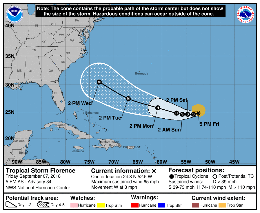
D 5 is the only part of the new cone that is further north of the previous cone, though it's not much. The NHC also expects another 36 hours of Florence being a TS before explosive RI.
NWMSGuy
Member
Does NOAA still use Storm Floaters for these systems? I didn't see any available for Florence in the link below:
http://www.ssd.noaa.gov/PS/TROP/floaters.html
http://www.ssd.noaa.gov/PS/TROP/floaters.html
NWMSGuy
Member
Cancel that. I see there is none available for GOES 16...Does NOAA still use Storm Floaters for these systems? I didn't see any available for Florence in the link below:
http://www.ssd.noaa.gov/PS/TROP/floaters.html
I had the same question the other day. Check out the satellite resources on Tropical Tidbits. You’ll get all the floaters you want.Cancel that. I see there is none available for GOES 16...
")
pcbjr
Member
Also our Wiki ...I had the same question the other day. Check out the satellite resources on Tropical Tidbits. You’ll get all the floaters you want.
Even further north UK ens mean at 80W due to far fewer FL hits
Mean at 80W
12Z 9/6 run: 29.5N
0Z 9/7 run 31.5N
12Z 9/7 run 34.5 N extrapolated
I forgot to point out that now the initialization of the UKMET ensemble is right on reality. It finally caught up.
Does NOAA still use Storm Floaters for these systems? I didn't see any available for Florence in the link below:
http://www.ssd.noaa.gov/PS/TROP/floaters.html
Took me a while to find it.
https://www.ssd.noaa.gov/PS/TROP/storms/FLORENCE.html
NWMSGuy
Member
So glad you found this!!
Does NOAA still use Storm Floaters for these systems? I didn't see any available for Florence in the link below:
http://www.ssd.noaa.gov/PS/TROP/floaters.html
Try this one it's a lot easier.
https://www.tropicaltidbits.com/sat/
accu35
Member
So what's Flo current movements?
Storm5
Member
So what's Flo current movements?
Counterclockwise ....
Sent from my iPhone using Tapatalk
pcbjr
Member
Try this one it's a lot easier.
https://www.tropicaltidbits.com/sat/
This is even easier ... http://wiki.southernwx.com/doku.php?id=tropical_models
ForsythSnow
Moderator
LOL. On a serious note, the advisory says west, but it's more WSW slightly.Counterclockwise ....
Sent from my iPhone using Tapatalk
Brent
Member
GFS is south again
I feel like a broken record
Still looks to be a northern solution though more towards the OBX
I feel like a broken record
Still looks to be a northern solution though more towards the OBX
Last edited:
Yea and slightly slower..landfall is in the same location as 12Z run at 144.GFS is south again
I feel like a broken record
Still looks to be a northern solution though more towards the OBX
Chris Justice says the stronger Florence becomes the harder it’s going to be for her to pivot away from the coast..
Maybe he should stick to Apples and snow!Chris Justice says the stronger Florence becomes the harder it’s going to be for her to pivot away from the coast..
Im starting to think that area may be a target as well. For the first time im starting to get that uncomfortable feeling and beginning to plan what I need to do.Starting to smell like a Myrtle Beach to Wilmington target, hope to be wrong. I feel like some of these models miss curve a little too often to the south.
Sent from my SM-G955U using Tapatalk
pcbjr
Member
Enjoy Dizzy World, and as you head by (if you're on I-75) honk at the northern most Gainesville exit ... LOLSo this is mostly off-topic and so feel free to remove it or place it in banter if necessary, but I was going to let everyone know that my contributions will be severely limited after tonight. We are on a long-planned family vacation to a certain theme park in central FL....
It's going to be a little eerie to think as I leave and dry southward that on the drive back the landscape somewhere along the way could look quite different in just a weeks time. I'm definitely concerned for all of our southeastern family and my prayers will be with each of you for protection of life and property.
accu35
Member
Gfs fv3 is really strong with the ridge
Webberweather53
Meteorologist
Yeah the Fv3 is coming to grips w/ reality and is at the latitude of about Miami around 65W at 90 HR.
Avalanche
Member
Forecasters are all over the place. ABC and Time have it never affecting the US, curving out to sea closer to bermuda than the mainland. Others have it anywhere from florida to the carolinas. If it helps, the abc and time forecast was just released, so it may be that forecasters are now thinking no threat to US.
packfan98
Moderator
Did I miss the 18z gefs? Any maps, trends or other analysis would be appreciated. I’m curious if the sw shift continued. Thanks!
pcbjr
Member
Please take this as intended (i.e., not personal) ... If Time and ABC are saying something, I'm moving 180º in the other direction ... but then, their broken clocks find themselves correct 2 minutes a day ...Forecasters are all over the place. ABC and Time have it never affecting the US, curving out to sea closer to bermuda than the mainland. Others have it anywhere from florida to the carolinas. If it helps, the abc and time forecast was just released, so it may be that forecasters are now thinking no threat to US.
accu35
Member
Why FV3 stuck at 90hours
accu35
Member

Irma wasn't very nice last year so I don't look forward to any repeats given that there will be less land to cover to get here if it goes for the GA coast. I worry for you NC folks in Raleigh if it heads there given it could have cat 1 strength on its north side if it goes inland near Myrtle Beach.
A year later and I'm still glad and grateful the worst case scenario for me during Irma was losing access to the internet for a couple of days. Those constant 50-60 mph+ winds made it a bit hairy at times with the power and surrounding trees near my house.
Storm5
Member
Did I miss the 18z gefs? Any maps, trends or other analysis would be appreciated. I’m curious if the sw shift continued. Thanks!
It’s SW of the 12z run more towards central /SW NC
Sent from my iPhone using Tapatalk
accu35
Member
Webberweather53
Meteorologist
The HWRF is about a degree further west on the 18z but much stronger, showing Florence flirting w/ category 5 status in as little as 4 days.
