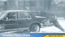
• Hello, please take a minute to check out our awesome content, contributed by the wonderful members of our community. We hope you'll add your own thoughts and opinions by making a free account!

Wintry Winters Last Stand / March 11th-13th Winter Storm

raw
talk about snow chase, lol
 
Paris,Tennessee received over 3 inches of snow this morning in Henry County. Got about a half inch here at my house. Looking forward to seeing how this afternoon and tonight plays out.
 
We'll soon be within range of the HRRR in the Carolinas. Here's the last few runs of the HRRRX, slightly less snow on the new run, but yea even at 6z, this model completely botched the snow near and just west-northwest of Nashville so take it w/ a massive grain of salt...

Old run, note again how it busted horribly even a few hours out from not picking out the snow near and northwest of Nashville. In fact, even up to 6z the experimental HRRR showed no snow in Nashville. Whoops.
acsnw_t6sfc_f35.png
acsnw_t6sfc_f32.png
 
Havent heard from olhausen. I wonder how his area is faring since he is not far from Nashville

Woke up to a pleasant surprise this morning. This is one of the rare occasions that Nashville and southern areas are doing better then my area due to the heaviest precip being further south. Maybe tonight will bring more surprises!

6c014573f49671a30d917d26a55534ed.jpg


fa8b8da2f8624fa8ae046b8bd28d302f.jpg


Sent from my iPad using Tapatalk
 
Tennessee seems to be in as good of a shape as I thought they possibly would be, but unfortunately there is (or I should say was) a bit of a dry area that's north of Nashville. I see that olhausen did get a dusting though this morning!
 
So for the times I called the way this system was playing out weird on the models, it kinda looks like it's going to play out similar to the NAM in which this wave is going to have breaks in it. There's another round that you can see on the radar that will probably hit later.

Just wonder if it will fill out later today and tonight like the NAM has shown... But even if it doesn't, some areas in East TN, just going by radar returns seem like they're going to hit 2-3" of snow, and this isn't even in the mountains.
 
I was pumped with the 6z runs

Sent from my SM-G928V using Tapatalk
6z was just enough to give me hope but the 12z took it back....only thing I'm really hanging onto is Nashville getting snow, North of any forecast model but I'm really not feeling it

Sent from my SM-G920V using Tapatalk
 
Definitely having some flashbacks to Feb 11 2014 here in Fayetteville (& pts south)... Granted this storm is a little different w/ more moisture being blocked by the Appalachians and won't last nearly as long, but I think you get the idea. Only expected an inch or so, picked up about 3-4", while those to my east in New Bern received as much as 10". Nuts.

SE US radar Feb 11 2014 7am.gif
February 11 2014 NC Snowmap.gif
 
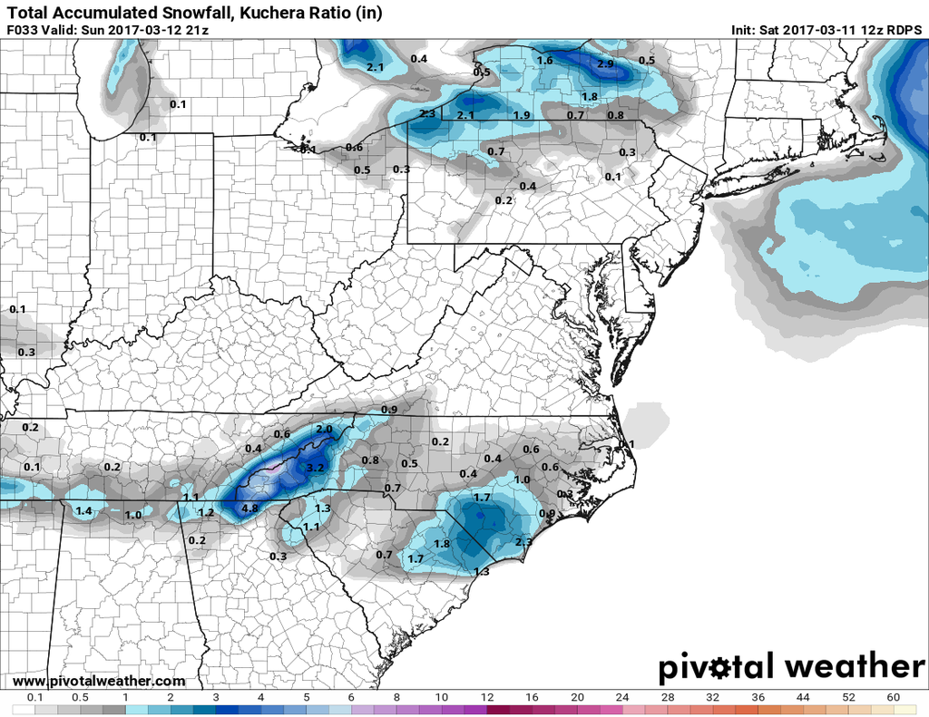
Actually just saw the 06z RGEM was a tad better but either way there has been an ever so slight north shift....maybe enough I see flakes fly.

Sent from my SM-G920V using Tapatalk
After what you went through a couple weeks or so ago, you deserve it! Here's hoping!!
By the way, how's your Mom doing?
Best - Phil
 
Definitely will be quite a bit of sublimation across the Carolinas tonight w/ dew points in the singly digits, but that should allow areas esp from Fayetteville and points south to wet bulb below freezing once legit precip arrives. 2-3"+ is certainly achievable as extra Atlantic moisture gets involved somewhere between Fayetteville, Florence/Darlington, & Wilmington
 
After what you went through a couple weeks or so ago, you deserve it! Here's hoping!!
By the way, how's your Mom doing?
Best - Phil
She's doing great, getting out and about, walking everyday...coming right along thanks. I'm hoping for a few token flakes but not expecting any

Sent from my SM-G920V using Tapatalk
 
Here's what the WPC is saying in regards to the Monday/Tuesday system and model solution they're preferring (emphasis mine):

MODEL DIFFERENCES WITH THE SHORTWAVE TROUGH BEGIN AROUND 36 HOURS
AND BEYOND AS THE 12Z NAM BECOMES A TAD SLOWER THAN THE MODEL
CONSENSUS AS THE SYSTEM ADVANCES ACROSS THE MID MS/OH VALLEYS. THE
00Z CMC FOR ITS PARTS APPEARS TO BECOME JUST A TAD WEAKER. THE 12Z
GFS/00Z ECMWF AND 00Z UKMET ARE BETTER CLUSTERED. AS SECONDARY LOW
PRESSURE DEVELOPS OFF THE SOUTHEAST COAST AND LIFTS NORTHEAST UP
OFF THE EASTERN SEABOARD...THE 12Z NAM IS OVERALL THE WEAKEST AND
FASTEST SOLUTION...AND IS ALSO FARTHEST LEFT/WEST WITH THE LOW
TRACK. THE 12Z GFS IS ONLY A LITTLE SLOWER BUT IS FARTHER
RIGHT/EAST WITH ITS LOW TRACK. THE 00Z UKMET/00Z CMC AND 00Z ECMWF
ARE ALL COLLECTIVELY A BIT SLOWER AND TRACK THEIR RESPECTIVE LOWS
GENERALLY A LITTLE LEFT OF THE GFS...ESPECIALLY RELATIVE TO THE
MID-ATLANTIC REGION. THERE IS A BIT BETTER CLUSTERING WITH THE GFS
RELATIVE TO THE LOW TRACK INVOLVING NEW ENGLAND...BUT THE GFS
AGAIN IS FASTER THAN THE NON-NCEP MODELS. AT THIS TIME POINT...THE
NAM IS AN OUTLIER SOLUTION AND WILL NOT BE PREFERRED
. ACCOUNTING
FOR SOME FASTER TREND SEEN IN THE GFS...AND THE CONSISTENCY OF THE
ECMWF AND UKMET...A BLEND OF THE GFS/UKMET AND ECMWF WILL BE
PREFERRED.
 
Temps went above freezing very quickly and melted all my snow. I'm sure even places that got much more are seeing thier snow melt very fast.:(
Hey - You got some!!!! More power to you!!!!!!! ;) (turnin' that frown upside down !!!!) :)
 
Back
Top