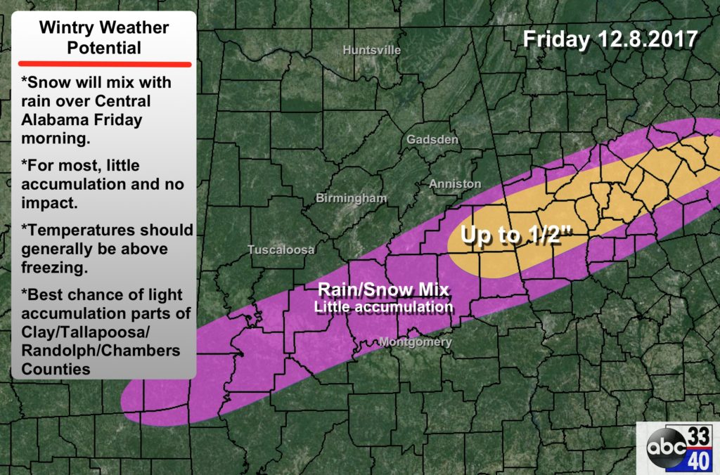
I think the last couple of days before yesterday, totals had been diminished , especially the farther east you got from TN! TN had a 1-2" bubble, everything from there E, was " up to an 1""I hope last night's system isn't a sign of what's to come as far as the amount of precip
Sent from my SM-G920V using Tapatalk
-
Hello, please take a minute to check out our awesome content, contributed by the wonderful members of our community. We hope you'll add your own thoughts and opinions by making a free account!
You are using an out of date browser. It may not display this or other websites correctly.
You should upgrade or use an alternative browser.
You should upgrade or use an alternative browser.
MotoWeatherman
Meteorologist
It's actually not that far off when you look at the NAM composite versus surface reflectivity.

https://postimg.org/image/xp1zy4f6d/
https://postimg.org/image/xp1zy4f6d/
Interesting note is that the Nam is already underestimating the precip


accu35
Member
Hes being safe for now, lol. Could get more out of it, the sweet spotsSpann map
NAM looks a little colder so far with first push of moisture.
accu35
Member
I agreeNAM looks a little colder so far with first push of moisture.
packfan98
Moderator
Looks a lot drier through MS, AL, GA so far (hr 29)
accu35
Member
Looks more juiced up hr 30
RollTide18
Member
Looks more juiced up hr 30
Low also a tick west than it was at 0z
accu35
Member
This could get good if that NW movement continues. Or precip shield
MotoWeatherman
Meteorologist
NAM is way drier on Thursday...it's come back to earth so far. On to Friday.
Would be good for getting colder/dryer air to settle in!?NAM is way drier on Thursday...it's come back to earth so far. On to Friday.
RollTide18
Member
NAM going dry on us, lets see what the rest of the model does
MotoWeatherman
Meteorologist
Current 12z NAM...

6z NAM...

6z NAM...
Yeh idk how you can say the NAM is West. Nothing reflects that lol
NorthGaWinter4
Member
Looks the same as the last two runs to me
going to have to see if it produces anything late Thursday into Friday am. Looks a bit warm at 850...BL looks better and heavy precipitation rolling through AL And GA mainly south of I-20
accu35
Member
I agree it looks the same. First wave breaks up before second wave, at least thats what been shown on hereLooks the same as the last two runs to me
NAM is underreporting precip. Shows no rain this morning for ATL area BUT....
Here is the live radar view as of 9am:


Here is the live radar view as of 9am:
still looks a bit too warm, in areas that have precipitation falling at hour 39
NW /N edge definitely not as far N as 6z! Noticeably
accu35
Member
Second wave starting to move now hr 39.
Webberweather53
Meteorologist
NAM is underreporting precip. Shows no rain this morning for ATL area BUT....
Here is the live radar view as of 9am:
Some of that precipitation is likely virga over portions of north-central Alabama and the finger of reflectivity protruding towards the metro. Also have to keep in mind w/ base reflectivity, the beam height increases w/ disturbance away from the radar site so as you look further away from Atlanta towards say Alabama you're actually looking up higher aloft where it is raining harder than at the surface
Storm5
Member
Yeah not sure what the issue is . The wave that will produce is just getting going on the 12z bam. Moving NE out of the gulfSecond wave starting to move now hr 39.
accu35
Member
Snow breaking out south texas
Webberweather53
Meteorologist
The entire trough base in the NAM is becoming less positively tilted as this emerges from Texas w/ the southern stream disturbance speeding up relative to previous 2 runs and the longwave trough axis and accompanying northern stream disturbances slowing down.

accu35
Member

MotoWeatherman
Meteorologist
Not necessarily. It's just finally getting a clue on the Thursday wave.
Would be good for getting colder/dryer air to settle in!?
WeatherWatch
Member
It's looking like it will be another hit on the 12z NAM.
accu35
Member

RollTide18
Member
This one is gonna be a good one
WXinCanton
Member
ATL about to get nailed looks like.
Here comes the surge north at 51...
Webberweather53
Meteorologist
The NAM is trending towards a more intense storm, the trough axis becoming less positively tilted, the upper level jet juxtaposition looks to be improving over the last few runs and the gulf low is stronger this time by a couple mb


RollTide18
Member
The NAM is trending towards a more intense storm, the trough axis becoming less positively tilted, the upper level jet juxtaposition looks to be improving over the last few runs and the gulf low is stronger this time by a couple mb
Somebody is gonna get warm nosed
accu35
Member
Some heavy rates i imagine
Is that too far up?Somebody is gonna get warm nosed

RollTide18
Member

Should be a nice clown map
MotoWeatherman
Meteorologist
Very minor changes in the upper levels make all the difference at the surface. Like Webber stated the trough is less positive tilted and also a tad deeper across TX. This allows slightly more ridging ahead of it allow better moisture transport north on Friday.
12z NAM...

Vs...6z NAM...

12z NAM...
Vs...6z NAM...
Snowflowxxl
Member
ATL getting pounded