accu35
Member
I worked all night, but i got to stay up to see the gfs/cmc 12z. Maybe skip gfs go straight to cmc lol jk.
I don't know, they keep upping my imaginary totals from run to run. What could possibly be amiss? Besides the fact it would be improbable even in Jan., for me to get 11 inches, Lol. TYeah people take the clown maps at face value. They are way overdone
What will be will be. I don't think we get totally blanked. Just seeing snow fall at this stage of winter would be great.
Yeah people take the clown maps at face value. They are way overdone
Ill be happy to take my 3-5" range lolI woudn't use 10:1 ratios, I'd use 5:1. What you see on the 10:1 ratio snowfall output maps will be cut in half. So, where you see that 10" in Georgia on the 12z NAM, that would be more like 4 1/2" to 5." Now, if the models start to show higher rates, of course the ratios would go up.
Looks fine, a stronger cyclone will probably result in more CAA and intense backside snow on this storm which is virtually the only way you're getting snow in this.Hey Webb, for us south central Bama folks, are we sitting ok for now with this "potential" storm?
http://www.weather.gov/ffc/winter
I like the snowfall chances they have listed.Numbers keep growing.
please post lolI'll take the 12z rgem . Has an expansive precip shield

It only goes out to hour 48 . But it was headed for an amped system as wellplease post lol
DangParker this would work lol
Sent from my SM-J320VPP using Tapatalk
Webber, is there any update on that jet streak you mentioned the other day?


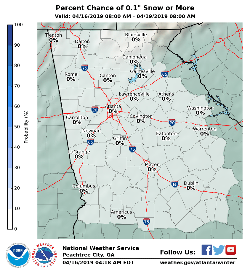
expected snowfall 0 everywhere?http://www.weather.gov/ffc/winter
I like the snowfall chances they have listed.Numbers keep growing.

Scroll to the bottom of the page and you will see a table that details the percentages for different tiers of potential snowfall for various cities.expected snowfall 0 everywhere?

Parker this would work lol
Sent from my SM-J320VPP using Tapatalk
Takes a train with a load of snowI'll take the 12z rgem . Has an expansive precip shield
Lol aren't we all? Yeah we just need about a 50 mile shift. Hell if not , it's Friday and I'll be taking the familu SE of our area to find itWow, I would take that all day. It will be interesting to see these short range models now that we are getting close. I mean we are not asking for a huge shift. 50 miles or so and a more expanded precip shield may work out for us, but I am sometimes a major wishcaster.
The rgem is my favorite short term model. However the 48 hour rgem is like the 65 hour NAM. Its really good inside 24 hours But the 12z rgem run was headed for gloryHow well does the RGEM typically do?
What you meant to say was " I would not feel too confident in any significant snowfall atm south of Boston "I would not feel too confident in any significant snowfall atm southeast of Statesville, Grensboro, & Roxboro in central NC...
You are going to annoy Brick to no end with posts like this!I would not feel too confident in any significant snowfall atm southeast of Statesville, Grensboro, & Roxboro in central NC...