Basically no snow outside of Wilkesboro NC! Maybe a little more precip? But warmer6z gfs trended better, still not great
-
Hello, please take a minute to check out our awesome content, contributed by the wonderful members of our community. We hope you'll add your own thoughts and opinions by making a free account!
You are using an out of date browser. It may not display this or other websites correctly.
You should upgrade or use an alternative browser.
You should upgrade or use an alternative browser.
Psalm 148:8
Member
- Joined
- Dec 25, 2016
- Messages
- 345
- Reaction score
- 792
Ok... so I’ve been in the snow jackpot bullseye every model and run since yesterday... yet FFC and BMX continue to basically dismiss this event... with BMX going 1/2 inch accumulation. Good thing I’m not a forecaster... this is apparently an extremely difficult forecast...probably the 1/2 a degree makes all the difference forecast.
South AL Wx
Member
An important reminder from NWS BMX's discussion this morning:
"Have seen plenty of model snow accumulation maps floating around on
social media and elsewhere, but you can throw those algorithms and
10 to 1 ratios out the window in this situation given the warm
temperatures near the surface."
That said, they have added a low confidence for light accumulating snowfall in their HWO.
Yellow Snow
Member
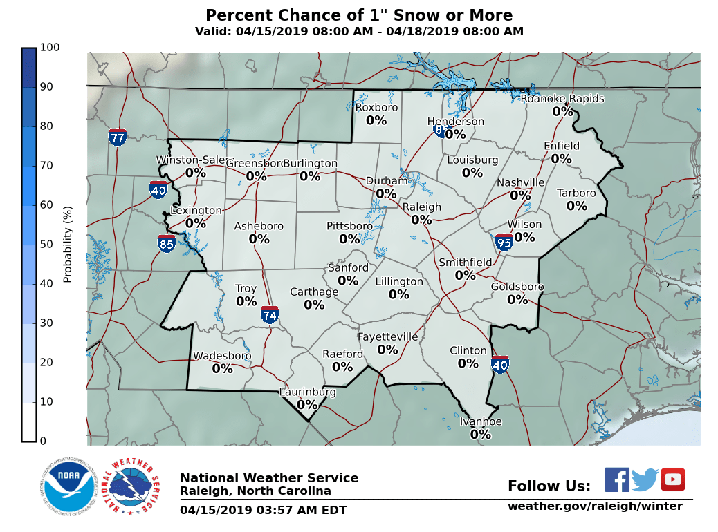
Latest 10% probability map from FFC, valid through 7:00am Saturday morning (remember that this is still an experimental product):

packfan98
Moderator
6z GEFS is by far the best run. Looks like more of a consensus with the best axis from about Burlington to Mebane and NE from there. Seems to match up with some of the other models.

packfan98
Moderator
FFC forecast has trended away from model consensus. In fact, they've taken snow out of the grids for Atlanta completely. Giving a 20% chance of light rain
packfan98
Moderator
Here's Matthew East's morning video. It's a great way to start your mornings and get caught up on the overnight model runs.
Smart move on their part. This is a rough period right here.FFC forecast has trended away from model consensus. In fact, they've taken snow out of the grids for Atlanta completely. Giving a 20% chance of light rain
They must have seen the 6z GFS? Not a good run for ATLFFC forecast has trended away from model consensus. In fact, they've taken snow out of the grids for Atlanta completely. Giving a 20% chance of light rain
The GFS runs have all been not good for ATL but last one was improvedThey must have seen the 6z GFS? Not a good run for ATL
Someone had said the GDPS has a 6z and 18z run as well. Here is the 6Z precip maps, the off hour runs only to 84 hours.


This is a tough one. As they all are in the SE. Honestly think NAM is out of touch, CMC likely too strong, GFS may come around? Euro more likely solution. Today's runs will be interesting.
6z GFS clearly made a move towards the other global models.
Showmeyourtds
Member
6z GFS clearly made a move towards the other global models.
Agree here. FFC is rejecting NAM for now in their updated discussion. Can’t say I blame them. They do still mention a chance for mixed precip in my grid for Friday Night, but only at 20%
That's not a bad mean at all, only problem for me personally is I think I'm losing this one to the NW trend. I've been in and around the jackpot since it started showing up on the models and the Euro currently still has me there but I guarantee you when it's all said and done this is an I-85 special6z GEFS is by far the best run. Looks like more of a consensus with the best axis from about Burlington to Mebane and NE from there. Seems to match up with some of the other models.
Sent from my SM-G920V using Tapatalk
I'm having a hard time getting way into the nw trend idea. I think there will be an larger NW edge to the precip shield but unless this goes full cmc I can't see a huge NW jump in the rn sn lineThat's not a bad mean at all, only problem for me personally is I think I'm losing this one to the NW trend. I've been in and around the jackpot since it started showing up on the models and the Euro currently still has me there but I guarantee you when it's all said and done this is an I-85 special
Sent from my SM-G920V using Tapatalk
Sent from my SM-G955U using Tapatalk
Models all underpredicted moisture for this morning significantly. Compare radar to model precip and reflectivity.
Well I hope you're right I was kind of thinking the same thing until I saw the CMC last night and look like to me that you GEFS had shifted somewhat NW. Old habits die hardI'm having a hard time getting way into the nw trend idea. I think there will be an larger NW edge to the precip shield but unless this goes full cmc I can't see a huge NW jump in the rn sn line
Sent from my SM-G955U using Tapatalk
Sent from my SM-G920V using Tapatalk
Yeah I mean we always seem some leaking toward the NW but I can't find a big catalyst to drive it way north at the last second like the January failure. Maybe I'm wishcastingWell I hope you're right I was kind of thinking the same thing until I saw the CMC last night and look like to me that you GEFS had shifted somewhat NW. Old habits die hard
Sent from my SM-G920V using Tapatalk
Sent from my SM-G955U using Tapatalk
Nah I think you're absolutely right unless this thing goes Bonkers bombs away I don't see it going too far north either and even at that looking at the upper levels there's only so far Northwest it could go.Yeah I mean we always seem some leaking toward the NW but I can't find a big catalyst to drive it way north at the last second like the January failure. Maybe I'm wishcasting
Sent from my SM-G955U using Tapatalk
Sent from my SM-G920V using Tapatalk
B
Brick Tamland
Guest
Euro still looking like those classic Raleigh area jackpots.
We always seem to forget, myself included, that come game time climo wins 99% of the time.That's not a bad mean at all, only problem for me personally is I think I'm losing this one to the NW trend. I've been in and around the jackpot since it started showing up on the models and the Euro currently still has me there but I guarantee you when it's all said and done this is an I-85 special
Sent from my SM-G920V using Tapatalk
Alex
Member
I was watching Matthew East's breakdown on YouTube this morning, the Euro solution he showed had RDU catching almost 5"!! I almost choked on my coffee.Euro still looking like those classic Raleigh area jackpots.
Sent from my XT1650 using Tapatalk
Models all underpredicted moisture for this morning significantly. Compare radar to model precip and reflectivity.
It always seems to when it comes to overrunning precip. HRRR has the precip moving into N.GA by 11am this morning and even it looks slightly underdone on the northern fringe of the precip that's out there in AL/MS right now. I honestly don't see how we make it into the upper 40s/near 50 today if we have precip moving in during the late morning/noon time today.
RollTide18
Member
I think from now until Friday, every view of the radar is important, seems like more moisture than the models advertised, maybe I'm looking at it wrong.
Shane I can see where your coming from. Same for metwannabe. We are so used to the NW trend. In this case you have flatter faster GFS vs slower stronger nam and cmc
I also think, to Webb points, tomorrow rain should help us out a bit too.
I think BL temps are still the biggest problem! I mean, your not gonna have the rates to overcome it, being on W/NW fringe and light rainI think from now until Friday, every view of the radar is important, seems like more moisture than the models advertised, maybe I'm looking at it wrong.
That's a great post. We are gonna need heavier rates to helpI think BL temps are still the biggest problem! I mean, your not gonna have the rates to overcome it, being on W/NW fringe and light rain
Will it matter if the temps are low-ishI also think, to Webb points, tomorrow rain should help us out a bit too.
But the humidity ( DPs) are close to temp with all the moisture around these next few days? Not much help with evaporational cooling!?
RollTide18
Member
I think BL temps are still the biggest problem! I mean, your not gonna have the rates to overcome it, being on W/NW fringe and light rain
That's also true, have to also watch out for reflectivity on radar, can't necessarily have light rain in this situation.
whatalife
Moderator
Ummm sref have increased for a lot areas since the the last run... I know they are poor indicators.
Sent from my iPhone using Tapatalk
Sent from my iPhone using Tapatalk
RollTide18
Member
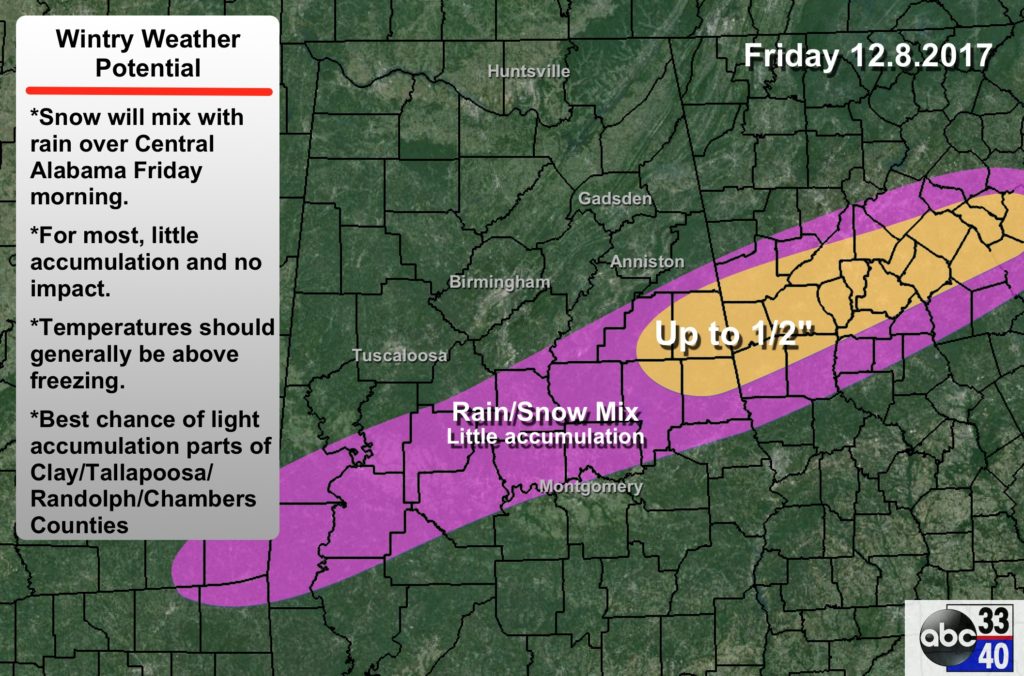
Spann map
We need some good runs today! Today is critical. Wouldn’t surprise me to see some big changes in either direction.
RollTide18
Member
We need some good runs today! Today is critical. Wouldn’t surprise me to see some big changes in either direction.
NAM not too far away
How close do we have to get , to get RAP'd?
dsaur
Member
This actually seems sensible, given all the maps, climo, et al. Goofy and climo say no, most everyone else says yes, so I'll go with yes, but within reason, lol. Oh, sure, I'd like to get 6 or 8 inches of snow, if it can't be sleet, but it's kind of pie in the sky, until I see it on my door step....or the next county over. TSpann map
RollTide18
Member
Interesting note is that the Nam is already underestimating the precip


I hope last night's system isn't a sign of what's to come as far as the amount of precip
Sent from my SM-G920V using Tapatalk
Sent from my SM-G920V using Tapatalk