Unfortunately no, it looks like it on the RMM charts but trop forcing will eventually settle around the Indian Ocean for a minute after the current MJO pulse leaves, which will set the pacific jet retraction in motion, can see it easily on VP charts Vs the RMM. Looks like we’ll have favorable MJO propagation again sometime around the 2nd-3rd week of January, and we might start seeing downwelling effects of the possible SSW coming up. It’s worth noting that while we may get into a -PNA pattern due tropical forcing, it’s also is what is likely gonna start a legitimate period of -NAO.Maybe there’s a chance the MJO does a loop in the COD and avoids the bad phases?
.png)
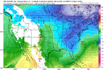
Basically my thinking.
week 1-1.5 of jan = favorable pattern, questionable cold, but we could make something happen, need certain things in the overall longwave pattern to go right (deep northern stream trough over the NE US/SE Canada, trailing wave(s) associated with wavebreaking from the GOAK longwave trough)
- Week 1.5-3 of jan might get mild/lackluster because the MJO will finally encourage -PNA/western troughing, which should kickstart a favorable Atlantic pattern
-week 3 of jan we make a favorable flip and probably see the most favorable pattern since January 2022