You get your best rates when it’s raining in RoxboroView attachment 130634
Living on the edge
-
Hello, please take a minute to check out our awesome content, contributed by the wonderful members of our community. We hope you'll add your own thoughts and opinions by making a free account!
You are using an out of date browser. It may not display this or other websites correctly.
You should upgrade or use an alternative browser.
You should upgrade or use an alternative browser.
Misc Winter 22-23 Whamby and Banter Thread Part 2
- Thread starter packfan98
- Start date
That is what the airport officially recorded for December, .1”I don't know but that shouldn't even count. 0.1 at least to be measured and at least an inch to be decent by their standards
Way less then I do and I’m only about 40 miles north of there. I’ve had 17” total since the 17-18 winter.I’m talking real snow. How often does Atlanta have a good snowstorm ?
Drizzle Snizzle
Member
It's quite remarkable how much more snow you get than downtown Atlanta despite being not that far away.Way less then I do and I’m only about 40 miles north of there. I’ve had 17” total since the 17-18 winter.
All our hopes hinge on Fab Feb at this point. ?
And we know how that usually works out!All our hopes hinge on Fab Feb at this point. ?
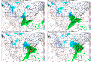
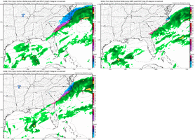
Completely skips South Carolina. Hard toss.next weekend
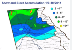
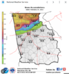
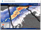
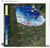
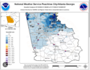
I would never consider living south of Atlanta just because of the lack of snow. A lot of the guys I work with live down in the McDonough area and are amazed at how much more snow I get.I decided to pull up some maps of some recent storms, and it is pretty wild.
View attachment 130636
View attachment 130637
2017
View attachment 130638
Feb 2020
View attachment 130639
2022
View attachment 130640
LukeBarrette
im north of 90% of people on here so yeah
Meteorology Student
Member
2024 Supporter
2017-2023 Supporter
bring back loganelliot…
NoSnowATL
Member
SnowNiner
Member
And we know how that usually works out!
February 26, 2004 used to be my go to storm to say, hey there's always February. But Februarys have been so bad and warm for so many years I've stopped expecting a storm (looking yes, I'm a weenie, but not expecting). January has been the deal, but I guess we hope for a break in the streak.
Hell, they way things have gone recently if it doesn’t snow in December then winter is a cancel according to a lot of people !February 26, 2004 used to be my go to storm to say, hey there's always February. But Februarys have been so bad and warm for so many years I've stopped expecting a storm (looking yes, I'm a weenie, but not expecting). January has been the deal, but I guess we hope for a break in the streak.
I love JB
Brent
Member
This whole climate change thing makes me laugh... Especially with how warm it's been lately. I decided to check the records the other day. Our all time January high is from 1909 and we didn't even get remotely close. What was warmth called back then?? In fact both the times Tulsa hit 80 in January was over 100 years ago
in my time tracking this stuff i have two recurring thoughts, "wow NW trend is real" and "metro atlanta is getting shafted, again" don't know how yall over there do itI decided to pull up some maps of some recent storms, and it is pretty wild.
View attachment 130636
View attachment 130637
2017
View attachment 130638
Feb 2020
View attachment 130639
2022
View attachment 130640
Luckily for me, I live at the end of the arrow, but I feel there is a bit of science to it.in my time tracking this stuff i have two recurring thoughts, "wow NW trend is real" and "metro atlanta is getting shafted, again" don't know how yall over there do it
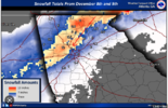
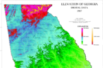
If you overlay these two maps, it might make sense, but what do I know.
NBAcentel
Member
Wen snow
smast16
Member
I'm sticking with what I said yesterday. Cutter, Cutter, sheared during our 4 day pattern change, if you can call it that, then back to ridge. This winter is awful
ajr
Member
I85 > I95


Hey next winter should be awesome though! El Nino coming on, if it can stay "weak" we good but If it's moderate to strong - just like this winter warm and very wet.............
call this pattern mariano rivera the way we cant get any hits against this constant stream of cutters
smast16
Member
I'm learning to find the silver lining in things. If it isn't snowing, at least it's warm enough to save some money on heating after Christmas. Lol.I'm sticking with what I said yesterday. Cutter, Cutter, sheared during our 4 day pattern change, if you can call it that, then back to ridge. This winter is awful
- Joined
- Jan 5, 2017
- Messages
- 3,775
- Reaction score
- 5,985
Yes! And, it's raining and 61 degrees here. Nice to remember this summer when it's 95 and a 5% chance of afternoon thunderstorms.I'm learning to find the silver lining in things. If it isn't snowing, at least it's warm enough to save some money on heating after Christmas. Lol.
- Joined
- Jan 5, 2017
- Messages
- 3,775
- Reaction score
- 5,985
Hey, at least it's not Cutter, tornadoes, cutter, tornadoes and then sheared and then on to warm and dry.I'm sticking with what I said yesterday. Cutter, Cutter, sheared during our 4 day pattern change, if you can call it that, then back to ridge. This winter is awful
NoSnowATL
Member
OVER
NoSnowATL
Member
Too early to start the spring thread?
I say do it. It will give people anxiety.Too early to start the spring thread?
Once again, the coldest day of the week is Saturday, the one day I have time to do all my outdoor work....... ugh
NoSnowATL
Member
Lick said he will help.Once again, the coldest day of the week is Saturday, the one day I have time to do all my outdoor work....... ugh
YayOnce again, the coldest day of the week is Saturday, the one day I have time to do all my outdoor work....... ugh
Heelyes
Member
Good grass painting weather
I prefer it that way. The work heats you up but below the threshold of sweating.Once again, the coldest day of the week is Saturday, the one day I have time to do all my outdoor work....... ugh
As long as it's dry this is correctGood grass painting weather
NoSnowATL
Member
Always remember to wet any surfaces like sidewalks, driveway and the exterior of the house. That ---- stains.As long as it's dry this is correct
I hate ---- stainsAlways remember to wet any surfaces like sidewalks, driveway and the exterior of the house. That ---- stains.
smast16
Member
That explains a lot, especially when reading your posts to certain users...??I hate ---- stains
NoSnowATL
Member
fixedGFS trying to throw ME a bone next weekend with a strong clipper, late bloomer off the coast....

