pcbjr
Member
Took away my 1st freeze, so it SUX ...Just checking in to see how the 18z GFS is working out for everyone...
Sent from my iPhone using Tapatalk

Oh, I just recalled how IMBY posts disturb me ...

Took away my 1st freeze, so it SUX ...Just checking in to see how the 18z GFS is working out for everyone...
Sent from my iPhone using Tapatalk


Complete chaos. Gotta get rid of that gigantic low in the Pacific.

 From the DT!
View attachment 7515 From the DT!
3 to 4 weeks away, so don't fret. DT loves it when anything looking good south of the NC border even appears like it may collapse ... Take it and him with a huge and bitter grain of salt ...December/mid December can't get here soon enough. Can we keep
Do the euro ensembles show us losing the greenland block the first week in December? Looks like from dts post...
Yeah, whatever gets Richmond/DCA snow, he’s good with! I think he’s bitter that the severely cold part of the Thanksgiving blast, is going to hit BOS/NYC hard, and not him3 to 4 weeks away, so don't fret. DT loves it when anything looking good south of the NC border even appears like it may collapse ... Take it and him with a huge and bitter grain of salt ...
Hell, he even thinks the entirety of the Civil War was fought in PA and VA ...
Off the soapbox before love shines brighter ...
Not sure, but we can’t have wall to wall cold!? Has to be a relaxation period, then the hammer drops Christmas-Feb!December/mid December can't get here soon enough. Can we keep
Do the euro ensembles show us losing the greenland block the first week in December? Looks like from dts post...
That’s the plan, time to be thankful December isn’t a torch like last year. ( as of now)Not sure, but we can’t have wall to wall cold!? Has to be a relaxation period, then the hammer drops Christmas-Feb!
I will take another torchy December if it includes another historic snowstorm.That’s the plan, time to be thankful December isn’t a torch like last year. ( as of now)
December/mid December can't get here soon enough. Can we keep
Do the euro ensembles show us losing the greenland block the first week in December? Looks like from dts post...
Any winter with a historic snowstorm is a win, IMOI will take another torchy December if it includes another historic snowstorm.
Not at all saying this year is like a 09-10, but I believe I remember that year, models kept trying to break the blocking down. And it just kept coming back.
 A new 384 hr threat! This one has legs!
Euro threat #1. Euro caved to the GFS, doesnt tear down the ridge. Now if we can get the southern wave a smidge faster.
.png")
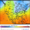
There are a few (~3-4) EPS members that produce >1" of snow in central-eastern NC when that s/w comes eastward around day 8-10.
View attachment 7522
.png")
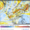
Hey Webber I know it's too early to say but does Alabama and Mississippi areas have a chance during this time frame?Whatever storm we got in this timeframe would probably be Miller type-A/coastal low in the Carolinas unless more North Pacific blocking appears between now & verification.
View attachment 7523
Hey Webber I know it's too early to say but does Alabama and Mississippi areas have a chance during this time frame?