May get close to seeing the first shot fired by the Euro.
-
Hello, please take a minute to check out our awesome content, contributed by the wonderful members of our community. We hope you'll add your own thoughts and opinions by making a free account!
You are using an out of date browser. It may not display this or other websites correctly.
You should upgrade or use an alternative browser.
You should upgrade or use an alternative browser.
Wintry Winter 2018-19 Discussion
- Thread starter Snowfan
- Start date
LovingGulfLows
Member
- Joined
- Jan 5, 2017
- Messages
- 1,499
- Reaction score
- 4,100
I remember hoping for the NW trend during the storm that battered Savannah/Charleston last year and it never happened. That being said, I love the very tall western ridge being modeled by the GFS ensembles. The ridge near Greenland is also very nice.
Very interesting look on the Euro. At 168hrs both Euro and FV3 have a very similar look. However the Euro then dampens the ridge out west and allows a powerful SW to break off the Aleutian low into the west coast. The FV3 does not, and while the model shows nothing, 500mb screams a big time threat.
Should be very interesting to see the result and what may be our first significant threat time frame.
Should be very interesting to see the result and what may be our first significant threat time frame.
B
Brick Tamland
Guest
I was wondering if it would be better to post on the November thread now instead of this one since everyone seems to be talking about specific model runs and threats now instead of overall thoughts on winter. It seems the pre-game show is over, and it's game time now!
pcbjr
Member
Nice way to potentially end the month and start the next ...


MAYDAY! Plenty of cold where it needs to beView attachment 7502 Classic pre SE snowstorm look right there!!
Kylo
Member
Such big differences in the pacific day 7-8+ with the GEFS/EPS.

Storm5
Member
just a little ...... is feel a lot better if they were switched around. Day 7/8 isn’t that far off . I hardly ever bet against the EPS
Sent from my iPhone using Tapatalk
18z GFS isn't looking promising,
just a little ...... is feel a lot better if they were switched around. Day 7/8 isn’t that far off . I hardly ever bet against the EPS
Sent from my iPhone using Tapatalk
I'll bet against the EPS every time. Yes I'm still ill.
That being said it, the 18z GFS has a 561dm ridge north of the Hudson. Crazy.
toss18z GFS isn't looking promising,
Good luck storm hunting beyond 168hrs or so. The OPs go nutty like crazy trying to resolve this. Incredible weather pattern setting up.
Going to toss the 18z. It looks like crap
whatalife
Moderator
Just checking in to see how the 18z GFS is working out for everyone...
Sent from my iPhone using Tapatalk

Sent from my iPhone using Tapatalk
ForsythSnow
Moderator
Complete chaos. Gotta get rid of that gigantic low in the Pacific.

pcbjr
Member
Welcome to weather ...Complete chaos.

~~~~~~~~~
It'll settle down, and then someone somewhere will be happy and someone else somewhere will be sad ... so enjoy the uncertainty and know in your heart of hearts that the someone sad lives way outside this neck of the world ...
NoSnowATL
Member
November 19Welcome to weather ...
~~~~~~~~~
It'll settle down, and then someone somewhere will be happy and someone else somewhere will be sad ... so enjoy the uncertainty and know in your heart of hearts that the someone sad lives way outside this neck of the world ...
pcbjr
Member
Precisely. You extrapolate exceedingly well ...November 19
Jessy89
Member
I’m not so sure many people score the first week of December. Perhaps mid December be better.
Something is missing!?? Oh yeah, that giant +PNA ridge! That escalated quickly!Complete chaos. Gotta get rid of that gigantic low in the Pacific.
pcbjr
Member
Took away my 1st freeze, so it SUX ...Just checking in to see how the 18z GFS is working out for everyone...
Sent from my iPhone using Tapatalk
Oh, I just recalled how IMBY posts disturb me ...
Kylo
Member
So far through Nov 17th the pattern is very similar to the previous Nov snowy/cold nino composites. For Dec the composites show npac low more east then we like but retrogrades west into Jan/Feb. Thus temps get progressively colder. In short, I like where we are. (knock on wood)


Complete chaos. Gotta get rid of that gigantic low in the Pacific.
I think the stranger thing is that it has three very powerfull ULLs exerting influence over NA.
 From the DT!
SnowNiner
Member
December/mid December can't get here soon enough. Can we keep
Do the euro ensembles show us losing the greenland block the first week in December? Looks like from dts post...
View attachment 7515 From the DT!
Do the euro ensembles show us losing the greenland block the first week in December? Looks like from dts post...
pcbjr
Member
3 to 4 weeks away, so don't fret. DT loves it when anything looking good south of the NC border even appears like it may collapse ... Take it and him with a huge and bitter grain of salt ...December/mid December can't get here soon enough. Can we keep
Do the euro ensembles show us losing the greenland block the first week in December? Looks like from dts post...
Hell, he even thinks the entirety of the Civil War was fought in PA and VA ...
Off the soapbox before love shines brighter ...
Yeah, whatever gets Richmond/DCA snow, he’s good with! I think he’s bitter that the severely cold part of the Thanksgiving blast, is going to hit BOS/NYC hard, and not him3 to 4 weeks away, so don't fret. DT loves it when anything looking good south of the NC border even appears like it may collapse ... Take it and him with a huge and bitter grain of salt ...
Hell, he even thinks the entirety of the Civil War was fought in PA and VA ...
Off the soapbox before love shines brighter ...
Not sure, but we can’t have wall to wall cold!? Has to be a relaxation period, then the hammer drops Christmas-Feb!December/mid December can't get here soon enough. Can we keep
Do the euro ensembles show us losing the greenland block the first week in December? Looks like from dts post...
NoSnowATL
Member
That’s the plan, time to be thankful December isn’t a torch like last year. ( as of now)Not sure, but we can’t have wall to wall cold!? Has to be a relaxation period, then the hammer drops Christmas-Feb!
I will take another torchy December if it includes another historic snowstorm.That’s the plan, time to be thankful December isn’t a torch like last year. ( as of now)
Jon
Member
December/mid December can't get here soon enough. Can we keep
Do the euro ensembles show us losing the greenland block the first week in December? Looks like from dts post...
No and yes.
That screenshot is from the weeklies which does have a neutral NAO by Dec 6...but that’s hour 370-400 or so. I wouldn’t put much weight into that. However, what he’s pointing out is the deep negative anomalies for the EC trough. Usually a sign of a storm. Very impressive negative anomalies for so far out.
Sent from my iPhone using Tapatalk
cd2play
Member
Any winter with a historic snowstorm is a win, IMOI will take another torchy December if it includes another historic snowstorm.
Not at all saying this year is like a 09-10, but I believe I remember that year, models kept trying to break the blocking down. And it just kept coming back.
SnowNiner
Member
Not at all saying this year is like a 09-10, but I believe I remember that year, models kept trying to break the blocking down. And it just kept coming back.
I certainly hope so. I'm sure we can have a decent winter without it, but the blocking is what has me excited.
 A new 384 hr threat! This one has legs!
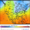
Webberweather53
Meteorologist
Euro threat #1. Euro caved to the GFS, doesnt tear down the ridge. Now if we can get the southern wave a smidge faster.
There are a few (~3-4) EPS members that produce >1" of snow in central-eastern NC when that s/w comes eastward around day 8-10.
.png")
Last edited:
Webberweather53
Meteorologist
There are a few (~3-4) EPS members that produce >1" of snow in central-eastern NC when that s/w comes eastward around day 8-10.
View attachment 7522
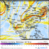
Whatever storm we got in this timeframe would probably be Miller type-A/coastal low in the Carolinas unless more North Pacific blocking appears between now & verification.
.png")
Ilovesnow28
Member
Hey Webber I know it's too early to say but does Alabama and Mississippi areas have a chance during this time frame?Whatever storm we got in this timeframe would probably be Miller type-A/coastal low in the Carolinas unless more North Pacific blocking appears between now & verification.
View attachment 7523
Webberweather53
Meteorologist
Hey Webber I know it's too early to say but does Alabama and Mississippi areas have a chance during this time frame?
No idea on who or if this threat would even materialize I'm just stating generally speaking if one comes to fruition, the planetary-scale pattern we have in place supports coastal lows or perhaps an overrunning event. I've generally noticed it's hard to get big cold air damming events w/o significant North Pacific blocking seeding the continent and northern stream waves w/ frigid Siberian air and getting split flow upstream in the eastern Pacific.