The snowfall analysis from that map is prototype data. So, it may not be accurate for some area's. I do believe it includes ice/sleet accumulations as well. But don't hold my word on that, I could be wrong.Upstate SC hasn’t had any snow. Maybe some ice in the Spartanburg area from that system last week but idk about .1-1”. Am I missing something?
-
Hello, please take a minute to check out our awesome content, contributed by the wonderful members of our community. We hope you'll add your own thoughts and opinions by making a free account!
You are using an out of date browser. It may not display this or other websites correctly.
You should upgrade or use an alternative browser.
You should upgrade or use an alternative browser.
Wintry Winter 2018-19 Discussion
- Thread starter Snowfan
- Start date
whatalife
Moderator
Well the Euro Weeklies look much better as we move towards the end of December and into January. #whatashocker
Sent from my iPhone using Tapatalk
Sent from my iPhone using Tapatalk
MichaelJ
Member
Here is the EURO latest winter forecast, it is almost identical to Weatherbell's Pioneer model
Round Oak Weather
Member
If we couldn’t score more than a few times down here then I think I would be a little agitatedHere is the EURO latest winter forecast, it is almost identical to Weatherbell's Pioneer model
ghost1
Member
Is there any hope for a pattern flip in January? For everyone west of the Carolinas... I'm thinking this might go down as "the winter that wasn't"
NoSnowATL
Member
Yes don’t give up, please remember most of the SE doesn’t even see snow until Jan.Is there any hope for a pattern flip in January? For everyone west of the Carolinas... I'm thinking this might go down as "the winter that wasn't"
NoSnowATL
Member
This was always going to be a backloaded winter. This December storm pattern we have been in the last few years is interesting but don’t change anything.
Round Oak Weather
Member
Honestly the highest snowfall totals in georgia at least my are seen to be February and March. February 1973 March 1993 March 2009 February 2010. January seems to have the more powdery snowYes don’t give up, please remember most of the SE doesn’t even see snow until Jan.
JB is on the VERY COLD side going forward!! (No surprise) 
Major cold evolving for January.
Don't want to rush the core of cold in.
The threat of most severe cold will be for January 15-February 15 when normals are lowest.
During that time the average of Chicago, NYC, Dallas and Atlanta could reach -10°F or greater for at least a week.
Benchmark for lowest temperatures is 0°F in NYC, -10°F in Chicago, 15°F at Dallas and 10°F in Atlanta.
Feedback from threats of repetitive snow events can enhance the cold.
First of all drying is spreading back into the area of the Indian Ocean in Days 4-11 that tipped us off to the current warmth when it was wet.
Here is the EURO latest winter forecast, it is almost identical to Weatherbell's Pioneer model
Dang, how did I miss this? This is far colder than the prior run and is actually the coldest yet for the SE overall of what I’ve seen though it is about the same as the prior coldest for far southern posters like Phil though even he is currently solidly cold on this. This is the first run showing the -40 to -60 meter color anywhere in the SE, which means posters in N GA, N AL, TN, upstate SC, NC, VA, KY, and IN are much colder than in any other Euro outlook:
Last month’s most disappointing run: https://southernwx.com/community/threads/winter-2018-19-discussion.410/page-27#post-116649
Sep run:
https://southernwx.com/community/threads/winter-2018-19-discussion.410/page-9#post-105502
Aug run:
https://southernwx.com/community/threads/winter-2018-19-discussion.410/page-2#post-103582
I can’t find the Oct run.
Edit: Considering the slightly warmer than average to near normal Dec we will end up with, IF this run were to verify for DJF overall, OMG!
Last edited:
Oh JB, for once I wish you could be right! I’ll buy you a 55 gallon drum of bubble bath if this comes true!JB is on the VERY COLD side going forward!! (No surprise)
Major cold evolving for January.
Don't want to rush the core of cold in.
The threat of most severe cold will be for January 15-February 15 when normals are lowest.
During that time the average of Chicago, NYC, Dallas and Atlanta could reach -10°F or greater for at least a week.
Benchmark for lowest temperatures is 0°F in NYC, -10°F in Chicago, 15°F at Dallas and 10°F in Atlanta.
Feedback from threats of repetitive snow events can enhance the cold.
First of all drying is spreading back into the area of the Indian Ocean in Days 4-11 that tipped us off to the current warmth when it was wet.
Temps so far this young Season:
Greensboro: November ( -4.2) December: Up till 19th ( -1.6)
Raleigh: November ( -3.3) December: Up till 19th ( -1.1)
Greensboro: November ( -4.2) December: Up till 19th ( -1.6)
Raleigh: November ( -3.3) December: Up till 19th ( -1.1)
ghost1
Member
GFS finally showing some cold air punching a little deeper into south central CONUS at the end of midday run. Maybe a signal for a pattern flip?
On a positive note BTR has not hit the 70s since 12/2. So although no extreme cold so far this winter, at least no extreme heat. And the average temps are BN.
Some DJF 2018-9 anomalies vs normal:
0 Dallas: the big winner!
+2 Memphis, RAH, GSP
+3 Fayetteville, Columbia, Wilmington, Waycross
+4 Huntsville, Birm., Florence, CHS, SAV, ATL, Macon, Chat., Asheville, Jacksonville. Jackson
+5 Nashville, Montgomery, GNV, Augusta
0 Dallas: the big winner!
+2 Memphis, RAH, GSP
+3 Fayetteville, Columbia, Wilmington, Waycross
+4 Huntsville, Birm., Florence, CHS, SAV, ATL, Macon, Chat., Asheville, Jacksonville. Jackson
+5 Nashville, Montgomery, GNV, Augusta
Not as bad as I thought actuallySome DJF 2018-9 anomalies vs normal:
0 Dallas: the big winner!
+2 Memphis, RAH, GSP
+3 Fayetteville, Columbia, Wilmington, Waycross
+4 Huntsville, Birm., Florence, CHS, SAV, ATL, Macon, Chat., Asheville, Jacksonville. Jackson
+5 Nashville, Montgomery, GNV, Augusta
Not as bad as I thought actually
Yeah ,the CAD regions of NC/SC did better due to the numerous wedges. And Memphis and especially Dallas were far away from the SER's warm influences.
NBAcentel
Member
Decided it was time to start the thread. With the El Nino expected to develop in the fall, it looks it could be a good winter for us.

NBAcentel
Member
SER, pacific air, bad version of the -EPO, MJO ruined this winter
DJF 2018-9 anomalies in graphic form: warning this may be too graphic for the faint of heart! But in all seriousness, you can see that Brent was the big winner being far from the SER, AR to Memphis and vicinity weren’t that warm, and that much of NC into NW SC didn’t do that bad thanks to numerous wedges:

Last edited:
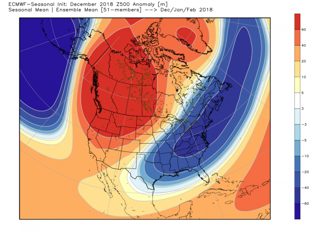
Now compare the above pic of the actual warm winter with the Euro DJF forecast issued in Nov: there couldn’t have been a worse bust for the entire country as it was warm where it was forecasted to be cold (E US) and it was cold where it was forecasted to be very warm (W US)(I still suspect the very warm Atlantic had a lot to do with the screw up):

Oh I don’t know...the Pioneer might be worse. Anyway, I’m going to go ahead and submit my winter forecast for next year. +3 to +7 across the entire SE with most of the region seeing 20% of their annual snowfall.Now compare the above pic of the actual warm winter with the Euro DJF forecast issued in Nov: there couldn’t have been a worse bust for the entire country as it was warm where it was forecasted to be cold (E US) and it was cold where it was forecasted to be very warm (W US)(I still suspect the very warm Atlantic had a lot to do with the screw up):
View attachment 17167
Cad Wedge NC
Member
Sad to say, you might be right.Oh I don’t know...the Pioneer might be worse. Anyway, I’m going to go ahead and submit my winter forecast for next year. +3 to +7 across the entire SE with most of the region seeing 20% of their annual snowfall.
ForsythSnow
Moderator
Pretty much an opposite for sure. What a disappointment this winter was. Onto the next seasons.Now compare the above pic of the actual warm winter with the Euro DJF forecast issued in Nov: there couldn’t have been a worse bust for the entire country as it was warm where it was forecasted to be cold (E US) and it was cold where it was forecasted to be very warm (W US)(I still suspect the very warm Atlantic had a lot to do with the screw up):
View attachment 17167