• Hello, please take a minute to check out our awesome content, contributed by the wonderful members of our community. We hope you'll add your own thoughts and opinions by making a free account!

Wintry Winter 2017-18 discussion

WxSouth sounds bullish on Facebook.

For the record, I'd lean cooler than average Southeast to Midwest. And very active precip wise in a good chunk of the Southeast and MidAtlantic for the 3 month period December through February, with snow and ice paying a visit much more often, and to many more areas of the Southeast, than it did either of the last 2 Winters.
 

Yeah, I can't take the NOAA maps too seriously. They have a good way to go for predicting a decently accurate winter forecast. One thing they like is an above average South that seems to show up a lot. Of course that happens more than a below average one, but missing half the country's anomalies is not good.
 
Yeah, I can't take the NOAA maps too seriously. They have a good way to go for predicting a decently accurate winter forecast. One thing they like is an above average South that seems to show up a lot. Of course that happens more than a below average one, but missing half the country's anomalies is not good.
You mean recent winters are more likely to be warmer, right? because that wouldn't be the case over many years or the average would be different.
 
I enjoy reading weather folklore and signs of Winter weather. Has anyone seen any signs from Mother Nature of an impending harsh winter? :cool:
 
Last edited:
Yeah, I can't take the NOAA maps too seriously. They have a good way to go for predicting a decently accurate winter forecast. One thing they like is an above average South that seems to show up a lot. Of course that happens more than a below average one, but missing half the country's anomalies is not good.

Here's how I did vs reality last winter... Not too bad. Ironically, in spite of producing one of the warmest winter forecasts, I still ended up being too cold lol.
https://ncwxmichaelmugrage.weebly.com/blog/category/winter-weather-outlook-20162017

Screen Shot 2017-10-22 at 10.54.09 AM.png

cd2606-a000-1500-8005-9176-f67b-b834-ade9.294.8.58.39.prcp.png
 
Here's how I did vs reality last winter... Not too bad. Ironically, in spite of producing one of the warmest winter forecasts, I still ended up being too cold lol.
https://ncwxmichaelmugrage.weebly.com/blog/category/winter-weather-outlook-20162017

View attachment 1430

View attachment 1431
I would be interested as well as many others as to what your idea is on winter later on. You were close last year as you said, so maybe this year you will be as well. The issue with last year was that convection and a bad QBO from what it sounds like, which could mean that we won't be 80 at Christmas and 70s through January. We had abd winters in 2012 and 2013, and the last two were horrible, so maybe we could have our break finally this year.
 
I enjoy reading weather folklore and signs of Winter weather. Has anyone seen any signs from Mother Nature of an impending harsh winter? :cool:
I havnt seen the first wooly worm yet, probably been too warm for them to come out of the mountains!
Last year the fruit and berry crops ever super heavy and that winter was a torch. Not as heavy this year, so here's to hoping
 
I figure we're either going to stay warm and dry all winter, or the pendulum is going to swing back hard and it's going to be cold and with a lot of winter storm chances. Just seems our weather now is one of extremes, and the pattern holds on forever, and it takes something completely opposite to change it. Nothing seems "normal" anymore.
 
Good info from RAH NWS: had some good stuff on NAO cycles only lasting 20 days before changing/resetting; Anyway just passing along. In weak Lanina need to root for a -NAO. Duh!

Pattern Interactions

Global patterns do not occur independently; they occur on overlapping timescales, and have important interactions that can magnify or diminish the effects of an individual pattern.

For example, the warm (positive) phase of the ENSO cycle, better known as El Niño, typically results in a more active southern jet stream, which ultimately leads to increased precipitation across the southeastern U.S. during the winter. When a negative NAO is in place during an El Niño winter, cold, Arctic air is transported towards the southeastern U.S. with enhanced precipitation potential due to the El Niño effect, and research at the SCO has found that the number of snow days in NC increase significantly in all four winter months.

The chart below shows the average number of snow days (with ≥1 inch of snow) in central and eastern NC, broken down by NAO and ENSO phase.

NAO_Interactions.png


Our results found that a negative NAO combined with a positive ENSO phase (El Niño) resulted in the most snow days on average, with an increase of 25% (or more) in snow days for all four winter months.

A positive NAO combined with a negative ENSO (La Niña) resulted in the greatest decrease in average snow days. This is due to a lack of cold air (results of a typical positive NAO), and less active subtropical jet stream (results of a typical La Niña).

NAO had the most significant impact on snow days. Even in winter months that featured La Niña conditions (typically warm and dry), combined with a negative NAO, only February saw a decrease in snow days, which suggests that the NAO has a more direct influence on NC snowfall than ENSO. The reason behind this is that the NAO directly impacts the large scale atmospheric pattern over the eastern U.S. on a daily timescale, whereas the ENSO pattern indirectly effects the eastern U.S. atmospheric pattern by altering global circulations, and does so on monthly to seasonal timescales.

This is interesting stuff. While it confirms that a - nao is needed for significant snowa +nao actually produces more snow days. I guess a lot can be said for front end hits to rain or snow to mix. These stats should make people feel a little better about +nao and la niña. It might not snow a foot but odds are snow will fall

Sent from my SM-G955U using Tapatalk
 
Last edited:
Good info from RAH NWS: had some good stuff on NAO cycles only lasting 20 days before changing/resetting; Anyway just passing along. In weak Lanina need to root for a -NAO. Duh!

Pattern Interactions

Global patterns do not occur independently; they occur on overlapping timescales, and have important interactions that can magnify or diminish the effects of an individual pattern.

For example, the warm (positive) phase of the ENSO cycle, better known as El Niño, typically results in a more active southern jet stream, which ultimately leads to increased precipitation across the southeastern U.S. during the winter. When a negative NAO is in place during an El Niño winter, cold, Arctic air is transported towards the southeastern U.S. with enhanced precipitation potential due to the El Niño effect, and research at the SCO has found that the number of snow days in NC increase significantly in all four winter months.

The chart below shows the average number of snow days (with ≥1 inch of snow) in central and eastern NC, broken down by NAO and ENSO phase.

NAO_Interactions.png


Our results found that a negative NAO combined with a positive ENSO phase (El Niño) resulted in the most snow days on average, with an increase of 25% (or more) in snow days for all four winter months.

A positive NAO combined with a negative ENSO (La Niña) resulted in the greatest decrease in average snow days. This is due to a lack of cold air (results of a typical positive NAO), and less active subtropical jet stream (results of a typical La Niña).

NAO had the most significant impact on snow days. Even in winter months that featured La Niña conditions (typically warm and dry), combined with a negative NAO, only February saw a decrease in snow days, which suggests that the NAO has a more direct influence on NC snowfall than ENSO. The reason behind this is that the NAO directly impacts the large scale atmospheric pattern over the eastern U.S. on a daily timescale, whereas the ENSO pattern indirectly effects the eastern U.S. atmospheric pattern by altering global circulations, and does so on monthly to seasonal timescales.
Well, a couple of years ago we had that combo that gave Raleigh the most number of snow days on average, and that's why everyone was calling for a lot if snow that winter. We don't even get to average. That's why I say what happened in the past and the indicies that are supposed to give us a lot if snow here doesn't seem to apply anymore.
 
This is interesting stuff. While it confirms that a - nao is needed for significant snowa +nao actually produces more snow days. I guess a lot can be said for front end hits to rain or snow to mix. These stats should make people feel a little better about +nao and la niña. It might not snow a foot but odds are snow will fall

Sent from my SM-G955U using Tapatalk
Actually, they said you did a -nao with La Nina to get snow here.

NAO had the most significant impact on snow days. Even in winter months that featured La Niña conditions (typically warm and dry), combined with a negative NAO, only February saw a decrease in snow days
 
Last edited by a moderator:
Actually, they said you did a -nao with La Nina to get snow here.

NAO had the most significant impact on snow days. Even in winter months that featured La Niña conditions (typically warm and dry), combined with a negative NAO, only February saw a decrease in snow days

Yep, even in a favorable pattern, Februarys during La Ninas (like this year) are typically hot garbage
 
^I've found a good number of major NC snowstorms actually occurred during a +NAO. So, imo, how much a -NAO helps in the SE US is way overrated based on what has actually occurred.
At best, I think there is a weak correlation.
 
^I've found a good number of major NC snowstorms actually occurred during a +NAO. So, imo, how much a -NAO helps in the SE US is way overrated based on what has actually occurred.

Yes it definitely is... What I've found in a general sense is while it may not have a very profound effect on total snow in some cases, the sign of the NAO and/or EPO has a huge impact on the type of winter storm that can occur in the respective regime. When we have a very substantial -EPO/WPO (as we've seen the past several years), Miller B/overrunning events are favored and should be anticipated, whereas w/ a -NAO, very strong coastal lows (Miller As) are relatively more prominent especially from the Carolinas and points north.
 
Yeah, after 2014-2015 winter was such a bust, I don't think the indicies are reliable as they used to be for what actually happens here with regards to winter storms.
 
Last edited by a moderator:
Again, (& as I mentioned last winter) while the indices in general aren't reliable for wintry weather here in NC, they're actually very reliable for predicting the kind of winter storm we can expect here (if the pattern supports one). The most profound Miller A and B events of the 21st century only highlight this relationship between teleconnections and storm type in NC further...

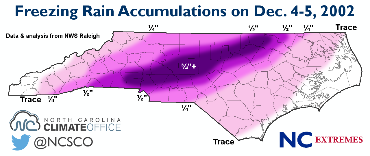
As mentioned earlier, Miller B/overrunning events are most often observed to occur in conjunction w/ North Pacific blocking (-EPO/-WPO) and what a surprise, look at the overall 500mb pattern during the devastating Dec 2002 ice storm...
Yes, while the NAO was positive, note how prominent the -EPO was during this event...
compday.PzydeqWoax.gif
infographic-2002_ice_storm.png


On the other hand, check out the 500mb pattern during the January 2000 snowstorm, one of the most classic Miller A events in the historical record for the Carolinas... There's a substantial -NAO but the North Pacific blocking that was prominent in the Dec 2002 ice storm is practically nonexistent.
compday.BiFzqbH76h.gif
accum.20000125.gif


In essence, yes we certainly can't completely rely on the sign one teleconnection or the other to have a strong, linear relationship to wintry weather here in the Carolinas, but there's an unmistakable relationship on where the high latitude blocking is located and whether or not we end up with an ice storm, or large coastal low w/ a sharp rain/snow line...

Generally speaking, -EPO/-WPO favors Ice storms while -NAOs are more conducive to coastal lows
 
Further to the above about how much a -NAO is overrated for major SE snow chances. I just compiled for the first time ever the NAO for all 21 Raleigh 6"+ SN/IP storms since 1950. (I'm calling neutral NAO to be from +0.25 to -0.25):

-1/19/1955: -NAO
- 12/11/1958: neutral NAO
- 3/2-3/1960: neutral NAO
- 3/9/1960: neutral NAO
- 2/26/1963: neutral NAO
- 1/25-7/1966: -NAO
- 2/9/1967: +NAO
- 3/1/1969: -NAO
- 1/7-8/1973: -NAO
- 2/18-9/1979: neutral NAO
- 3/1-2/1980: +NAO
- 1/13-14/1982: neutral NAO
- 3/24/1983: neutral NAO
- 2/6/1984: +NAO
- 1/7-8/1988: +NAO
- 2/17-8/1989: +NAO
- 1/24-5/2000: -NAO
- 1/2-3/2002: -NAO
- 2/26-7/2004: -NAO
- 12/25-6/2010: -NAO
- 2/24-6/2015: +NAO

Tally:
-NAO: 8 (38%)
Neutral NAO: 7 (33%)
+NAO: 6 (29%)


Not included in the above tally but an honorable mention since Raleigh didn't get heavy snow from it but many others did: 3/12-3/1993 Storm of the Century: +NAO

Conclusion: With results like this and a pretty nice sized sample, I feel one has to conclude that any correlation of -NAO with heavy SE US SN/IP is negligible at best.
 
Last edited:
Further to the above about how much a -NAO is overrated for major SE snow chances. I just compiled for the first time ever the NAO for all 21 Raleigh 6"+ S/IP storms since 1950. (I'm calling neutral NAO to be from +0.25 to -0.25):

-1/19/1955: -NAO
- 12/11/1958: neutral NAO
- 3/2-3/1960: neutral NAO
- 3/9/1960: neutral NAO
- 2/26/1963: neutral NAO
- 1/25-7/1966: -NAO
- 2/9/1967: +NAO
- 3/1/1969: -NAO
- 1/7-8/1973: -NAO
- 2/18-9/1979: neutral NAO
- 3/1-2/1980: +NAO
- 1/13-14/1982: neutral NAO
- 3/24/1983: neutral NAO
- 2/6/1984: +NAO
- 1/7-8/1988: +NAO
- 2/17-8/1989: +NAO
- 1/24-5/2000: -NAO
- 1/2-3/2002: -NAO
- 2/26-7/2004: -NAO
- 12/25-6/2010: -NAO
- 2/24-6/2015: +NAO

Tally:
-NAO: 8 (38%)
Neutral NAO: 7 (33%)
+NAO: 6 (29%)


Not included in the above tally but an honorable mention since Raleigh didn't get heavy snow from it but many others did: 3/12-3/1993 Storm of the Century: +NAO

Conclusion: With results like this and a pretty nice sized sample, I feel one has to conclude that any correlation of -NAO with heavy SE US SN/IP is negligible at best.
Larry,
Sitting down here on SW 13th Street, on the lake, and should not be looking, but am ... :eek:
Any idea on the PNA set-ups on any of those?
Best!
Phil
 
Larry,
Sitting down here on SW 13th Street, on the lake, and should not be looking, but am ... :eek:
Any idea on the PNA set-ups on any of those?
Best!
Phil

I just did a similar tally for PNA for the 21 individual 6"+ SN/IP storms at Raleigh since 1950 (I'm calling +0.25 to -0.25 neutral PNA):

+PNA: 10 (48%)
Neutral PNA: 8 (38%)
-PNA: 3 (14%)

Not included in the above tally but an honorable mention since Raleigh didn't get heavy snow from it but many others did: 3/12-3/1993 Storm of the Century: neutral PNA

Conclusion: I think one has to conclude that there's a good chance that there is a stronger correlation between a +PNA and a heavy SE snowstorm than a -NAO and the same. At the minimum, I'd much rather have either a +PNA or neutral PNA than a -PNA for heavy SE snow chances since 18 of the 21 (19 of 22 if include 3/1993) had either of those.

Edit: Addendum: the only 3 -PNA big RAH SN/IP were the two in March of 1960 and 2/24-26/2015, and the 2/24-6/2015 storm was only borderline -PNA. So, RAH went nearly 55 years between getting -PNA big snowstorms!
 
Last edited:
I just did a similar tally for PNA for the 21 individual 6"+ SN/IP storms at Raleigh since 1950 (I'm calling +0.25 to -0.25 neutral PNA):

+PNA: 10 (48%)
Neutral PNA: 8 (38%)
-PNA: 3 (14%)

Not included in the above tally but an honorable mention since Raleigh didn't get heavy snow from it but many others did: 3/12-3/1993 Storm of the Century: neutral PNA

Conclusion: I think one has to conclude that there's a good chance that there is a stronger correlation between a +PNA and a heavy SE snowstorm than a -NAO and the same. At the minimum, I'd much rather have either a +PNA or neutral PNA than a -PNA for heavy SE snow chances since 18 of the 21 (19 of 22 if include 3/1993) had either of those.

Edit: Addendum: the only 3 -PNA big RAH SN/IP were the two in March of 1960 and 2/24-26/2015, and the 2/24-6/2015 storm was only borderline -PNA. So, RAH went nearly 55 years between getting -PNA big snowstorms!

Very interesting (says me, Sgt. Schultz, here) ... and that does make me feel good, since even though it only snows in Gainesville when God is napping and therefore doesn't know, I've often and for a long time felt that the PNA is our local bus driver ... this gives me more confidence in my " 'sposin' " ...
Thanks, Larry!
Phil

YW. When I get more time, I plan to do AO and EPO. Now I'm really curious!
 
YW. When I get more time, I plan to do AO and EPO. Now I'm really curious!

For Raleigh 6"+ SN/IP since 1950:

AO: assuming neutral AO to be +0.5 to -0.5
6 -AO; 8 neutral AO, 7 +AO

3/1993 Storm of Century had +AO

So, little signal from AO, not too dissimilar to NAO's weak signal.

NAO/AO combo: Out of 21, 4 were -NAO/-AO and 4 were +NAO/+AO...so, little signal from the NAO/AO combo

EPO: (assuming neutral EPO +50 to -50)
Out of 21, 7 -EPO, 8 neutral, 6 +EPO
3/1993 Storm of Century had -EPO

So, little signal from EPO.

My conclusion: PNA is the #1 best indicator of PNA, NAO, AO, and EPO for major SE US snowstorms

Addendum: Storm of the Century 3/1993: neutral PNA, +NAO, +AO, -EPO
 
For Raleigh 6"+ SN/IP since 1950:

AO: assuming neutral AO to be +0.5 to -0.5
6 -AO; 8 neutral AO, 7 +AO

3/1993 Storm of Century had +AO

So, little signal from AO, not too dissimilar to NAO's weak signal.

NAO/AO combo: Out of 21, 4 were -NAO/-AO and 4 were +NAO/+AO...so, little signal from the NAO/AO combo

EPO: (assuming neutral EPO +50 to -50
Out of 21, 7 -EPO, 8 neutral, 6 +EPO
3/1993 Storm of Century had -EPO

So, little signal from EPO.

My conclusion: PNA is the #1 best indicator of PNA, NAO, AO, and EPO for major SE US snowstorms

Addendum: Storm of the Century 3./1993: neutral PNA, +NAO, +AO, -EPO
Every train has an engineer, a fireman, a brakeman and ... and a bus has a driver!
 
Every train has an engineer, a fireman, a brakeman and ... and a bus has a driver!

So, if I had to only pick one driver of the SE heavy snow bus, I'd easily pick the PNA to drive knowing that there's the small chance the PNA might be drunk and have a bad accident!

There's no telling whether or not any of the EPO, AO, and NAO bus drivers would get us there safely. Much more random!

My research for today is completed.

Edit: When i say PNA, I mean as long as it isn't the -PNA.
 
Last edited:
So, if I had to only pick one driver of the SE heavy snow bus, I'd easily pick the PNA to drive knowing that there's the small chance the PNA might be drunk and have a bad accident!

There's no telling whether or not any of the EPO, AO, and NAO bus drivers would get us there safely. Much more random!

My research for today is completed.
With you 1000% - no index drives the weather bus (hence the train analogy) - too many variables line up differently every year - but it's nice to see a personal and considered subjective observation get some numerical credence ... ;)
Thanks for the research and time, Larry!
Best!
Phil

PS - and looking down the track and around the bend, the fireman screams and the engine just gleams ...

pna.mrf.gif


4indices.png
 
Last edited:
PS - and looking down the track and around the bend, the fireman screams and the engine just gleams ...

pna.mrf.gif


4indices.png
[/QUOTE]

SMH! Where’s my suntan lotion.


Sent from my iPhone using Tapatalk
 
Greg Fishel is revealing his winter outlook tonight on the WRAL 6:00 newscast.
 
Back
Top