I noticed on the maps that, until this becomes better organized, the ridge to the north might help this go a bit more westerly?I'm not sure when the next flight is but the convection around the center has gotten its act together. I wouldn't be surprised if they upgraded without recon
-
Hello, please take a minute to check out our awesome content, contributed by the wonderful members of our community. We hope you'll add your own thoughts and opinions by making a free account!
You are using an out of date browser. It may not display this or other websites correctly.
You should upgrade or use an alternative browser.
You should upgrade or use an alternative browser.
Tropical TS Fred
- Thread starter GaWx
- Start date
Yeah weaker early is probably westI noticed on the maps that, until this becomes better organized, the ridge to the north might help this go a bit more westerly?

Notice the wave behind getting its act together
Also on mid level water vapor so far soon to be Fred has two stepped around the dry air tongue in front of it, avoided ingestion.

Also on mid level water vapor so far soon to be Fred has two stepped around the dry air tongue in front of it, avoided ingestion.
Short term= good cause shredder … long term= bad cause gulf warmthYeah weaker early is probably west
pcbjr
Member
There is a lot of dry air in front; the swirl is top stacked and storms are not forming/holding together underneath; as of yet no true lower level circulation; and it has a lot of shear in the front yard ... but hey, this is 2021 and anything is possible ... if not perhaps probable ...
“He was a midget in the big house, see? And he tried to escape by wiggling through a mouse hole after lights out, but he outsmarted himself, see? Cuz it wasn't a mouse hole, it was a light socket, and somebody turned the lights on.” -- Fred Flinstone, Season 2

“He was a midget in the big house, see? And he tried to escape by wiggling through a mouse hole after lights out, but he outsmarted himself, see? Cuz it wasn't a mouse hole, it was a light socket, and somebody turned the lights on.” -- Fred Flinstone, Season 2
Last edited:
Brent
Member
Still no Fred. Not sure what the NHC is waiting for
pcbjr
Member
For that wave to actually close and have a coc ...Still no Fred. Not sure what the NHC is waiting for
Fred is the best-looking "tropical wave" I may have ever seen.
Then you must not remember the Super Caribbean Cruiser wave of he late 2000’s.
Why does this thing have to head towards Atlanta now! ??? sigh
See, when you get old like me, a fading memory can be a good thing. I get to watch movies for the second and third time and they're like brand new!Then you must not remember the Super Caribbean Cruiser wave of he late 2000’s.
Brent
Member
For that wave to actually close and have a coc ...
Maybe but it seemed on the morning recon they didn't really fly where there could have been a center
It just is interesting because other times they rush to name stuff so fast...
At least we have PTC's now that helps with the warnings regardless so the whole naming thing is more about semantics
Recon is heading to PTC 6. Should be able to see if it has a closed circulation.
BHS1975
Member
HWRF looks bad for S Florida.
Sent from my iPhone using Tapatalk
Sent from my iPhone using Tapatalk
Tornadocane
Member
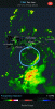
Check out Puerto Rico's radar. This is way further north than anyone suspected.
San Juan radar says this thing has some issues
Ya this thing still looks messySan Juan radar says this thing has some issues
Looks like the center is south of the radar site. Looks a bit north and moving almost due west. Looks like it's trying to get better organized.
JHS
Member
Hopefully it comes straight up the spine of the mountains from GA and northeast. That's the only way we will get good rain here. Storms today missed us.
pcbjr
Member

Ya if anything is at the sfc it's near that circle.
pcbjr
Member
.jpg")
.jpg")
New advisory has it now at 40 mph.
Henry2326
Member
18z HWRF trend comparison to 12z. Weaker and further south.

Stormsfury
Member
still can't find a well defined LLC. It's extremely close.. the wave axis is already tilting more NNW/SSE
Henry2326
Member
18z HWRF second landfall.......slower and weaker 12z but same general area.

Henry2326
Member
18z Euro.....looks similar to 18z HWRF
BHS1975
Member
18z Euro.....looks similar to 18z HWRF
The one behind it has a dry air shield.
Sent from my iPhone using Tapatalk
Brent
Member
Breaking news we have a center
URNT12 KNHC 110125 CCA
VORTEX DATA MESSAGE AL062021
A. 11/00:40:40Z
B. 17.34 deg N 066.30 deg W
C. 850 mb 1504 m
D. 1009 mb
E. 050 deg 6 kt
F. NA
G. NA
H. 35 kt
I. 006 deg 31 nm 00:31:00Z
J. 115 deg 40 kt
K. 038 deg 66 nm 00:20:00Z
L. 25 kt
M. 274 deg 8 nm 00:43:00Z
N. 043 deg 31 kt
O. 291 deg 77 nm 01:01:00Z
P. 17 C / 1532 m
Q. 19 C / 1526 m
R. 7 C / NA
S. 134 / 8
T. 0.02 / 6.5 nm
U. AF302 0206A SURVEY OB 11 CCA
MAX FL WIND 43 KT 038 / 71 NM 00:19:00Z
MAX FL TEMP 19 C 352 / 8 NM FROM FL CNTR
0 likes
Brent
Member
We have Fred
TROPICAL STORM FRED FORECAST/ADVISORY NUMBER 6
65 mph at the end of the forecast approaching the Panhandle
TROPICAL STORM FRED FORECAST/ADVISORY NUMBER 6
65 mph at the end of the forecast approaching the Panhandle
Brent
Member

GFS is a bit west of 18z @96 hours.
It’s gonna end up going into LA and MSGFS is a bit west of 18z @96 hours.
I thought it was but it has it like this:
.gif")
It’s gonna end up going into LA and MS
Brent
Member
Almost looks like an eyewall trying to form but Hispaniola awaits tomorrow

You forgot Shettley. Check out the bullseye in the upstate
Judging by how poorly it looks on IR means it will be hard to track before long. I doubt the current llc survives Hispaniola.