• Hello, please take a minute to check out our awesome content, contributed by the wonderful members of our community. We hope you'll add your own thoughts and opinions by making a free account!

Hurricane Debby

Probably going to be stronger than shown on models! Good call there!

Not much of any stronger looking at globals. Dry air is gonna be a big strengthening problem, especially around landfall. Even if it comes off the coast off GA, dry air may keep it strengthening much again.
 
NHC is worst case scenario. Better to prepare than be sorry. But I’m not forecasting those amounts gonna leave my final call as is with UKMET/Climo blend.
 
Not much of any stronger looking at globals. Dry air is gonna be a big strengthening problem, especially around landfall. Even if it comes off the coast off GA, dry air may keep it strengthening much again.
I still could see high end cat 1 , low end cat 2 at landfall.
 
I thinking around 85-90mph for landfall in FL. It should definitely intensify, however that constant dry air feed from the NW should limit anything crazy.

As we know Beryl was about the same and strengthening into landfall. We saw how bad that storm was. So, hopefully not stronger than 85-90. This will likely be bad enough as it is, including the expected massive rainfall.

For my area and vicinity, I’m hoping the very highly anomalous loop back NW into the lower SC or GA coast doesn’t actually occur. The GFS through 6Z (along with a significant % of GEFS members) is still doing this after many runs. And the 0Z CMC was kind of similar.

However, the 0Z/6Z Euro ops abandoned this craziness with the way more common progressive trek up the coast and thus kept rainfall from being as excessive as that for the crazy runs that backed in. The 0Z/6Z EPS still had some crazy members but not as many as earlier runs. So, keeping fingers crossed and will see what 12Z runs show. When I see something on models that’s essentially not happened on record for >170 years (Easy of 1950 was sort of similar though) it gives me lots of hope it won’t actually happen despite the chance for a first time occurrence.
 
As we know Beryl was about the same and strengthening into landfall. We saw how bad that storm was. So, hopefully not stronger than 85-90. This will likely be bad enough as it is, including the expected massive rainfall.

For my area and vicinity, I’m hoping the very highly anomalous loop back NW into the lower SC or GA coast doesn’t actually occur. The GFS through 6Z (along with a significant % of GEFS members) is still doing this after many runs. And the 0Z CMC was kind of similar.

However, the 0Z/6Z Euro ops abandoned this craziness with the way more common progressive trek up the coast and thus kept rainfall from being as excessive as that for the crazy runs that backed in. The 0Z/6Z EPS still had some crazy members but not as many as earlier runs. So, keeping fingers crossed and will see what 12Z runs show. When I see something on models that’s essentially not happened on record for >170 years, it gives me lots of hope it won’t actually happen despite the chance for a first time occurrence.
What are you thinking? Euro/ICON vs. GFS for the win?
 
What are you thinking? Euro/ICON vs. GFS for the win?
It’s going to be a last minute call. Models have initialized weaker than recon info , especially with Beryl, and the ridging is peculiar to say. I’m not betting on any model at the moment but it’s hard to argue with the NHC, tweaks will come but it’s close to landfall in FL. Just my opinion!
 
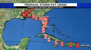
Oh man, this thing is reminding me of my wedding at Jekyll Island and Tropical Storm Fay 2008. That thing was forecast to ride up the east coast but stalled in Jacksonville for days and then hooked a left back West unexpectedly. We called it wedding day Fay lol. Our rehearsal was supposed to be a laua by the pool and instead was a epic hurricane party. It sat for days and left the morning of our wedding (blessed!)
1000002028.jpg
 
Last edited:
What are you thinking? Euro/ICON vs. GFS for the win?

With 170+ years of history backing the Euro/ICON, the 2 most recent Euros backing off, and the ICON/UKMET not having the NW turn back into the coast (UK has done this on no runs and ICON only on the 0Z 8/3 run that backed NW to between CHS and Beaufort), I’m currently going with Euro/ICON.
 
With 170+ years of history backing the Euro/ICON, the 2 most recent Euros backing off, and the ICON/UKMET not having the NW turn back into the coast (UK has done this on no runs and ICON only on the 0Z 8/3 run that backed NW to between CHS and Beaufort), I’m currently going with Euro/ICON.
To add, GFS seems to always forecast a stouter block than actually occurs.
 
Oh man, this thing is reminding me of my wedding at Jekyll Island and Tropical Storm Fay 2008. That thing was forecast to ride up the east coast but stalled in Jacksonville and then hooked a left back West unexpectedly. We called it wedding day Fay lol. Our rehearsal was supposed to be a laua by the pool and instead was a epic hurricane party. It sat for days and left the morning of our wedding (blessed!)
View attachment 149346

I need to reiterate that I still haven’t yet found any storm that had a LF into NW FL from the Gulf, then went offshore the SE coast, and then turned around and went NW back into N FL, GA, or SC. I didn’t include Fay of 2008 because she went into SW FL from the Gulf rather than into NW FL (N of Tampa). And Easy of 1950 didn’t quite make it to the Atlantic before backing NW. I’m still rechecking to make sure I didn’t miss any.
 
Back
Top