Mmm from memory this one is a touch colder.
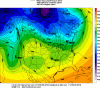
Here are dew points on gfs for this current storm
View attachment 10188
That’s probably 10 degrees drier across the board to start than December was.
But at 850s and 2m temps it’s not really substantially different.
December: View attachment 10190
This storm:
View attachment 10189
Overall the air mass is mildly drier than December. But not much overall temp change. One could ague this setup is warmer in VA, but colder further north.
Thank you!
I remember things like “decaying high pressure” and “rotting” being thrown around everywhere in early December. That airmass wasn’t really a big supernatural one. This one is fresh off the Polar Express but as others have said it’s not in the most ideal of positions
In this case, it may be so that the fresher nature of the air mass offsets the less than favorable HP location, allowing the end result to be similar to the December event. Still a lot to be decided.