Frame this one LOL I think i've found a new profile pic

What’s the ground truth to that?Frame this one LOL I think i've found a new profile pic
Lots of small flakes swirling around, moderate to heavy rainWhat’s the ground truth to that?
Most weather outlets saying pure snowWeird, you must have a pocket of a close 0c isothermal sounding above you atm


Hickory reporting .4" of ice accrual. Forsyth County has over 30,000 without power.
Correct. The roads are fine, but the ice on the trees and power lines have caused downed trees and the power outages.Note that both Hickory and Winston-Salem (in Forsyth County for those who don’t know) had all hourly readings of 31-32 during all of the ZR. The point is that it doesn’t normally take upper 20s to get a major accrural just above the ground though it sometimes takes that for the streets to get really bad. A good number of the worst ATL icestorms had 30-31 and even up to as high as 32 in a few cases. Some of this knowledge is from personal experience.
.jpg")
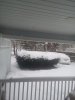
I'm no expert on freezing rain...but I'm guessing the icicle formations probably don't count on the official accrual count, but it seems to me they add quite a bit of weight.
I don’t think they count explicitly as the accrural would be much higher. My understanding is that typical accrurals are often in the 0.4 to 0.5 ratio to ZR that falls in rain gauges as much of the rest drips to the ground immediately, especially if heavy. Anyone know how much ZR has actually fallen at Winston-Salem and the accrurals there so we could see the ratio? Also, I saw per Packfan that Hickory got a whopping 0.40” accrural. Anyone know how much ZR fell in the gauge there?
https://w1.weather.gov/data/obhistory/KHKY.html
There is a 3 day history link on the point and click forecast pages from NWS.
We (Roanoke) busted low overnight fortunately! .28 instead of at least .75 that every model I looked at said we would get. as late as even the 00 hi res stuff.

Some returns up your wayAll in..... Lol
Yeah I see, dont think they make here however and not sure upper levels support snow yet either. Coastal low developing nicely though winds gusting in the 20's now..... brrrSome returns up your way
Sent from my SM-G955U using Tapatalk