D
Deleted member 1449
Guest
Actually already have glaze forming on car/trash can lid.
Enjoy lights while you can... 34 rn/ip mix now, fun while it lastedActually already have glaze forming on car/trash can lid.
Stuck between 33.7-33.8 here. Kinda knew it but also know that sometimes wedges will do tricky things so was holding out hope. Game over for us at least.33.4 and 99% humidity now. As you can guess it's not going to go lower. No ice this time again I'm sure.
So my stiff NE winds are the result of what? Not being smart just wondering.Agreed. The fetch of cold and dry look like they have been cut.
Maybe but I still don't foresee (at least me) dropping all the way to 32.0. I'm at 33.4.33.1 now still with 99% humidity. Must be some colder and slightly drier air coming in still.
We tried33.7/31 - light rain (my DP is dropping slowly)
Most of the official obs I'm seeing from NE GA have been easterly essentially all day, with a dewpoint steadily rising. Certainly no advection of colder, drier air into the region.So my stiff NE winds are the result of what? Not being smart just wondering.
Looks live we’ve got sleet on a tight sliver all the way down into Greenwood per WYFF local radaryes, brisk winds here out of the NE/ENE

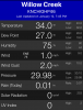
Close but doubtful my friend. Who knows at this pointMy weather station conditions
Sent from my SM-G955U using Tapatalk
I hope it dont. I don't want ice!Close but doubtful my friend. Who knows at this point
what is your location?33.1/30. Dropping about .4 an hour
Augusta road. That is what the closest weather station is showing.what is your location?

You closer to the actual city of Greenville or further north?33.4/31
He is just south of DT Greenville.You closer to the actual city of Greenville or further north?
Maybe mine is off a touch. 32.7/3033.4/31 - light rain