BufordWX
Member
Nice!
yeah, enhanced echo tops were between 30-40kft today.. 40kft seemed to be the threshold needed for enough charge separation to produce some CG lightning strikes.. very typical summertime convection "play-by-play" on the meso-gamma scale. No interesting outflow boundaries interactions to note of around here, or at least from what I noticed. However, tracked a ENE-NE moving outflow boundary that did the typical pop-up short-lived cells along the boundary.. ultimately screwing some areas.. my point tho is, it ruined the chances we had with storms tracking ESE.. moving them directly in the cold pool behind the boundary mentioned above. Nowcasting is fun for summertime convection, IMO. Lots of surprises but arguably more disappointments. Were used to that right, lols.


You are in a great spot this time. I am going to be too far south. Going to have to hope something happens here tomorrow.Picked up 0.42” from that storm earlier may get some more. 1.93” for the month
0.7 and counting. Also thisYou are in a great spot this time. I am going to be too far south. Going to have to hope something happens here tomorrow.
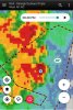
Well let's see what actually develops today. The 3k makes a little more sense with the W-E oriented band out in front of the disturbance and the trailing N-s band on the south side. Looks like the chances tomorrow has storms is increasing along and S of 64


FIELD GOAL!Nice little bow developing... oh wait, there's a giant hole in the middle, and I'm going right down the middle.
View attachment 85234
If a 750 mile wide tropical system came out of the gulf an went over GSP, you’d still get 0 rain4 separate storms within 5 miles and we get maybe a trace. Places less than a mile away probably over 1 inch and counting now. It is obvious to me that that we will have a very dry summer here. Storms just keep finding ways to miss and it'll be this way all summer. Hopefully the tropical system in the long range comes through GA and the Carolinas.

My curse was lifted for one night!!!!Nice little bow developing... oh wait, there's a giant hole in the middle, and I'm going right down the middle.
View attachment 85234

Your welcome ! Love to see it .My curse was lifted for one night!!!!
View attachment 85236
And I finally got to see the new gutter drain pipe working and see a dry basement!


That’s literally all I ask for at night but can’t seem to get onceCall the money line..hammer...down
View attachment 85239
Sorry man plenty of summer to go though. Once we recover from the front next week I think you have plenty of chancesThat’s literally all I ask for at night but can’t seem to get once