Yes, but in all fairness they’re back to showing December niño like they were last weekend. Late but not deniedRemember when just a few cycles ago things were looking better for cold? Boy, those were the days, huh?
-
Hello, please take a minute to check out our awesome content, contributed by the wonderful members of our community. We hope you'll add your own thoughts and opinions by making a free account!
You are using an out of date browser. It may not display this or other websites correctly.
You should upgrade or use an alternative browser.
You should upgrade or use an alternative browser.
Pattern The Great December Dump
- Thread starter Rain Cold
- Start date
packfan98
Moderator
And now the GFS may be setting up for a big winter storm for 12/28...Remember when just a few cycles ago things were looking better for cold? Boy, those were the days, huh?

SnowNiner
Member
Probably going to be right here.
What's so bad about the pattern? -AO, -NAO, split flow, and 50/50 PV, cold on our side of the globe. Looks to hang around. I know the Pacific is not the greatest, we need better ridging on the west coast, not the midwest, but still. You think we need the -EPO for better cold delivery to come back? That's the only thing that's missing IMO.
Without the Pacific all the NAO will do is block up mild air. Not sure about the EPO as it's hard to get a -NAO and -EPO. But a +PNA on the west coast would be a must.What's so bad about the pattern? -AO, -NAO, split flow, and 50/50 PV, cold on our side of the globe. Looks to hang around. I know the Pacific is not the greatest, we need better ridging on the west coast, not the midwest, but still. You think we need the -EPO for better cold delivery to come back? That's the only thing that's missing IMO.
SnowNiner
Member
Without the Pacific all the NAO will do is block up mild air. Not sure about the EPO as it's hard to get a -NAO and -EPO. But a +PNA on the west coast would be a must.
50/50 low can deliver cold air too, but I agree the ridging on the west coast is beneficial as well.
tennessee storm
Member
Exactly ... the cold air would just be bottled up in Canada ...Without the Pacific all the NAO will do is block up mild air. Not sure about the EPO as it's hard to get a -NAO and -EPO. But a +PNA on the west coast would be a must.
Downeastnc
Member
Phasing can either help or hurt. It depends on where the phase happens. The 1993 storm we were playing around with yesterday phased too far west to help us farther east. We got mostly rain. The December 2000 martha focker storm phased too far east, and we got missed. In this case, we don't have any sort of an antecedent cold air mass in place. So a southern stream wave moving west to east by itself is not going to be enough. So, we need a northern stream vort to phase with the southern stream energy. That would cool the column just enough to support snow over the upper SE. If that doesn't happen, the way it looks now, we are all rain. And it needs to happen not too far north or west, or we rain.
Some of you got missed...some of us not so much.....
")
The current pattern could pay off if it holds up, you figure 1 in 5 chances pays off so eventually one of these storms will be far enough east to pay out...I am hoping about 150-200 miles off Hatteras
Webberweather53
Meteorologist
People are freaking out over a pattern like this?
Lol ok.
Most of us would kill to see this pattern coming knocking at our doorstep around Christmas. A pretty classic Miller A pattern is being shown here verbatim.
.png")
Lol ok.
Most of us would kill to see this pattern coming knocking at our doorstep around Christmas. A pretty classic Miller A pattern is being shown here verbatim.
NBAcentel
Member
some GEFS members look good with low placement, but like RC said we need phasing for CAA and thus snow, but i like that blocking
NBAcentel
Member
this that type of pattern where if things go right, you could get a nice big dog, especially if phasing occurs, easily get amped up storms with that -NAO, just the problem like always in the SE is cold, but we have days to figure that out
I mean.. this is still worth watching imo

Downeastnc
Member
People are freaking out over a pattern like this?
Lol ok.
Most of us would kill to see this pattern coming knocking at our doorstep around Christmas. A pretty classic Miller A pattern is being shown here verbatim.
View attachment 27967
Yeah all it takes is one little wave sneaking in and popping off at the right time for there to be a lot of win here....honestly I hate the storms that the models have for days and days in the 5-10 day range they always seem to trend away after several big dog runs etc....its those little sneaky ones the models are late to pick up that pay off at least it seems that way to me....also less stress with only 3-4 days worth of runs to fret over...
The CMC is better, it's just north. We need that energy to phase further south, so the low needs to be around TX or LA


\
\
People are freaking out over a pattern like this?
Lol ok.
Most of us would kill to see this pattern coming knocking at our doorstep around Christmas. A pretty classic Miller A pattern is being shown here verbatim.
View attachment 27967
But that's assuming the GEFS way out at the unreliable hour 312 is even close to being right. Look at the major changes that occurred much earlier in the run. That in itself makes this 312 hour map even less reliable than normal.
Might as well go full weenie and add the 850 temps!I mean.. this is still worth watching imo
View attachment 27968

Green is good, right?? ?
Green is good, right?? ?
You betcha!

But to add at least a modicum of substance, there is enough cold air nearby that a well-timed phase or even a well-placed/timed high would help northern areas.
Webberweather53
Meteorologist
Like the EPS has been faring any better inside day 10-12...But that's assuming the GEFS way out at the unreliable hour 312 is even close to being right. Look at the major changes that occurred much earlier in the run. That in itself makes this 312 hour map even less reliable than normal.
Yep. Active pattern.Like the EPS has been faring any better inside day 10-12...
Like the EPS has been faring any better inside day 10-12...
Yep, neither has been doing well.
Webberweather53
Meteorologist
But that's assuming the GEFS way out at the unreliable hour 312 is even close to being right. Look at the major changes that occurred much earlier in the run. That in itself makes this 312 hour map even less reliable than normal.
As for "major" changes that occurred earlier in the run, we're going towards a stronger +EPO as the TPV gets absorbed towards Alaska but the -NAO is also getting stronger at most if not all time steps, so this big -NAO later in the run isn't occurring by chance.

.png")
These trends in the GEFS also match the mean height pattern anomaly for the same period which means it's probably more legit than usual.

FWIW the 12z Navgem has a storm in the favorable position

850s say it's now snow though

Link if you want to play around with it
https://www.fnmoc.navy.mil/wxmap_cgi/cgi-bin/wxmap_DOD_area.cgi?area=nvg_conus&set=All
850s say it's now snow though
Link if you want to play around with it
https://www.fnmoc.navy.mil/wxmap_cgi/cgi-bin/wxmap_DOD_area.cgi?area=nvg_conus&set=All
Webberweather53
Meteorologist
As for "major" changes that occurred earlier in the run, we're going towards a stronger +EPO as the TPV gets absorbed towards Alaska but the -NAO is also getting stronger at most if not all time steps, so this big -NAO later in the run isn't occurring by chance.
View attachment 27975
View attachment 27971
These trends in the GEFS also match the mean height pattern anomaly for the same period which means it's probably more legit than usual.
View attachment 27973
Without a coherent tropical forcing signal (a nascent one in the Maritime Continent atm) there's no doubt though that this upcoming period thru virtually the end of December is going to be highly tumultuous and unpredictable. The fact that we're getting a negative NAO without any help whatsoever from tropical subseasonal forcing speaks volumes to how favorable our base state is for -NAO (for once). If we continue ticking towards a +EPO in the extended some warm spells would be abound but the northern & central US would likely bear the brunt of the warmth (anomaly wise)
Webberweather53
Meteorologist
The last 4 12z Euro runs have been a total gong show in the eastern US.
Gotta love the continuous flip-flopping from deathly cold to torch near the Great Lakes.

Gotta love the continuous flip-flopping from deathly cold to torch near the Great Lakes.
At least Florida and south Texas is modeled cold consistently. Most weather social media outlets never show them below average.
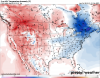
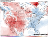
More thoughts about the 21st/22nd system. Looking at the GEFS, 500mb heights, it still shows a developing Gulf coastal low that eventually intensifies on the southeast coast.

850mb temp anomalies would support snowfall along and east of the Appalachian Mountains.

2m temp anomalies look to be marginal or slightly below during the 21st/22nd time window. I'd like to it trend colder, but the southeast can still score with snowfall with marginal temps.

Comparing the images above, the ridge over the Rockies would allow mild air to be in place just west of the Appalachian Mountains while the cold air is over Eastern Coast. So, if this were to hold true, there probably won't be much snowfall west of the mountains with the 21st/22nd system. Overall, I think most of the higher accumulating snowfall would be along and east of the Appalachian Mountains (again, if the 21st/22nd does bring snowfall.)
While I was looking over the 12z GEFS MSLP anomalies, I noticed a low develops down in the Caribbean on the tail end of a frontal boundary. This had thrown me off because the GEFS 500mb height anomalies chart does not show this feature. The MSLP anomaly doesn't even show the Gulf low that the GFS/GEFS has been showing. So, will the low develop and track on the Gulf coast? or develop over the Caribbean and intensify off of the southeast coast? Bottom line, the indications of a strong storm system intensifying off or on the southeast coast is present for next weekend. Will it be a snow storm, rain storm? we just don't know yet, but I still wouldn't completely write off a strong east coast snowstorm.


What do you all think about this?
850mb temp anomalies would support snowfall along and east of the Appalachian Mountains.
2m temp anomalies look to be marginal or slightly below during the 21st/22nd time window. I'd like to it trend colder, but the southeast can still score with snowfall with marginal temps.
Comparing the images above, the ridge over the Rockies would allow mild air to be in place just west of the Appalachian Mountains while the cold air is over Eastern Coast. So, if this were to hold true, there probably won't be much snowfall west of the mountains with the 21st/22nd system. Overall, I think most of the higher accumulating snowfall would be along and east of the Appalachian Mountains (again, if the 21st/22nd does bring snowfall.)
While I was looking over the 12z GEFS MSLP anomalies, I noticed a low develops down in the Caribbean on the tail end of a frontal boundary. This had thrown me off because the GEFS 500mb height anomalies chart does not show this feature. The MSLP anomaly doesn't even show the Gulf low that the GFS/GEFS has been showing. So, will the low develop and track on the Gulf coast? or develop over the Caribbean and intensify off of the southeast coast? Bottom line, the indications of a strong storm system intensifying off or on the southeast coast is present for next weekend. Will it be a snow storm, rain storm? we just don't know yet, but I still wouldn't completely write off a strong east coast snowstorm.
What do you all think about this?
Attachments
B
Brick Tamland
Guest
People are freaking out over a pattern like this?
Lol ok.
Most of us would kill to see this pattern coming knocking at our doorstep around Christmas. A pretty classic Miller A pattern is being shown here verbatim.
View attachment 27967
this that type of pattern where if things go right, you could get a nice big dog, especially if phasing occurs, easily get amped up storms with that -NAO, just the problem like always in the SE is cold, but we have days to figure that out
I think some are just looking for anything that could possibly go wrong. That's the nature of living here and enjoying snow. But to me it continues to look like we have a lot more to be optimistic about than usual for the remainder of the month if we want to get a winter storm. We have a good team out there, just have to see if they can win the game now.
Womp...That’s not what you want to see if you’re hoping for BN temps for the month of Dec.
Sent from my iPhone using Tapatalk

It was always suppose to be above normal so I’m not too bummed about it .. the chance it ends up below normal is just cool to trackWomp...That’s not what you want to see if you’re hoping for BN temps for the month of Dec.
Sent from my iPhone using Tapatalk
There are definitely more reasons to be optimistic about this winter than previous recent ones. I think that point has been pretty well made. But discussing the negative or what-could-go-wrong side, is part of the process as well. It's how you learn and how you get more accurate, if either of those are your goal. You like Greg Fishel. One of his primary rules in evaluating winter weather prospects around here was starting with what could go wrong. That is wise. Being negative just to be negative is as silly as being positive just to be positive. You're just wishcasting at that point.I think some are just looking for anything that could possibly go wrong. That's the nature of living here and enjoying snow. But to me it continues to look like we have a lot more to be optimistic about than usual for the remainder of the month if we want to get a winter storm. We have a good team out there, just have to see if they can win the game now.
Webberweather53
Meteorologist
This 12z EPS run is giving a nod to the GEFS (again) in the extended. This huge ridge it was showing east of the Rockies by Christmas is getting beaten back significantly (shocker).
There's probably going to be some sneaky northern stream waves that slide underneath this beautiful Baffin Bay block/west-based -NAO that recharge cP air masses into the east-central US during this period around Christmas. These air masses probably won't be extremely cold but might be just marginal enough for climatologically favored areas of the upper south to potentially have a chance if they play their cards right.
Late December imo looks transient & rather uncertain as I noted in an earlier post with potential for cold shots, Miller As/coastal cyclones, and even brief respites/breaks, but hardly looks like a torch.
This is arguably one of the best patterns we've seen at this time of the winter since 2010, which obviously may not be saying much, but I'll gladly take it.
.png")
.png")
There's probably going to be some sneaky northern stream waves that slide underneath this beautiful Baffin Bay block/west-based -NAO that recharge cP air masses into the east-central US during this period around Christmas. These air masses probably won't be extremely cold but might be just marginal enough for climatologically favored areas of the upper south to potentially have a chance if they play their cards right.
Late December imo looks transient & rather uncertain as I noted in an earlier post with potential for cold shots, Miller As/coastal cyclones, and even brief respites/breaks, but hardly looks like a torch.
This is arguably one of the best patterns we've seen at this time of the winter since 2010, which obviously may not be saying much, but I'll gladly take it.
The funny thing is, if you’re negative just for the sake of being negative you’ll still be right more than the snow goober. Like the great PackBacker on the other forum. He was the ultimate miser but was right 90% of the timeThere are definitely more reasons to be optimistic about this winter than previous recent ones. I think that point has been pretty well made. But discussing the negative or what-could-go-wrong side, is part of the process as well. It's how you learn and how you get more accurate, if either of those are your goal. You like Greg Fishel. One of his primary rules in evaluating winter weather prospects around here was starting with what could go wrong. That is wise. Being negative just to be negative is as silly as being positive just to be positive. You're just wishcasting at that point.
True....but you also have to consider the fact that trying to find ways for things to suck is kind of like wishcasting suckiness. Packbacker was just pointing out what the pattern was showing as opposed to bittercasting it.The funny thing is, if you’re negative just for the sake of being negative you’ll still be right more than the snow goober. Like the great PackBacker on the other forum. He was the ultimate miser but was right 90% of the time
When the models are flipping and flopping on every run it tells me really only 1 thing..........Changes are coming, and the pattern is about to get super active.The last 4 12z Euro runs have been a total gong show in the eastern US.
Gotta love the continuous flip-flopping from deathly cold to torch near the Great Lakes.
View attachment 27980
When the models are flipping and flopping on every run it tells me really only 1 thing..........Changes are coming, and the pattern is about to get super active.
Agreed I was hoping someone would say that. Last time the models didn’t stay consistent from run to run it was a significant pattern change in 2016 and the word poller Vortex enter the mainstream media
Sent from my iPhone using Tapatalk
B
Brick Tamland
Guest
When the models are flipping and flopping on every run it tells me really only 1 thing..........Changes are coming, and the pattern is about to get super active.
Yes, that's why I said a while back that the back and forth on the models is a good thing. We have seen plenty of times where they go from having a storm to not having one, then another model picks it up, and then the former jumps back on board. The back and forth COULD be a good indication of strong possibility of a storm coming our way. I'd much rather see that then all of them showing nothing at the same time.
Webberweather53
Meteorologist
When the models are flipping and flopping on every run it tells me really only 1 thing..........Changes are coming, and the pattern is about to get super active.
Like HM/Masiello, I have always been under the impression that once the +IOD decays & the West Pac forcing takes the driver seat that things could get real interesting around here, what we're seeing now is without any help from the tropics & just a reflection of what's a favorable low frequency base state for -NAO and one that's more receptive to cold.
I've felt this proverbial change of hands in the tropics would probably happen sometime in early January but that remains to be seen.
2d m xx
How’s the MJO looking? Forecast? If we got phase 1,2,8, and a -NAO, at the same time, that should be epic?Like HM/Masiello, I have always been under the impression that once the +IOD decays & the West Pac forcing takes the driver seat that things could get real interesting around here, what we're seeing now is without any help from the tropics & just a reflection of what's a favorable low frequency base state for -NAO and one that's more receptive to cold.
I've felt this proverbial change of hands in the tropics would probably happen sometime in early January but that remains to be seen.
BHS1975
Member
I just hope the models don’t troll us like last year.
Sent from my iPhone using Tapatalk
Sent from my iPhone using Tapatalk
pcbjr
Member
Like HM/Masiello, I have always been under the impression that once the +IOD decays & the West Pac forcing takes the driver seat that things could get real interesting around here, what we're seeing now is without any help from the tropics & just a reflection of what's a favorable low frequency base state for -NAO and one that's more receptive to cold.
I've felt this proverbial change of hands in the tropics would probably happen sometime in early January but that remains to be seen.
"The pattern evolution past the 11-15 Day period are very different depending on the model of choice. The ECMWF Weeklies projects a +EPO pattern with a trough over Alaska and warm ridging over much of North America. Alternatively, the CFS model projects the opposing –EPO, with a ridge over Alaska and a trough centered over Canada. This differing look echoes the lower forecast confidence at longer ranges, especially along the Northern Tier. The differences are not only among the weekly climate models, but in the mid-range Euro and GFS ensembles with respect to the EPO pattern." from Maxar