• Hello, please take a minute to check out our awesome content, contributed by the wonderful members of our community. We hope you'll add your own thoughts and opinions by making a free account!

Pattern The Great December Dump

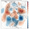
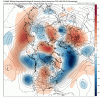
Seeing a cascade of cyclonic wave breaking in the North Atlantic storm track coupled w/ a parade of 50-50 lows & having the tropospheric polar vortex in your backyard over Northern Canada is making the weenie side of me very happy in the longer term.

If you want a beefy -NAO & threats for coastal cyclones, this how you get them

View attachment 27705
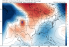
That big vortex sitting over Atlantic Canada is exactly what you want to see around here to score a big time Miller B winter storm. The only thing separating this weeks setup from glory and/or a devastating ice storm with a high that “locks in” is that feature right there. The fact that it’s showing up on the ensembles too and given that we have the primary lobe of the tropospheric polar vortex sitting in northern Canada, waiting to phase with a s/w in the polar jet, I wouldn’t be surprised to see a big trough show up there in the extended.

I like what I am reading from Webber. Sounds like the positives outweighs the negatives at this point for winter storms to develop down the road. Just have to wait to let all the factors play out to give us a good shot.
 
So far this “winter” is already doing better outside CAD areas of NC, sure no snow in southern MS/AL/GA/SC or even NC but some areas that whiffed last year are finally seeing something
“ even NC” doesn’t almost the entire state of NC outside of the mountains not average its first accumulating snowfall till January ?

Im just saying snow is obviously not an expectation this time of year even in NC.
 
The energy is actually there with that storm but the northeast confluence that caused it to be a CAD storm before cutting up (even on that laughable 12z) is even faster this run.

Just ridiculous that you can have changes that fast. Maybe we'll get an eastern trough sometime in January so we don't have to rely on crazy blocking.

Edit: Loooool, we've gone from an ice storm to possible severe weather in two runs. My confused cat meme is true in this one, except it took two runs.
 
The energy is actually there with that storm but the northeast confluence that caused it to be a CAD storm before cutting up (even on that laughable 12z) is even faster this run.

Just ridiculous that you can have changes that fast. Maybe we'll get an eastern trough sometime in January so we don't have to rely on crazy blocking.

Edit: Loooool, we've gone from an ice storm to severe weather in two runs. My confused cat meme is true in this one.
I DONT HAVE ACCESS TO THE MAPS IS THE SEVERE WEATHER FOR CENTRAL ALABAMA OR FURTHER E/NE
 
The GEFS were being .. well the GEFS tonight .. lots of activity beginning with next weeks storm... whatever happens with that thing it’s looking more likely it’s going to be a high impact event across a lot of the US
 
Trend seems to be Cool but not cold so far this year. Looking at this first map below you would think we would have a pretty nice tap of cold air in later December
gfs_mslpa_nhem_38.png
Although the 2M temps look a bit better the upper levels really aren't showing much in the way of anamolous cold.
gfs_T850a_nhem_38.png

Makes you wonder if that lack of Artic sea ice that you hear so much about will make even good patterns more moderated now.
 
Trend seems to be Cool but not cold so far this year. Looking at this first map below you would think we would have a pretty nice tap of cold air in later December
View attachment 27762
Although the 2M temps look a bit better the upper levels really aren't showing much in the way of anamolous cold.
View attachment 27763

Makes you wonder if that lack of Artic sea ice that you hear so much about will make even good patterns more moderated now.
I’m almost certain sea ice has nothing to do with upper level cold?? I’m sure by end of January you’ll feel some real cold ?
 
6z gfs, our winter storm is back. 1051 H diving down end of run.
 
gotta like what the GEFS is showing, not a bad pattern for a miller B, can notice some type of trough in the plains and that cold vortex in NE Canada, also this time with blocking which would keep a 50/50 hanging out longer which would allow some sort of parent high to stay much longer, just gotta get a stronger high 1576070769865.png1576070798289.png
 

Attachments

  • gfs-ens_z500a_nhem_fh180_trend.gif
    gfs-ens_z500a_nhem_fh180_trend.gif
    1.2 MB · Views: 27
ALDOT has Been treating the roads this am . Wrecks everywhere
e92d0f8b4ab572e5a947aabe56aa041b.jpg


Sent from my iPhone using Tapatalk
 
I'm really liking where the ensembles seem to want to go next week and beyond. -AO comes back, -NAO returns. It doesn't look amazingly cold but cool (pacific still needs work). Not looking at individual storms but I love the return of blocking up top and nice big 50/50 lows to push the storm track south. Perhaps through January and February this will translate in to a production pattern for us. At the very least we feel "wintery" through the end of the year.

1576072604510.png
 
Fwiw, the GEFS certainly seems to be on board with the idea of a CAD event sometime around the solstice over the Carolinas.
View attachment 27764

It seems like that crazy GFS storm that keeps showing up in a couple weeks has a decent signal on the ensembles. I bet that's where the increase in the mean shows up. Maybe a timeframe to watch.
 

Attachments

  • 1576073605081.png
    1576073605081.png
    433.6 KB · Views: 37
  • 1576073640546.png
    1576073640546.png
    275.5 KB · Views: 38
  • 1576073669120.png
    1576073669120.png
    301.6 KB · Views: 35
Yeah, that storm system that some keep talking about on the GFS around the 20th/21st does have my attention as well, but it's too far out to speculate on anything for my liking. Should be able to get a better understanding of what could turn out as we head into the weekend, since by then it would be in the 6-7 day window.

Sent from my SM-A102U using Tapatalk
 
Last edited:
Not seeing the 21st storm. No strong blocking. 50/50 low heading out. No strong high pressure. No really cold anomalies nearby. No Euro support. Looks like a crappier version of the coming storm, TBH. Doesn't mean things couldn't change, but the stars will probably have to line up just right, and the window is narrow.

The good news is, there really isn't a hint of a terrible pattern setting up in a stable way. And it wouldn't take much to transform this seasonal pattern (which is better than what we've seen in recent years) into a favorable winter pattern.
 
Back
Top