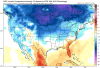
Need the ULL to shield parts of NC before we get anything. Not out of the realm of possibility this far out.ICON looks so good for track, so close to snow in NC with sfc temps in the 30s and 850s near freezing
-
Hello, please take a minute to check out our awesome content, contributed by the wonderful members of our community. We hope you'll add your own thoughts and opinions by making a free account!
You are using an out of date browser. It may not display this or other websites correctly.
You should upgrade or use an alternative browser.
You should upgrade or use an alternative browser.
Pattern The Great December Dump
- Thread starter Rain Cold
- Start date
Blue_Ridge_Escarpment
Member
Icon is horrible with surface temps. Even so, it was 34 in WNC, so very close even verbatim.I’m honestly surprised the icon wasn’t colder. The High wasn’t In a bad position I didn’t think.
Sent from my iPhone using Tapatalk
NBAcentel
Member
Big vortex in the NE more south so far this run (gfs)
The energy seems much weaker this run. While a bit, south at the same latitude.
Edit: Probably not going to be another NS piece this run
Edit: Probably not going to be another NS piece this run
Right now, the GFS seems to be too weak, differences from the 00z NAM


Yes it’s the NAM, but pretty good agreement with the EURO so here is the HR84 maps. Not a bad look. Can we line up all the players on the field?.


Pathetic..1042 gone like a fart in the wind. No one knows the recipe for snow. We can pretend, but we don’t
Webberweather53
Meteorologist
Any particular reason why people are choosing to look at & get upset over 384 hr operational model runs?
accu35
Member
Good gracious at the Euro along the gulf coast. Hours and hours of rain. To bad this isn't cold enough
Webberweather53
Meteorologist
Good gracious at the Euro along the gulf coast. Hours and hours of rain. To bad this isn't cold enough
Like the GFS, this Euro run is simply way too slow with our shortwave, we need it to be about a day faster to have a chance to cash in. By the time overrunning precipitation attempts to reinforce the CAD dome, it's too little too late. Again, contrary to popular misconception here, it's not that we don't have the cold here first, it's the opposite problem in that the cold air is leaving before we start getting any appreciable moisture involved.
Our wave needs to emerge from the southern Rockies by about the time this vortex east of New England gets to the longitude of Newfoundland, it's too slow in this case. Northern stream interaction, a weaker wave, and a slower Atlantic Canada trough are ways to improve the timing.

Not having the cold in place first is equivalent to the cold hauling out too soon or the storm coming in too late or whatever you want to call it. We have cold in place many times throughout the winter. It's just gone most of the time before the precipitation moves in.Like the GFS, this Euro run is simply way too slow with our shortwave, we need it to be about a day faster to have a chance to cash in. By the time overrunning precipitation attempts to reinforce the CAD dome, it's too little too late. Again, contrary to popular misconception here, it's not that we don't have the cold here first, it's the opposite problem in that the cold air is leaving before we start getting any appreciable moisture involved.
Our wave needs to emerge from the southern Rockies by about the time this vortex east of New England gets to the longitude of Newfoundland, it's too slow in this case. Northern stream interaction, a weaker wave, and a slower Atlantic Canada trough are ways to improve the timing.
View attachment 28358
I can't speak for others, but what I mean by having cold first is that I'd like to see a cold pattern established...not a marginal, uber-transient cold shot that is in and out. I mean, a legitimate eastern US cold pattern. And then deal with precipitation. Some want to see the opposite--make it wet and then hopefully time a cold shot. I'm not sure which way is statistically better, but I'll take my chances with the cold pattern.
Most of our events do require good timing, I'll grant that. It seems like it's been so long since we've paired a good cold pattern with an active southern stream. Maybe the -NAO unicorn will help with that this year, finally.
Anyway, I agree that 384 maps shouldn't be taken seriously, but they're fun to look at. Most people probably know they are unlikely to verify...at least I hope.
Webberweather53
Meteorologist
We're trending towards another CAD event just in time for Christmas as our southern stream wave slows down even more in the models. This would certainly be a far cry from the "torch" most were expecting even a few days ago.

Since some people still can't access the site it's a perfect time to say that I think the first 7 to 10 days of Jan we fight a little SE ridge, then for the rest of January it's on like donkey Kong before we fight the SE again in Feb
Sent from my SM-G975U using Tapatalk
Sent from my SM-G975U using Tapatalk
Webberweather53
Meteorologist
The few EPS members that have any wintry precipitation in the Carolinas this weekend have a faster arrival of precip & confine it near/west of I-85 (GSO-CLT) and to the mtns. We'll need to see this upper low come a bit further north/faster to have any chance here but it looks like there may be enough cold air to work w/ in at least the mountains & NW piedmont of NC for wintry weather if we can get the timing right.
The 50-50 low is still trending southward & dragging its feet in subsequent EPS runs which is keeping our CAD high around longer in recent suites. Regardless of snow/ice, it certainly will be chilly this weekend.

The 50-50 low is still trending southward & dragging its feet in subsequent EPS runs which is keeping our CAD high around longer in recent suites. Regardless of snow/ice, it certainly will be chilly this weekend.
Webberweather53
Meteorologist
The agreement between the European & CFS weeklies on the return of the -EPO/+TNH in early January is actually quite remarkable. It's amazing what happens when the +IOD finally calms down & the tropical West Pac has a chance to re-establish itself. The coldest air in the NH will be getting transported towards our side of the pond to start the month, there may be some SE ridge resistance at first.

.png")
Webberweather53
Meteorologist
The agreement between the European & CFS weeklies on the return of the -EPO/+TNH in early January is actually quite remarkable. It's amazing what happens when the +IOD finally calms down & the tropical West Pac has a chance to re-establish itself. The coldest air in the NH will be getting transported towards our side of the pond to start the month, there may be some SE ridge resistance at first.
View attachment 28367
View attachment 28368
The West Pac's fingerprints are empirically evident in producing this pattern.
Compare Jan-Feb 2013-19's OLR anomalies to the CFSv2 forecast.


The resulting 500mb pattern as you all know looks something like this:
I'd anticipate the 500mb pattern to grow more amplified on the models as verification approaches w/ the Alaskan ridge gaining latitude while the tropospheric polar vortex lobe over northern Canada slides southward in later outlooks.

accu35
Member
Lol, Webb you on top of things this morning.The West Pac's fingerprints are empirically evident in producing this pattern.
Compare Jan-Feb 2013-19's OLR anomalies to the CFSv2 forecast.
View attachment 28370
View attachment 28371
The resulting 500mb pattern as you all know looks something like this:
View attachment 28372
Southernsnow
Member
I can only access the site through my telephone. I am still getting an error message through Google chrome and internet explorer.
Webberweather53
Meteorologist
The West Pac's fingerprints are empirically evident in producing this pattern.
Compare Jan-Feb 2013-19's OLR anomalies to the CFSv2 forecast.
View attachment 28370
View attachment 28371
The resulting 500mb pattern as you all know looks something like this:
I'd anticipate the 500mb pattern to grow more amplified on the models as verification approaches w/ the Alaskan ridge gaining latitude while the tropospheric polar vortex lobe over northern Canada slides southward in later outlooks.
View attachment 28372
Here's the resulting temperature pattern.
We're probably gonna have to fight the SE US ridge, but this pattern by seeding the continent w/ Siberian air & trapping the tropospheric polar vortex over Canada, has the potential to give us the coldest air masses we can handle when the SE US ridge does occasionally break down. Coupled with the active subtropical jet we have this winter, I'm fairly upbeat about our chances for snow & ice going forward in January & February
View attachment 28373
What do you think is going to differentiate last years -EPO/+TNH torch fest versus 14/15 colder option? We hoping for some form of Npac low and scandi. ridge


NoSnowATL
Member
What do you think is going to differentiate last years -EPO/+TNH torch fest versus 14/15 colder option? We hoping for some form of Npac low and scandi. ridge
View attachment 28375
View attachment 28374
Question, last year would have been cold if we didn’t lose to the SER correct? And looks like we will be rolling the dice again? Trying to make sure I’m reading you and Webb right.
Sent from my iPhone using Tapatalk
accu35
Member

Webberweather53
Meteorologist
What do you think is going to differentiate last years -EPO/+TNH torch fest versus 14/15 colder option? We hoping for some form of Npac low and scandi. ridge
View attachment 28375
View attachment 28374
What do years like 2014 & 15 do differently than last year & 2018 that also +TNHs but were warmer?
The colder +TNH years in the SE US both recently & since the beginning of the satellite era have more persistent & stronger convective forcing just west of the International Dateline ~160 degrees east. Basically this tropical forcing pattern w/ enhanced convection just west of the dateline that's creating the +TNH/-EPO to begin with is more intense in years where we are colder in the SE US. The raw OLR anomalies & difference composite basically resembles modoki/central Pacific El Nino just shifted slightly westward.


So, how is this year performing thus far?
We have more persistent & intense convection just west of the dateline like in the colder composite. This is very encouraging to see.

Webberweather53
Meteorologist
What do years like 2014 & 15 do differently than last year & 2018 that also +TNHs but were warmer?
The colder +TNH years in the SE US both recently & since the beginning of the satellite era have more persistent & stronger convective forcing just west of the International Dateline ~160 degrees east. Basically this tropical forcing pattern w/ enhanced convection just west of the dateline that's creating the +TNH/-EPO to begin with is more intense in years where we are colder in the SE US. The raw OLR anomalies & difference composite basically resembles modoki/central Pacific El Nino just shifted slightly westward.
View attachment 28376
View attachment 28377
So, how is this year performing thus far?
We have more persistent & intense convection just west of the dateline like in the colder composite. This is very encouraging to see.
View attachment 28378
We also have had more convection just west of the dateline than even 2014 & 15 up to this point in the season, another really positive sign going forward.

Webberweather53
Meteorologist
We also have had more convection just west of the dateline than even 2014 & 15 up to this point in the season, another really positive sign going forward.
View attachment 28379
It would also make sense that extra convection just west of the dateline would be favorable for more cold down here in the SE US, this extra convective forcing will supply the subtropical/southern branch of the jet with excess westerly momentum & moisture, encouraging more frequent breakdown of the SE US ridge & of course winter storms in the southern US.
Wouldn’t sleep on the 21/22 system yet ... gefs still has a good few with a more robust system tracking more northwest ... seems too odd everyone agrees on a really southern location still this far out... would think we see a shift more north in the coming days
Webberweather53
Meteorologist
Wouldn’t sleep on the 21/22 system yet ... gefs still has a good few with a more robust system tracking more northwest ... seems too odd everyone agrees on a really southern location still this far out... would think we see a shift more north in the coming days
Yes, the solstice storm has still yet to disappear from the GEFS. A last second NW adjustment & earlier precip onset could result in snow/ice in the NW & far western piedmont of NC + the mountains.
.png")
Webberweather53
Meteorologist
Oh boy. A legit -EPO/-NAO coupled w/ an active subtropical jet to start a new year & decade.
Sign me up.

Sign me up.
accu35
Member
I love your off days of work, lol.Oh boy. A legit -EPO/-NAO coupled w/ an active subtropical jet to start a new year & decade.
Sign me up.
View attachment 28381
Webberweather53
Meteorologist
I love your off days of work, lol.
We're also probably gonna be staring down the barrel of RMM MJO phase 7 in early January which is notorious for producing winter storms in NC.
I'm very curious to see where we stand in a week or so.

B
Brick Tamland
Guest
Oh boy. A legit -EPO/-NAO coupled w/ an active subtropical jet to start a new year & decade.
Sign me up.
View attachment 28381

I know there is more to this....BUT look how much Difference there is in this vs last December (and winter) What a nice change to see that its not deep into phases 3, 4, 5 and 6.We're also probably gonna be staring down the barrel of RMM MJO phase 7 in early January which is notorious for producing winter storms in NC.
I'm very curious to see where we stand in a week or so.
View attachment 28382
Good gracious at the Euro along the gulf coast. Hours and hours of rain. To bad this isn't cold enough
I know right! If it was going to be cold enough, it would have been a lot of snow.
Good grief, always the LR..
Of course it always is the long range, but watch for consistency with future runs!
Wouldn’t sleep on the 21/22 system yet ... gefs still has a good few with a more robust system tracking more northwest ... seems too odd everyone agrees on a really southern location still this far out... would think we see a shift more north in the coming days
I now think that there won't be much in the way of frozen precip with that 21st/22nd system. There could be a brief window for frozen precip mostly over western NC. The cold air is lacking and a ridge messes everything up. If that ridge wasn't in the way, colder air may have been at play.
SnowNiner
Member
Oh boy. A legit -EPO/-NAO coupled w/ an active subtropical jet to start a new year & decade.
Sign me up.
View attachment 28381
Yeah, the pacific down the line starts to look much better. But verbatim, doesn't look very cold in the SE. Perhaps if the ridge were taller or we got a 50/50 low would help. Hopefully in a few weeks time we can start to get the arctic into the SE. Right now this still reminds me alot of last year (cold stuck in the west/midwest). But you guys are all over the tropical intricacies of how this year is different so I'll go with that. But until it's in mid range modeling, I weenie worry.
")
Attachments
Webberweather53
Meteorologist
Yeah, the pacific down the line starts to look much better. But verbatim, doesn't look very cold. Perhaps if the ridge were taller or we got a 50/50 low would help. Hopefully in a weeks time we can start to get the arctic into the SE. Right now this still reminds me alot of last year (cold stuck in the west/midwest). But you guys are all over the tropical intricacies of how this year is different so I'll go with that. But until it's in mid range modeling, I weenie worry.
As I noted in an earlier post, there may be some resistance from the SE ridge at first at the tail end of Dec or so, however I do eventually think we'll turn cold & perhaps very cold at that. Prior experience and the composite pattern in cases like this both suggest that long range NWP models are probably dampening the wave pattern over North America too much & I'd expect the big vortex over northern Canada to slide closer to the lower 48 as we approach verification in this case.
NBAcentel
Member
Difference vs last year was a terrible MJO, no blocking/low heights around Greenland/+NAO, we basically have had to rely on a pattern that has a -EPO along with a active STJ and some sort of 50/50 low or SE Canada vortex these past years for our winter storms which have been close because with those setups it’s all bout timing, it’s nice to see some blocking with a -EPO, Pacific and Atlantic cooperating for once
But man that look last year was ugly, GOA ridge with a western US trough and a ridge in the SE, that was ugly
But man that look last year was ugly, GOA ridge with a western US trough and a ridge in the SE, that was ugly
Maybe we get some resistance from the SER but honestly the past few months we’ve seen how the SER has lasted .. it’s barely been able to have staying power and if it hits it’s not that hot at all .. more like a seasonable ridge at best ... don’t think we’re going to see a huge problem with the SER this winter .. we just gotta hit timingAs I noted in an earlier post, there may be some resistance from the SE ridge at first at the tail end of Dec or so, however I do eventually think we'll turn cold & perhaps very cold at that. Prior experience and the composite pattern in cases like this both suggest that long range NWP models are probably dampening the wave pattern over North America too much & I'd expect the big vortex over northern Canada to slide closer to the lower 48 as we approach verification in this case.
I think its happening man. I could fall flat on my face but is really difficult to not go all in on JanuaryWe're also probably gonna be staring down the barrel of RMM MJO phase 7 in early January which is notorious for producing winter storms in NC.
I'm very curious to see where we stand in a week or so.
View attachment 28382
Sent from my SM-G975U using Tapatalk
Glad we’re back up and running. Papa’s got
A brand new bag!
A brand new bag!
Also, this weekends system I noticed that the euro is still cooling 850's every run. I compared to yesterdays 12z run and they were cooler this run over parts of the SE. I still think it could be a dud, BUT we shall see.