Webberweather53
Meteorologist
Wash. Rinse. Repeat.

Yeah it’s a pretty progressive pattern shaping up....
Yes.So we will have a milder air pattern across the SE until at least mid December?
Sent from my SM-G950U using Tapatalk
That is as ugly as it gets. And almost on the exact date it showed up last year and winter was over. That pattern takes a very long time to get out of and we won't have the luxury of an early season snow this year before it sets in.Nope, this monstrous Gulf of Alaska trough in the extended as we experience +EAMT this week will flood the North American continent w/ mild Pacific air & most of the cold air will remained bottled up in extreme northern Canada or exit stage right over the Atlantic Ocean. I hope u like stale, Pacific air.
View attachment 26633
Nope, this monstrous Gulf of Alaska trough in the extended as we experience +EAMT this week will flood the North American continent w/ mild Pacific air & most of the cold air will remained bottled up in extreme northern Canada or exit stage right over the Atlantic Ocean. I hope u like stale, Pacific air.
View attachment 26633


It does look rather seasonable which is ok. But that EPS modeled pattern gives me nightmares about last winter. Isn't that the same pattern that wrecked the 11-12 winter too?Warmest 5 day block on the 6z GEFS though 264. Rather be chasing 10+ day warm-ups than 10+ day cool-down, I guess.
View attachment 26638
yeah..oopsWarmest 5 day block on the 6z GEFS though 264. Rather be chasing 10+ day warm-ups than 10+ day cool-down, I guess.
View attachment 26638

Not 100% sure on that one. The other thing I'd keep in mind is that these anomaly maps can be confusing in that they often provide an illusion, especially up in Canada, that there's a torch going on. A five day AN block in Canada doesn't mean it still isn't cold, depending on the degree of the anomaly.It does look rather seasonable which is ok. But that EPS modeled pattern gives me nightmares about last winter. Isn't that the same pattern that wrecked the 11-12 winter too?
Still hoping this is a necessary evil as it matches up with past good nino's. Of course I am cherry picking the good ones.
View attachment 26636View attachment 26637


Some of those years in your composite had a decent -AO in December which isn't going to happen this year. +AO/+NP Decembers are downright hideous.
View attachment 26640
View attachment 26641
At least they get better in February (shocker).
View attachment 26642


Fat chance

I bet winter will be mild and then followed by a cold spring.
I bet winter will be mild and then followed by a cold spring.
Or you could have a cold winter and not get any snow at all. When it comes to the south, I'm not even sure it matters whether its a warm or cold winter. Does having a cold winter significantly increase the chances for snow in the deep south ? I'm not so sure.You can have a mild winter temperature wise. And still get a couple good snow storms. It’s all about timing
Sent from my iPhone using Tapatalk
Webb, can you find us anything that could change this outcome? I get this sick feeling that you have given up on winter.Some of those years in your composite had a decent -AO in December which isn't going to happen this year. +AO/+NP Decembers are downright hideous.
View attachment 26640
View attachment 26641
At least they get better in February (shocker).
View attachment 26642
No, having a colder than normal winter doesn't necessarily mean that there would be more snow in the southeast. There could be cold blasts after cold blasts and still not end up with nothing, but maybe some flurries. Even if it's a warm winter overall, places in the southeast can still experience snowfall. The lower latitudes can experience all types of extreme weather in a short period of time during the winter. I've seen places in the southeast get accumulating snow after a tornado outbreak. So yeah, I don't think it really matters.Or you could have a cold winter and not get any snow at all. When it comes to the south, I'm not even sure it matters whether its a warm or cold winter. Does having a cold winter significantly increase the chances for snow in the deep south ? I'm not so sure.
It's really a matter of timing. a good example of this is 1927, which I believe was NC's warmest or one of the warmest on record. Yet we still got a record-breaking snowstorm in early March. Truly anything can happen. Colder winters just increase the chance of a shortwave meeting up with colder air.No, having a colder than normal winter doesn't necessarily mean that there would be more snow in the southeast. There could be cold blasts after cold blasts and still not end up with nothing, but maybe some flurries. Even if it's a warm winter overall, places in the southeast can still experience snowfall. The lower latitudes can experience all types of extreme weather in a short period of time during the winter. I've seen places in the southeast get accumulating snow after a tornado outbreak. So yeah, I don't think it really matters.
Sent from my SM-A102U using Tapatalk
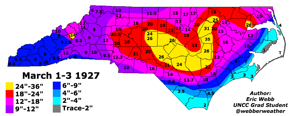

That’s a beauty. Hard to even fathom, honestlyIt's really a matter of timing. a good example of this is 1927, which I believe was NC's warmest or one of the warmest on record. Yet we still got a record-breaking snowstorm in early March. Truly anything can happen. Colder winters just increase the chance of a shortwave meeting up with colder air.
Graphic courtesy of Webb's site
It's really a matter of timing. a good example of this is 1927, which I believe was NC's warmest or one of the warmest on record. Yet we still got a record-breaking snowstorm in early March. Truly anything can happen. Colder winters just increase the chance of a shortwave meeting up with colder air.
Graphic courtesy of Webb's site
That’s a beauty. Hard to even fathom, honestly


I would be willing to bet that the March 1927 snow in NC happened mostly at night, early in the morning, or late in the afternoon. Hard to get that much snow during the middle of the day in March in NC due to the sun angle.
According to the tales by my grandfather (may he rest in peace) it did fall at night. They had no idea it was coming until they awoke to see all the snow that had fallen overnight.I would be willing to bet that the March 1927 snow in NC happened mostly at night, early in the morning, or late in the afternoon. Hard to get that much snow during the middle of the day in March in NC due to the sun angle.
Rain/snow in my forecast.CMC is not backing down, rain/snow mix far south as far northern Alabama and Northern Georgia. I wouldn't be surprised to see some flakes mixing in with the patchy light rain across northern Atlanta suburbs Monday AM.
Sent from my SM-A102U using Tapatalk
BAMWX
@bamwxcom
Also for the record I do not care what these models are showing DEC 15th+ we still believe they are simply incorrect. #natgas #energy #AGwx Bamwx.com
Not so fast!Nope, this monstrous Gulf of Alaska trough in the extended as we experience +EAMT this week will flood the North American continent w/ mild Pacific air & most of the cold air will remained bottled up in extreme northern Canada or exit stage right over the Atlantic Ocean. I hope u like stale, Pacific air.
View attachment 26633
 ! BAM says the models are wrong! I would agree if they were showing cold!?
This is interesting got the entire nhem?So which run is right ?
Afternoon ensembles :
There are some eps members with snow down your way on the 4th and 12thNot so fast!! BAM says the models are wrong! I would agree if they were showing cold!

If i recall the 93 blizzard started on a Friday evening in GA. It got going good overnight.Sun angle means nothing when you’re talking about a blizzard. 93 started around 10am.
Sent from my iPhone using Tapatalk
That look N.C.highcountry posted, is tent worthy! Really a good look, I wish it would set up just for a week or two!There are some eps members with snow down your way on the 4th and 12th
Sent from my SM-G975U using Tapatalk
?You all can decipher what time the precip started with this gif https://twitter.com/i/status/1093544439321116673If i recall the 93 blizzard started on a Friday evening in GA. It got going good overnight.
If i recall the 93 blizzard started on a Friday evening in GA. It got going good overnight.


 ! BAM says the models are wrong! I would agree if they were showing cold!