I’m ok with a normal to above normal first half of December if we flip the switch toward the latter half of December.
-
Hello, please take a minute to check out our awesome content, contributed by the wonderful members of our community. We hope you'll add your own thoughts and opinions by making a free account!
You are using an out of date browser. It may not display this or other websites correctly.
You should upgrade or use an alternative browser.
You should upgrade or use an alternative browser.
Pattern The Great December Dump
- Thread starter Rain Cold
- Start date
Euro onboard with a Clipper on the 6th


cd2play
Member
It would be sad if we don't even have another freeze by ChristmasIt's possible we don't see another freeze into mid Dec. The upcoming cold spell first of the month now only has 33 as the lowest temp, according to NWS anyway. Probably see one, but may be just one night. Nov is going to end up around -3 BN, so nothing spectacular.
RollTide18
Member
“Golden” years... Huntsville, AL’s snowfall average has been virtually cut in half from nearly 4” from 1950-1985 to about 2” from 1986 to present. It’s all a matter of perception and I’d hardly call the more modern era “Golden”.
The 2010s have been "Golden" for the Southern and Central part of Alabama.
Me too. But the problem is, does it actually switch? It seems like the typical theme this decade is the December pattern repeats. The cold winters on 09-10 and 10-11 were cold Decembers. I know December 13 was a torch and the winter turned out good. So there are exceptions but if December torches I'd expect much of the same all winter with a few cold shots and storm chances sprinkled in.I’m ok with a normal to above normal first half of December if we flip the switch toward the latter half of December.
Webberweather53
Meteorologist
The only part of Alabama that’s seen well above (>150%) normal snowfall in the 2010s even against the 1981-2010 average that’s already a significant downward step change from much longer term means, is southern Alabama near the Gulf coast where storms are so infrequent that only a couple random events in a decade automatically push these areas to well above normal levelsThe 2010s have been "Golden" for the Southern and Central part of Alabama.
The latter point is pretty easy to understand if you acknowledge man made climate change is real and is significantly moving the base state in a milder direction. You don’t get 9 warm Decembers in a row by random chance
Yeah, if we assumed no global warming since the 1981-2010 average, the stat chance for 9 Decembers in a row being exactly at or warmer than normal is a mere ~1 in 500. And many of these have been very warm. So, the random chance of the consistency and degree of warmth is actually way less than 1 in 500.....probably something like 1 in several thousand. So, indeed, we know it has to be due to a warmer base state vs the 1981-2010 average.
Most don't care about the north, including me because they always get their fair share. But how are cities like Chicago, Minneapolis and New York this decade compared to long longterm averages? You'd think those areas actually benefit from a warmer climate since warmer air holds more moisture and it's still cold enough to snow there anyway.The only part of Alabama that’s seen well above (>150%) normal snowfall in the 2010s even against the 1981-2010 average that’s already a significant downward step change from much longer term means, is southern Alabama near the Gulf coast where storms are so infrequent that only a couple random events in a decade automatically push these areas to well above normal levels
So how has the warming increased DC’s NY, and BOS annual totals? It seems they get 12-24”+ snows at the drop of a hat!? Maybe it’s always been like that??
I don't think DC gets very many big storms. Every now and then they'll get dumped on, but DC has a pretty bad climo for snow.So how has the warming increased DC’s NY, and BOS annual totals? It seems they get 12-24”+ snows at the drop of a hat!? Maybe it’s always been like that??
NoSnowATL
Member
I don't think DC gets very many big storms. Every now and then they'll get dumped on, but DC has a pretty bad climo for snow.
Yea 15.4 in per year sucks. I would hate that avg.
Sent from my iPhone using Tapatalk
I’ve always thought the DC Snow Hole was a myth. It seems like they get multiple 15-20 inch events in a decade. Just look at February 2010 and January 2016, most of us would LOVE to have that much snow in a single winter.
I mean compared to ATL that's a lot, but really 15" is nothing compared to a lot of cities.Yea 15.4 in per year sucks. I would hate that avg.
Sent from my iPhone using Tapatalk
DC gets some years where they get hammered and other years where they get hardly nothing. It's feast or famine there. Reagan National had 17" last winter, but only 8" in 2017-18 and only 3" in 2016-17.I’ve always thought the DC Snow Hole was a myth. It seems like they get multiple 15-20 inch events in a decade. Just look at February 2010 and January 2016, most of us would LOVE to have that much snow in a single winter.
pcbjr
Member
Folks ... It's Thanksgiving ... be happy for what you have rather than fretting about what you may not someday ...
MichaelJ
Member
The latter point is pretty easy to understand if you acknowledge man made climate change is real and is significantly moving the base state in a milder direction. You don’t get 9 warm Decembers in a row by random chance
Not to be a contrarian here, but in GSO records, there were 10 Decembers in a row AN from 1920 thru 1929. Also there were 10 Februarys in a row AN from 1948 thru 1957. The most I could find for January was 8 in a row from 1927 thru 1934
“Golden” years... Huntsville, AL’s snowfall average has been virtually cut in half from nearly 4” from 1950-1985 to about 2” from 1986 to present. It’s all a matter of perception and I’d hardly call the more modern era “Golden”.
Here we have had more snow in the past ten years then the past twenty which includes '93. Besides '93, I can remember two snows over 2" until 2008. While it missed my house personally, the ULL dropped 4-6" across Central AL in 2008. The storm in February 2010 dropped 3-4". The Christmas snow of 2009 dropped 3-4" followed by 2-3" two weeks later. The Snowjam dropped 3-4" with temps in the teens and of course the big one in 2017 dropped 9-10" here. And to count it we had 1.5 to 2" in January of 2018.
Snows over ten inches occured in central or north AL in 2011, 2014, 2015 and 2017. Which is pretty much one every two years. So yes, the past ten years have been golden for AL snows.
Webberweather53
Meteorologist
Here we have had more snow in the past ten years then the past twenty which includes '93. Besides '93, I can remember two snows over 2" until 2008. While it missed my house personally, the ULL dropped 4-6" across Central AL in 2008. The storm in February 2010 dropped 3-4". The Christmas snow of 2009 dropped 3-4" followed by 2-3" two weeks later. The Snowjam dropped 3-4" with temps in the teens and of course the big one in 2017 dropped 9-10" here. And to count it we had 1.5 to 2" in January of 2018.
Snows over ten inches occured in central or north AL in 2011, 2014, 2015 and 2017. Which is pretty much one every two years. So yes, the past ten years have been golden for AL snows.
The winters in the mid 20th century were much snowier. Even against the 1981-2010 average the snowfall departures from average are ~100-125% of normal at best in northern Alabama, slightly above this average which is already significantly lower than the long term means if you include years from the mid 20th century, so these are basically normal to even slightly below normal winters snowfall wise against those truly “golden” years. Anecdotally, this seems like a lot of snow to you esp compared to the 1990s, but the harsh reality is it really isn’t.
The only part of Alabama that’s seen well above (>150%) normal snowfall in the 2010s even against the 1981-2010 average that’s already a significant downward step change from much longer term means, is southern Alabama near the Gulf coast where storms are so infrequent that only a couple random events in a decade automatically push these areas to well above normal levels
I don't think that is correct. I think my average in East Central AL is around 2". If that is the case I received 3-4" in 2009-2010, 6-7" in 2010-2011, 3-4" in 2013-2014 and 11" in 2017-2018.
Webberweather53
Meteorologist
The long term average including these pre 1990s winters at Huntsville is a little over 3”, the average of the 2010s is 3.4”, virtually normal.The winters in the mid 20th century were much snowier. Even against the 1981-2010 average the snowfall departures from average are ~100-125% of normal at best in northern Alabama, slightly above this average which is already significantly lower than the long term means if you include years from the mid 20th century, so these are basically normal to even slightly below normal winters snowfall wise against those truly “golden” years. Anecdotally, this seems like a lot of snow to you esp compared to the 1990s, but the harsh reality is it really isn’t.
Webberweather53
Meteorologist
I don't think that is correct. I think my average in East Central AL is around 2". If that is the case I received 3-4" in 2009-2010, 6-7" in 2010-2011, 3-4" in 2013-2014 and 11" in 2017-2018.

I'm sure many of us would gladly take 3" in the winter. But yeah climatology is different for them. Snow is pretty much guaranteed if you live north of NC while for us it is special.DC gets some years where they get hammered and other years where they get hardly nothing. It's feast or famine there. Reagan National had 17" last winter, but only 8" in 2017-18 and only 3" in 2016-17.
How did you make this chart?
No way that is correct, the 2017 snow alone would have put it a least close to normal. It shows my area around 50%. No way this area averages over 20" of snow a decade.
18z never disappoints! Giddy up!?

Webberweather53
Meteorologist
This is a map from the midwestern regional climate center and checking the official reporting stations nearby it’s not that far off from what I can tell.No way that is correct, the 2017 snow alone would have put it a least close to normal.
Stop! Hammertime 
I'm skeptical also. The area that was the most below normal for snowfall was the area that got hit hardest in the Dec 2017 snowstorm right ? Didn't some areas get close to a foot ?No way that is correct, the 2017 snow alone would have put it a least close to normal.
NoSnowATL
Member
I'm skeptical also. The area that was the most below normal for snowfall was the area that got hit hardest in the Dec 2017 snowstorm right ? Didn't some areas get close to a foot ?

Sent from my iPhone using Tapatalk
Looks like your area got 1-3" if this map is correct.
Sent from my iPhone using Tapatalk
NoSnowATL
Member
Looks like your area got 1-3" if this map is correct.
I live East of the 1inch number in southeast Gwinnett. I got a trace.
Sent from my iPhone using Tapatalk
Webberweather53
Meteorologist
The big caveat being for stations that actually reliably report snowfall, it’s slim pickings at some points in the last decade, very frustrating really.This is a map from the midwestern regional climate center and checking the official reporting stations nearby it’s not that far off from what I can tell.
This is your year. I can feel itI live East of the 1inch number in southeast Gwinnett. I got a trace.
Sent from my iPhone using Tapatalk

NoSnowATL
Member
This is your year. I can feel it
Well thank you for that. My kids would love to see snow falling from the sky for the 1st time. I hope we ALL see some!
Sent from my iPhone using Tapatalk
This is a map from the midwestern regional climate center and checking the official reporting stations nearby it’s not that far off from what I can tell.
Yeah something is bad wrong by my calculations in Cleburne county where the 25-50% is centered received at least 25” since January 2010 and I may have forgotten a event or two.
Jessy89
Member

Maybe some ice for some?
Sent from my iPhone using Tapatalk
Sent from my iPhone using Tapatalk
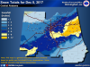
Here is BMX’s map.
Attachments
Webberweather53
Meteorologist
Yeah there’s hardly any official reporting stations down there that have actually reported snow the entire decadeYeah something is bad wrong by my calculations in Cleburne county where the 25-50% is centered received at least 25” since January 2010 and I may have forgotten a event or two.
I came on here to see what might be ahead for December per today's models, just a quick check since you know been busy with family. Anyway low and behold Mack the only one who is on topic 
Sent from my SM-G950U using Tapatalk

Sent from my SM-G950U using Tapatalk
Yeah there’s hardly any official reporting stations down there that have actually reported snow the entire decade
Dang, that is pitiful, yet somehow unsurprising.