Warning here as well couplet moved 3 miles east of me right up 95Tornado warning for the storm to my SSW.
Sent from my SM-G950U using Tapatalk
Warning here as well couplet moved 3 miles east of me right up 95Tornado warning for the storm to my SSW.
The one near spring lake is going to be too damn close to meTornado warning for the storm to my SSW.

This cell is going to pass very close to me if it doesn’t weaken or get absorbed by the line behind. I’m essentially in the eastern-most purple area in SE Wake in your image.All the nope
Sent from my SM-G955U using Tapatalk
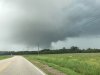
Its here and its no jokeThis cell is going to pass very close to me if it doesn’t weaken or get absorbed by the line behind. I’m essentially in the eastern-most purple area in SE Wake in your image.
It’s strenthening.Its here and its no joke
Sent from my SM-G955U using Tapatalk


The wind with the storm after the tornado warned cell was nuts heard a few trees pop. You are really going to get hit hard with that cell north of lillington@SD Hearing lots of thunder over your way.
I may be 2 miles too Far East. We’ll see in a sec.The wind with the storm after the tornado warned cell was nuts heard a few trees pop. You are really going to get hit hard with that cell north of lillington
Sent from my SM-G955U using Tapatalk