Z
Zander98al
Guest
The streaks in the qpf highlight the risk of supercells embedded or broken along a line or maybe ahead. 


.png")


I'll agree with this, if someone has an opposing well reasoned opinion than offer it, if this threat doesn't apply to your area or you have no analysis to provide then why come in here and troll it?Okay guys I like having the clown faces and all that stuff too. But continually just coming in here and spamming posts with them. Because you may not agree with something gets rather old. I'm putting my opinion out here on this setup. Yes probably isn't the most accurate always but doesn't mean it needs a clown or weinee for every post.
I'd like to throw out something as well with your comment. In the past 10 years my neighborhood has been hit by two ef3s in similar setups as this one higher shear low cape environments both l in late January Each event somebody was killed one down the street and another in a adjacent city. any tornado threat especially a ever changing winter setup requires all eyes.I can see where people's opinions can differ on severity of this system. But it only takes one hitting near you to make it a very bad day for you. So this is why I cover these storms like I do. Because they change on the drop of a pen sometimes; just how weather is. You can't be complacent on tornado risks.I'll agree with this, if someone has an opposing well reasoned opinion than offer it, if this threat doesn't apply to your area or you have no analysis to provide then why come in here and troll it?


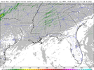
The updraft helicity swaths are there.One thing I'm noticing here is a lack of updraft helicity swaths. Perhaps the better dynamic support lifting out?View attachment 113677
.png")


Can anybody tell me why they cut off the tornado risk at northwest Georgia?Big tornado upgrade! I was on to something I guess ?
Farther south, greater low-level theta-e advection suggests that the
boundary layer will become at least neutral, and therefore greater
certainty of surface- or near-surface-based storms exists -- both
near the advancing cold front, and also with associated warm
advection-driven bands of convection in the free warm sector. As
noted above, very strong shear -- with south-southwesterly 850 mb
winds in excess of 50 to 60 kt increasing to west-southwesterly at
70 to 90 kt at mid levels -- is suggestive of supercells, and
attendant risk for damaging winds and several -- and possibly
locally strong/damaging -- tornadoes. As such, an upgrade to
enhanced risk is being introduced, centered across the Tennessee
Valley area from late afternoon through the evening hours.
View attachment 113687
There just having the winter is leaving blues Zander. , it spring is approaching , just mater time long range all models ensemblesOkay guys I like having the clown faces and all that stuff too. But continually just coming in here and spamming posts with them. Because you may not agree with something gets rather old. I'm putting my opinion out here on this setup. Yes probably isn't the most accurate always but doesn't mean it needs a clown or weinee for every post.
you the man Zander good call bud … u been staying with it manBig tornado upgrade! I was on to something I guess ?
Farther south, greater low-level theta-e advection suggests that the
boundary layer will become at least neutral, and therefore greater
certainty of surface- or near-surface-based storms exists -- both
near the advancing cold front, and also with associated warm
advection-driven bands of convection in the free warm sector. As
noted above, very strong shear -- with south-southwesterly 850 mb
winds in excess of 50 to 60 kt increasing to west-southwesterly at
70 to 90 kt at mid levels -- is suggestive of supercells, and
attendant risk for damaging winds and several -- and possibly
locally strong/damaging -- tornadoes. As such, an upgrade to
enhanced risk is being introduced, centered across the Tennessee
Valley area from late afternoon through the evening hours.
View attachment 113687
Probably going to have schools dismiss early tomorrow. The worst of the wind shouldnt get here until around the main time frame of the event I don't thinkThe wind is already picking up. Even if the main event so to speak doesn’t start to after 3pm, I wonder how schools will treat the wind threat. It appears that the wind will be high all day. The forecast discussion from HSV even mentioned a possible upgrade to high wind warning ? I wouldn’t think school systems would want buses running in 40-50 mph wind gusts before the storms even roll in. Just a thought.
What’s the TORCON index for today?
Brad Travis just showed wind gusts at 35+mph at 10am with it going higher as the day goes on. Pretty sure we will be without power because our power grid sucks in Arab. SighProbably going to have schools dismiss early tomorrow. The worst of the wind shouldnt get here until around the main time frame of the event I don't think
 12Z HRRR 10M wind gust starting at 8am
This guy knows his stuff. He called the tornadoes from earlier this month when no one was really speaking on it. I’m uneasy about this set up..
Sent from my iPhone using Tapatalk
 18Z HRRR running now but 12Z HRRR STP values really maximize east MS an west AL before fizzling lower to the east.
Still liking this, especially in MS where crossovers/timing looks the bestAll I’m saying is, this isn’t screaming a mega tornado outbreak or Super Tuesday outbreak or a big one in general like I have been seeing hyped, esp on Twitter. but more so your classic wintertime setup that brings 1 or so strong tornadoes which form along a boundary and several weaker ones

 18Z HRRR for comparison vs 12Z HRRR