accu35
Member
This looks little more bullish before fizzling?View attachment 11370018Z HRRR for comparison vs 12Z HRRR
This looks little more bullish before fizzling?View attachment 11370018Z HRRR for comparison vs 12Z HRRR
Parameters almost always go up getting closer to the event. I still feel like models are underestimating Thermodynamics as well.This looks little more bullish before fizzling?
Becoming more confident in a possible moderate at the state line.View attachment 11370018Z HRRR for comparison vs 12Z HRRR
My gut feeling tells me it's going to be a bit more isolated than the HRRR shows. A mix between the WRF- ARW and the HRRR.Legrunge mess View attachment 113699
I think it did go up slightly in MS and west AL with the same trend as 12Z.This looks little more bullish before fizzling?

I haven’t heard anything specifically but my district moved picture day that was scheduled for tomorrow. I’m guessing just in case but pictures are usually made first thing in the morningAnyone heard anything about schools and the NWS discussing early school closings tomorrow?
They usually start announcing later in the day. I imagine by 5 o'clock news. If I see any listings I'll post them here. If y'all see it y'all can post tooI haven’t heard anything specifically but my district moved picture day that was scheduled for tomorrow. I’m guessing just in case but pictures are usually made first thing in the morning
What I was saying probably could upgrade risk more. Very well could see a tornado outbreak across Alabama/Tennessee/Mississippi tommorow. Not as far fetched as previously thought.
Anyone heard anything about schools and the NWS discussing early school closings tomorrow?
I don't call every severe weather threat a tornado outbreak. And all I said was tornado outbreak seemed less far fetch. Your reading in to what I said too much. Also beg to differ we don't know yet how bad this event will be. I think it's still a plasuible idea for a little tornado outbreak. Also everything that I've said about y'all denying the boom potential with this event has came true. A lot of the folks in north Carolina that post in this thread are so sure about the weather textbook wise stuff but don't look at things logistical or possibility wise. Alabama weather follows a pattern like a lot of other places. I put my experience on weather events into my posts.The key is to not get carried away with calling every bout of severe weather a tornado outbreak. This set up looks like a few tornados could be likely with some of them being possibly stronger than average. Nothing more nothing less as of right now .. tornado outbreak does not seem likely at this point in time but the potential is there that a good storm or two can get cranking and produce a longer track strong tornado.
Nws is seemingly leaning towards the HRRR. I'd trust it. The event a week and half ago that had that tornado it predicted pretty well that setup as it got into 18 hours.I’ll tell you one thing, the HRRR is either gonna be a genius or fail tremendously. It is on a complete island regarding surface temps and low level lapse rates tomorrow.
What I was saying probably could upgrade risk more. Very well could see a tornado outbreak across Alabama/Tennessee/Mississippi tommorow. Not as far fetched as previously thought.
Not much of a big deal on the hail I don't think seems like the usual for a regular severe storm. Don't know a whole lot on forecasting hail lol, I've always just focused on the patterns and some of the forecasting of tornadic storms lol. Think you need a lot of moisture and updrafts to keep it floating back up before it drops and we don't really have a lot of moisture but a lot of updraft lol. Usually see the better hail in spring and summer with the higher instability.Zander what’s your thoughts on hail potential. Your doing great in here man, keep ‘‘em coming bro.
 Huntsville afternoon AFD

Just a warning, the 3km NAM’s sim radar is absolutely horrendous vs reality.Nam 3km looks nasty like the HRRR. Look at all the low topped supercells. Which you can clearly see the classic supercell look on simulated radar as well. View attachment 113709View attachment 113710
Heres Birmingham AFD.View attachment 113711Huntsville afternoon AFD
Which weather models are better? Seems like most of the other cams are similar to the 3km nams idea but less isolated.Just a warning, the 3km NAM’s sim radar is absolutely horrendous vs reality.
Probably the ARW. Looking at wind fields I could definitely see a broken line of cells.Which weather models are better? Seems like most of the other cams are similar to the 3km nams idea but less isolated.
Im afraid the ARW looks worse than all the other models lol. Those are some healthy supercells.Probably the ARW. Looking at wind fields I could definitely see a broken line of cells.


Very weak on UH though due to lack of instability and low lapse rates.Im afraid the ARW looks worse than all the other models lol. Those are some healthy supercells. View attachment 113713View attachment 113714
Yep. Hard to punch low level mesocyclones down with that, the one that gets going gets going thoVery weak on UH though due to lack of instability and low lapse rates.
Go with a mix of the HRRR and the ARW and you have a pretty good threat. More and likely instability is underdone. Probably going to reach near 1000j of sbcape. Those lapse rates though are near the threshold of 6.5 on the HRRR. going to have to check those lapse rates at 00z tonight before I go to bed and see what it looks like.Very weak on UH though due to lack of instability and low lapse rates.
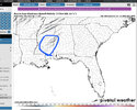
Gut says with this type of setup, go with this area to see the highest shot at a damaging tornado.Yep. Hard to punch low level mesocyclones down with that, the one that gets going gets going tho
Jefferson County is already on an e-learning day tomorrow, so I lucked out for my kids on that.Anyone heard anything about schools and the NWS discussing early school closings tomorrow?
By home ish

.png")