tennessee storm
Member
afraid look been buisy last hour with kids lol. did it go further north or something?Man, the 12z euro throws a kink into things ?. Don't know how to feel about it lol
afraid look been buisy last hour with kids lol. did it go further north or something?Man, the 12z euro throws a kink into things ?. Don't know how to feel about it lol
Just a good bit different, significantly less deep of a low and the euro shows the low traveling near the Memphis area northeast. Looks like its going to be Tennessee and south based on the new euro. Im going to throw the 12z euro run. way too different. Need to see another run or two with similarity. Can't look at a lot of other parameters because you have to pay so other than that idk.afraid look been buisy last hour with kids lol. did it go further north or something?
Can’t toss/throw it out considering it’s a pretty clear trend on the EPS/euro to a flatter look, given more northern stream trough interactionJust a good bit different, significantly less deep of a low and the euro shows the low traveling near the Memphis area northeast. Looks like its going to be Tennessee and south based on the new euro. Im going to throw the 12z euro run. way too different. Need to see another run or two with similarity. Can't look at a lot of other parameters because you have to pay so other than that idk.


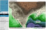
Has trended towards that look. Like to see a bit more consistency and a jump on board with the GFS for that solution to trust in it.Can’t toss/throw it out considering it’s a pretty clear trend on the EPS/euro to a flatter look, given more northern stream trough interaction View attachment 113452View attachment 113453


Definetly more riskier with the further south track like the euro shows. Better chance at breaking the cap and better shear further south overlapping the best moisture.12z euro actually lines up pretty well with the cips severe threat analog guidance, Almost to a tee. If I were a risky person I'd day that the 12z euro may be a bit more dangerous for the deep south than the earlier further north runs a bit more consolidated to south of the Tennessee border though. With this setup youll likely have a pretty dangerous storm or two riding near the warm front. View attachment 113461 View attachment 113456View attachment 113457View attachment 113458View attachment 113459
Keep up those trends and it will be a winter storm by verification time.Can’t toss/throw it out considering it’s a pretty clear trend on the EPS/euro to a flatter look, given more northern stream trough interaction View attachment 113452View attachment 113453
Flooding will be a big concern. See I agree with Huntsville with that, like the posts above if the low does track further south that actually increases the threat for the deep south because of higher instability meshed with higher shear. That Memphis area if the low tracks near there is prime position for most of Alabama and Mississippi for a decent weather outbreak.Huntsville AFD highlighting the same uncertainty discussed here in this thread.
“The biggest concern at this time with this system is locally heavy rain that could lead to flooding. PW values soar into the 1.5 to 2 inches range on Thursday, which is near observed maximum values for this time of year based on sounding from BMX. Severe storms are also possible. Yes, SPC has placed the area in a Day 6 outlook. However,
confidence is low at this time due to some timing uncertainties in the medium range guidance and whether or not all the parameters can
line up across the forecast area. Shear values are extremely strong, but as is often the case, the instability is lacking. This does not mean we will not see any severe storms, but with a system still 6
days out it is tough to determine specific details.”

Still believe cape will be able to make it in the 2000j range. But we will see. Euro paints a messy convective storm day. Still questions that we have to wait until mesoscale models get in range to really grasp on to anything.This is the nws of bham discussion View attachment 113470
Looks to me that GFS may be slowing the system down just a little.


.png")
I think on my posts above the nam is more volatile for our area. The upper level low may not shear out or as fast as the globals which leads to better height falls for the twin states. I've said many times I think this event has a high ceiling. The instability levels like they say that are higher today will continue to rise more and likely. I see the most likely threshold to be 2000j or so. Which is pretty good for a winter setup. You usually only see central Alabama and Mississippi reaching a max of 2500j in the winter time any any given setup.From Bham NWS afternoon discussion:
LONG TERM...
/Updated at 0238 PM CST Sun Feb 13 2022/
The overall battle of the models continue. While the main
forecast timing, albeit a touch slower, is still very close
with the system sliding through Midday and into the area,
instabilities values are higher this afternoon. Would expect this
to continue until we can get more of the higher resolution. The
overall synoptic pattern still showers a pretty good chance at
seeing severe weather across the the Southeast on Thursday. Trying
to get into the fine details is really too much at this time.
Bottom line is that we will see strong storms and moderate to
heavy rain. Severe storms will be possible especially with the
system sliding through during the afternoon.

Just no way to get around that warm layer though and with the monster moisture advection you are gonna have cloud cover.Sounding on the Mississippi Alabama state line. The LCL is basically almost scraping the ground with how low it is ?. I tell you when the Thermodynamics catch up. This is going to be a nasty setup. Still questions marks. BUT daytime arrival will alleviate some question marks if true. View attachment 113526
Yep, lapse rates are pretty meager still and the sounding just looks like grunge, looks like a Stratiform/elevated convection festJust no way to get around that warm layer though and with the monster moisture advection you are gonna have cloud cover.
This look alone makes me almost 100% sure most of AL will be socked in with clouds/showers, if not just rain. In this setup, you absolutely must have sunshine to get prefrontal convection and that likely still wont be enough.Yep, lapse rates are pretty meager still and the sounding just looks like grunge, looks like a Stratiform/elevated convection fest
Why would the nws bham be confident in tornadoes then? Cips analogs is also confident in a decent threat.This look alone makes me almost 100% sure most of AL will be socked in with clouds/showers, if not just rain. In this setup, you absolutely must have sunshine to get prefrontal convection and that likely still wont be enough.
Yep, fully saturated tropospheric soundings/poor tropospheric lapse rates and already present stratiform/elevated convection gives this setup a big reason to not be a big deal for AL/eastern miss. Also typically we shift the pseudo warm front south at go time vs modeled a few days before. Lots going against this setup, only area I could see being more interesting is the very southern sectionsThis look alone makes me almost 100% sure most of AL will be socked in with clouds/showers, if not just rain. In this setup, you absolutely must have sunshine to get prefrontal convection and that still may not be enough.
Definitely a chance of tornadoes with the front, but for a big pre-frontal threat, this isn't it. You can be confident in severe weather, but also be confident that unless something major changes it wont be a high end threat.Why would the nws bham be confident in tornadoes then? Cips analogs is also confident in a decent threat.
Yep, the gulf coast areas is normally the place to watch in these low laspe rate/high shear events. Those wind field shear/profiles are nasty.Yep, fully saturated tropospheric soundings/poor tropospheric lapse rates and already present stratiform/elevated convection gives this setup a big reason to not be a big deal for AL/eastern miss. Also typically we shift the pseudo warm front south at go time vs modeled a few days before. Lots going against this setup, only area I could see being more interesting is the very southern sections