Z
Zander98al
Guest
Need to watch this cell over the next couple hours. Very strong rotation can't exactly tell if it's superbroad though. 


First glance looks like a decent bow of straight line winds. More than likely a little rotation in there somewhere.
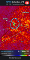
Shredded garbage.Talk about a messy slop storm mode, seen this from a mile away View attachment 113832


Winfield got hit last month, last thing they need is another one
 Memphis AL headed toward Carrollton
 Strong bowing north of Reform with high winds. Lightning picking up with this one too. Tornado over Carrollton, will know soon how bad it is or if still on ground.
Fox 6 thought they saw a debris signature but not sure if it is confirmed.


Pretty strong and tight rotation might be a quick strong touchdown. Unless if it stays on the ground for longerProbably about to get a quick touchdown on the northern cell. Velocity looks right.