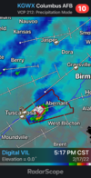
• Hello, please take a minute to check out our awesome content, contributed by the wonderful members of our community. We hope you'll add your own thoughts and opinions by making a free account!

Severe Severe Weather February 16th -18 2022

Big tornado upgrade! I was on to something I guess ?


Farther south, greater low-level theta-e advection suggests that the
boundary layer will become at least neutral, and therefore greater
certainty of surface- or near-surface-based storms exists -- both
near the advancing cold front, and also with associated warm
advection-driven bands of convection in the free warm sector. As
noted above, very strong shear -- with south-southwesterly 850 mb
winds in excess of 50 to 60 kt increasing to west-southwesterly at
70 to 90 kt at mid levels -- is suggestive of supercells, and
attendant risk for damaging winds and several -- and possibly
locally strong/damaging -- tornadoes. As such, an upgrade to
enhanced risk is being introduced, centered across the Tennessee
Valley area from late afternoon through the evening hours.


View attachment 113687
Can anybody tell me why they cut off the tornado risk at northwest Georgia?
 
Okay guys I like having the clown faces and all that stuff too. But continually just coming in here and spamming posts with them. Because you may not agree with something gets rather old. I'm putting my opinion out here on this setup. Yes probably isn't the most accurate always but doesn't mean it needs a clown or weinee for every post.
There just having the winter is leaving blues Zander. , it spring is approaching , just mater time long range all models ensembles
Big tornado upgrade! I was on to something I guess ?


Farther south, greater low-level theta-e advection suggests that the
boundary layer will become at least neutral, and therefore greater
certainty of surface- or near-surface-based storms exists -- both
near the advancing cold front, and also with associated warm
advection-driven bands of convection in the free warm sector. As
noted above, very strong shear -- with south-southwesterly 850 mb
winds in excess of 50 to 60 kt increasing to west-southwesterly at
70 to 90 kt at mid levels -- is suggestive of supercells, and
attendant risk for damaging winds and several -- and possibly
locally strong/damaging -- tornadoes. As such, an upgrade to
enhanced risk is being introduced, centered across the Tennessee
Valley area from late afternoon through the evening hours.


View attachment 113687
you the man Zander good call bud … u been staying with it man
 

Brad Travis WAFF 48 Meteorologist


The threat for strong winds is increasing for the area late Thursday afternoon into Thursday evening. We are declaring it a First Alert Weather Day due to the potential for winds 40-60 mph and a few brief low-end tornadoes. The wind will pick up ahead of the thunderstorms into the afternoon hours and most of the area will experience wind gusts 30-40 mph. A few areas could have isolated 60 mph winds with the storms ahead of the cold front (3pm-9pm). Isolated power outages will be possible along with some downed trees and tree limbs. The low-end tornado threat will develop within the line of storms as it tracks east. The tornado threat will be from brief spin-ups with 70-100 mph wind threat. The storm threat will wind down over DeKalb and Jackson counties around 9pm. Much cooler air will move in behind the front Thursday night. Afternoon highs will only be in the 40s Friday. It will be dry Friday through Sunday but rain showers will return next week
 
The wind is already picking up. Even if the main event so to speak doesn’t start to after 3pm, I wonder how schools will treat the wind threat. It appears that the wind will be high all day. The forecast discussion from HSV even mentioned a possible upgrade to high wind warning ? I wouldn’t think school systems would want buses running in 40-50 mph wind gusts before the storms even roll in. Just a thought.
 
One thing that always make me somewhat uneasy is being on the edge of a higher risk (enhanced) area. Memphis is on the western side of the enhanced outlook area currently. Wondering if the brunt of the activity will stay to the south and east?
 
The wind is already picking up. Even if the main event so to speak doesn’t start to after 3pm, I wonder how schools will treat the wind threat. It appears that the wind will be high all day. The forecast discussion from HSV even mentioned a possible upgrade to high wind warning ? I wouldn’t think school systems would want buses running in 40-50 mph wind gusts before the storms even roll in. Just a thought.
Probably going to have schools dismiss early tomorrow. The worst of the wind shouldnt get here until around the main time frame of the event I don't think
 
Call me crazy but there maybe a outside shot that a small moderate could be issued around the Alabama missippi state line. They wouldn't issue it until probably right before convection starts firing tommorow though.
 
Probably going to have schools dismiss early tomorrow. The worst of the wind shouldnt get here until around the main time frame of the event I don't think
Brad Travis just showed wind gusts at 35+mph at 10am with it going higher as the day goes on. Pretty sure we will be without power because our power grid sucks in Arab. Sigh
 
All I’m saying is, this isn’t screaming a mega tornado outbreak or Super Tuesday outbreak or a big one in general like I have been seeing hyped, esp on Twitter. but more so your classic wintertime setup that brings 1 or so strong tornadoes which form along a boundary and several weaker ones
Still liking this, especially in MS where crossovers/timing looks the best
 
Back
Top