BHS1975
Member
10/10 at the earliest
Sent from my SM-G975U using Tapatalk
Last year it was midway through fair week. It will probably be the same this year
Sent from my iPhone using Tapatalk
10/10 at the earliest
Sent from my SM-G975U using Tapatalk
103 here in Montgomery too
Crazy, easily the worst September of my lifetime, August 2007 type stuff.
Except its September. Very concerning trends lately. Cane season going into hyperdrive as well.
Sent from my iPhone using Tapatalk
Agreed! I'm convinced weather weenies like all of us are eternal pessimist... I've seen it before, some folks could be in the middle of a snowstorm and be complaining how it was going to torch with no more winter threats. Enjoy the moment my friends!As much as I want to ----- about all of the heat that is being forecasted, I can’t because I currently have 73 on the car thermometer #Blessed
Sent from my iPhone using Tapatalk
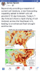
Rainfall deficits across the SE are definitely getting serious (I know y'all don't need to see this map to know that Lol)
View attachment 23686
Saves posts for mid 90s next weekAgreed! I'm convinced weather weenies like all of us are eternal pessimist... I've seen it before, some folks could be in the middle of a snowstorm and be complaining how it was going to torch with no more winter threats. Enjoy the moment my friends!
But at that time when temps are back in the mid 90's that's the time to complain Lol.... all I'm saying is don't let your disdain for what lies ahead steal your joy of the moment. (Hey that's pretty good right there)Saves posts for mid 90s next week
Sent from my SM-G975U using Tapatalk
Deep thoughtsBut at that time when temps are back in the mid 90's that's the time to complain Lol.... all I'm saying is don't let your disdain for what lies ahead still your joy of the moment. (Hey that's pretty good right there)
Rainfall deficits across the SE are definitely getting serious (I know y'all don't need to see this map to know that Lol)
View attachment 23686
Jack Handy! 25 degrees cooler right now, than yesterday at this time and .36 inches of rain last night! Winning!Deep thoughts
Sent from my SM-G975U using Tapatalk
Also apparently I don't the difference between steal and still............*facepalm*Deep thoughts
Sent from my SM-G975U using Tapatalk
From Maxar this morning:
"Summer continues in the Southeast, where numerous daily records have been broken of late. In Atlanta, daily records have been observed in five of the past eight days with highs in the mid-upper 90s, while record highs were observed in four of the past 10 days in Montgomery and three of the past six days in Macon. In fact, yesterday’s 103s in Montgomery and Macon were the hottest observed all summer. Heat relents after today across the region as high pressure arrives with easterly flow. However, another round of heat arrives next week. The 6-10 Day period features temperatures in the low 90s in Atlanta, Birmingham and Mobile, while mid-90s are forecast in Montgomery and Macon. The forecast is closest to the Euro EN but generally resides on the warm side of guidance. That said, there may still be hotter risk to the forecast given recent model performances in this pattern. Since the start of the month, max temperatures in Atlanta have averaged 5.0° warmer than the Euro EN and 9.5° warmer than the GFS EN in the 6-10 Day period, and the biases are significant in Birmingham (Euro EN by 2.2° and GFS EN by 6.9°), Montgomery (Euro EN by 3.7° and GFS EN by 7.0°), Macon (Euro EN by 4.4° and GFS EN by 9.3°) and Mobile (Euro EN by 4.2° and GFS EN by 6.4°) to name a few."
----------------------------------------------------------------------------------
This is not looking good for the SE: based on this ATL may easily get into the mid 90s for example!