Jessy89
Member
I wouldn’t be surprised to see the mountains of Pickens Greenville and Oconee counties get a Freezing rain advisory. Just a guess obviously
Yes you can...Should I change the topic to Possible Snow & Ice Threat Nov 14-15?

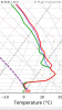
That's a sleet sounding as shown..... Since the atmosphere is solidly below freezing from the surface to the 850 layer, and a pronounced warm nose above that, it will most likely be sleet. Especially, if temps can manage -4C to -5C somewhere within in that cold layer.So how much of the sounding needs to be below freezing for sleet? If this wedge holds stronger and all of it is ZR, it will be really ugly. Euro seemed a bit warmer but not much. But light precip continues all afternoon and evening so I am worried about major issues with 1.5 qpf.
View attachment 7372
I believe we'll get the last laugh on the I-20 corridor Brent
You weren’t living in the big D, when they got like 12”, and were only supposed to get 1-2”?We better last year still haunts me we never got ours
 Looks like nw Alabama up into western Tennessee and then the western Carolinas are the winners on the 0z nam.
Yeah that 2 in. Strip going down MS/AL line is what the 12 and 18z gfs was trying to show as wellView attachment 7377 Looks like nw Alabama up into western Tennessee and then the western Carolinas are the winners on the 0z nam.
You are probably right, but if the CAD ends up stronger than modeled with lower dewpoints I could see the Northern CLT suburbs getting brief freezing rain before changing over.I doubt that north clt areas will get a glaze, bit we will probably see a brief period of sleet before it transitions to all rain due to dry air at around 875-925 mb before the onset
I figure places in western alabama will be added to the winter weather advisory in the morning. Also you hear the saying upper level lows bring weatherman woes. They tend to bring a few surprises with them also. So we will see. I hoping for a dusting where I am located. That would be a win for early in the season.Yeah that 2 in. Strip going down MS/AL line is what the 12 and 18z gfs was trying to show as well
This is what I’m hoping for. Lived here since 2006 and still haven’t had that big surprise snow that wasn’t supposed to be. This type of event definitely gives the best chance for a surprise.I figure places in western alabama will be added to the winter weather advisory in the morning. Also you hear the saying upper level lows bring weatherman woes. They tend to bring a few surprises with them also. So we will see. I hoping for a dusting where I am located. That would be a win for early in the season.

You weren’t living in the big D, when they got like 12”, and were only supposed to get 1-2”?
Would this be the earliest you have ever seen snow flurries ?I'm seeing a colder and wetter trend in the models tonight. Wrap around flurries is all I expect but maybe we can get a surprise too.
Not at all. Earliest accumulation I've seen was Nov 1 several years back at a dusting. Flurries I've seen in late October.Would this be the earliest you have ever seen snow flurries ?
Yeah and seems like the upper low is little further east as well.I'm seeing a colder and wetter trend in the models tonight. Wrap around flurries is all I expect but maybe we can get a surprise too.


45 and rain here. Temperature will be falling the rest of the dayBeautiful
Sent from my iPhone using Tapatalk


Crazy to me that it seems places in the deep south see snow every year before we see it here.
Mountains.Crazy to me that it seems places in the deep south see snow every year before we see it here.
I think it has a lot to with the fact that our early season cold air invasions drop down out of Canada into the middle of the country. We don’t benefit a whole lot from that type of HP placement. Just my amateur takeCrazy to me that it seems places in the deep south see snow every year before we see it here.
Btw I find this from the Rah NWS a little comical and even a touch of resentment that this storm is occurring now... LolMountains.
Deep south yes but also those areas are further west, as in west of the mountains (as RC noted), nothing to inhibit the cold air and further from Atlantic maritime influence.Crazy to me that it seems places in the deep south see snow every year before we see it here.
Why ?
Sent from my iPhone using Tapatalk