NBAcentel
Member
The soundings out of that 10% area the SPC is concerning, solid CAPE, but also, backing winds at the sfc, nasty wind profiles 
This. The soil is already drenched. We’re expecting 2-3” of additional rainfall. It won’t take much wind to uproot some trees.Don’t find this to be true ... winds could easily mix to the surface with any band of heavy rain .. forecasts gusts of 40-50 mph and even strong winds after the front moves by ... would expect many power outages from these type of winds with the amount of water that’s going to be in the ground

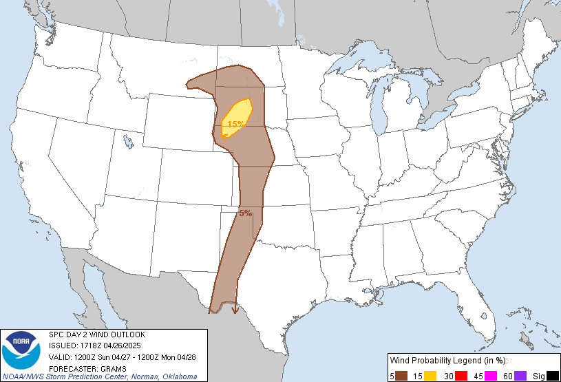
I agreeI definitely think it could, but dang, those wind profiles across Central AL and GA early are just nasty and quite discrete. Would probably constitute a moderate risk at least.
I said it before but wouldn’t be surprised if we see a MDT
From your area to mine to maybe CAEFor which areas?


You can definitely see the stronger storms hug the Gulf coast. GC stealing energy as always. I was waiting to see if it was going to happen and sure looks like it.
Sent from my iPhone using Tapatalk
I don't know about that... I always heard that most of the time is it has to be more of a squall line to steal moisture and energy. I could be wrong. Plus, it looks that that big area of rain is making its way N. Also, as large scale features move more north, I would imagine we'd see fewer storms over the FL peninsula.


Storm behind it just got a Tornado Warning too. Things starting to pick up now.Yep, it’s a confirmed tornado, CC isn’t lying


Might not. HRRR is also very ominousThe 18z NAM 3km really looked like it absolutely raked the southeast with severe squalls ... ominous to say the least but probably over done


Moderate for some areas. Maybe?Probably see it grow some more by the morning.....
WRAL met Mike Maze said the system should strengthen as it closes in on NC tomorrow. Sounds like it could actually get worse.

Mountains will break up the line and then it will reorganize in the piedmont as usual.
Sent from my iPhone using Tapatalk