whatalife
Moderator
I’ve started a December thread. https://southernwx.com/community/threads/december-2023.1239/


RAH has responded as well with forecasted temps. Some areas will probably fall into the teens. Here's my location:Looking at -10C at 850 on Wednesday which is honestly pretty impressive for late November

Record at rdu is 18, doubt it can get there with the UHI but the typically colder rural stations should hit thatLooking at -10C at 850 on Wednesday which is honestly pretty impressive for late November


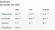
31.8F here, thats crazy you were all the way down to 23.23 this morning. With NWS saying 20 tonight I'm sure mid to upper teens is within reach with my terrain.

We were in the 20s by 8pm. If I moved my station down to the bottom of the hill I bet I could drop a good bit lower. I’ve had to change what I plant in the winter from the Emerson house just because of how we radiate. My garlic crop failed last year because of the cold.31.8F here, thats crazy you were all the way down to 23.
This is why you now being in zone 8A is a joke. I have way to much wind and a small amount of UBI to keep up with your lows.We were in the 20s by 8pm. If I moved my station down to the bottom of the hill I bet I could drop a good bit lower. I’ve had to change what I plant in the winter from the Emerson house just because of how we radiate. My garlic crop failed last year because of the cold.
I laughed when I saw that. If they are going to make the effort to update it they should do it on a more Micro scale.This is why you now being in zone 8A is a joke. I have way to much wind and a small amount of UBI to keep up with your lows.
They must really be banking on radiational cooling overperforming tonight. In the most updated model runs, the only model that I see being close to these temperatures is the Canadian, and it’s been running a few degrees too cold even for overnight lows. GSP has me with a low of 18 tonight, but every model except the Canadian has me between 22-25… even the short range modelsView attachment 138207
Are you all seeing this? NWS in Raleigh going crazy low with temperatures tonight across North Carolina...
View attachment 138209
This second push of cold air means business. Temps dropping during the day in Virginia. Its only 13 right now in western HIghland County and all the weather stations along the Blue Ridge are lo to mid 20s.They must really be banking on radiational cooling overperforming tonight. In the most updated model runs, the only model that I see being close to these temperatures is the Canadian, and it’s been running a few degrees too cold even for overnight lows. GSP has me with a low of 18 tonight, but every model except the Canadian has me between 22-25… even the short range models
Yeah, weird to see them so bullish on these lows. They are essentially forecasting a 35-40 degree drop in temps tonight.They must really be banking on radiational cooling overperforming tonight. In the most updated model runs, the only model that I see being close to these temperatures is the Canadian, and it’s been running a few degrees too cold even for overnight lows. GSP has me with a low of 18 tonight, but every model except the Canadian has me between 22-25… even the short range models
Yep. Multiple weather stations in the teens already north in Virginia.Boone topped out at 32 today. Currently 46 RDU as the drop begins across the state
")
and still really only model close to those numbers is the Canadian… GFS, HRRR, and Euro are low to mid 20s and 3kNAM is warmer than that. If it were just the GFS, you could see why not to put much weight on it with how it’s been running a few degrees warm of late, but Hi-Res models are fairly in line with it.Yeah, weird to see them so bullish on these lows. They are essentially forecasting a 35-40 degree drop in temps tonight.
RAH bumped up to 21 for RDU
Had a dusting this morning in BlacksburgCurrent radar echoes look interesting. Moving east/southeast. I don't expect anything to reach the ground, but it'll probably stay overcast through early afternoon over north/central NC.
View attachment 138212
Tonight, as the surface high slides over us, winds will become calm.
A few high clouds may stream in from the NW but otherwise optimal
radiational cooling should be in place for near-record lows (see
climate section) in the middle teens to lower 20s. We favored the
colder guidance given the anomalously cold airmass. Some outlying
areas could even dip into the lower teens as the NBM shows a 70-
percent probability of less than 10 deg F over portions of Randolph,
Chatham, and Moore counties.
Per the NWS in Raleigh..
Wow, you NC guys have all the fun!View attachment 138207
Are you all seeing this? NWS in Raleigh going crazy low with temperatures tonight across North Carolina...
View attachment 138209