accu35
Member
" Little or no snow accumulation expected. " MRX mets playing the house odds agains, and being pissy about it to boot.
Someone on the other board said the euro looked better for middle and eastern Tennessee. Anyone got maps? I have not renewed my subscription yet as I usually don’t until December. I might change that soon though.

") put you location in your profile? That gives us some idea of what or where you mean when things like, "looks good for me" etc.. are said in a thread?
put you location in your profile? That gives us some idea of what or where you mean when things like, "looks good for me" etc.. are said in a thread?
Agree. While I wouldn't completely rule it out either, it looks like the chances of seeing wet flakes or a brief change-over around the Triangle are very low. Maybe 5%.As a forecaster, I wouldn't bet on anything more than 1" in valleys of western NC and between 1-4" for mountain peaks above 4,000 feet. I think odds are too low that we see accumulation outside mountains into central NC so I wouldn't forecast it publicly. Can't rule out flurries for Triad to Triangle, though.
Yep. The only reason I'd even consider the possibility this time is how anomalous the incoming air mass is.Central NC folks DON"T fall for this. We will not see anything out of it. It is a classic cold chasing the moisture. It almost NEVER works out.
Central NC folks DON"T fall for this. We will not see anything out of it. It is a classic cold chasing the moisture. It almost NEVER works out.


I'll make sure to enjoy my 37 and rain. In all seriousness, this has been an interesting one to track, and I'm rooting for y'all elsewhereWhile its probably not as good as mesoscale models now, it’s worth noting how the gefs continues to bump up the mean, almost every ensemble member agrees on snow making it past the mountains View attachment 25806View attachment 25807
Just a reminder to fellow flatlanders though. It's best to plan a lot of extra driving time, and good tires, before making the trek out to any mountain community. Or maybe just plan on sticking around until it gets above freezing again.If anyone is wanting to chase snow this early I think the best place may be Gatlinburg.
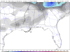
HRRR detecting bright banding already with that band of precipitation with a isothermal sounding, could see a heavy burst of wet snow if there’s that much lift/- omega inside the DGZ View attachment 25804View attachment 25805
When in doubt, sleet.
441 between Cherokee and Gatlinburg gets shut down more times than notJust a reminder to fellow flatlanders though. It's best to plan a lot of extra driving time, and good tires, before making the trek out to any mountain community. Or maybe just plan on sticking around until it gets above freezing again.
Hope it rains ?Temp has dropped from 49 to 46. Im growing impatient waiting on the cold/snow to arrive.
You are cruel !Hope it rains ?
Yes if I was going after it’s already started I’d take I-40 to the Sevierville exit and take that road in. If coming in from the NC side be careful, the Pigeon River Gorge can get tricky sometimes on I-40, even when it’s 70 and sunny.441 between Cherokee and Gatlinburg gets shut down more times than not
Wondering where you live, you’re account says Carrollton GA, but It’s in the 60’s there. I remember last year you being somewhere in Ohio Valley?Down to 39 at 2pm.
I am currently about 50 miles north of Cincinnati in SW Ohio.Wondering where you live, you’re account says Carrollton GA, but It’s in the 60’s there. I remember last year you being somewhere in Ohio Valley?
Sent from my iPhone using Tapatalk


Fairly decent increase for the triad on the 18z Hrrr.
12z
18z