RADAR is my favorite MESOSCALE model..Well looking at RADAR Trends.. Seems to bee filling in much more than many model outputs showed. IMO... Thoughts?
")
RADAR is my favorite MESOSCALE model..Well looking at RADAR Trends.. Seems to bee filling in much more than many model outputs showed. IMO... Thoughts?
Well looking at RADAR Trends.. Seems to bee filling in much more than many model outputs showed. IMO... Thoughts?
I'm starting to wonder if we get a lot of the heavy dandruff type snow here. Normally the radar has to be in clear air mode to detect the light nature of the precip as every bit of moisture is squeezed out. Will be hard for the models to figure out and could really create major problems with these temps. Watch for it.
I see the local Fox6 guys lowed their totals for the Bham area to 1/2" or less. Went completely against NWS raising theirs.I am guessing that’s kinda what Bham NWS is thinking too. I was shocked to read the discussion and then ramp things up so much. I hope they are right.
This storm is like 80-90 miles wide. Gonna come and go fast. Not much time to waste if it starts as rain. Not getting my hopes up here in Columbia.
Best outcome for us but unlikely at this timeLooking at the 03 SREF.. and going by the MBP2 (which generally is showing the highest amount of accumulation in the state of Alabama or at least near the top), you get these totals. Obviously just 1 member, but maybe if this storm over performs, it gives an idea at the possibilities. Blast away..
Florence/Muscle Shoals: 1.56"
North Huntsville (MDQ): 2.5"
Huntsville: 2.26"
Cullman: 2.05"
Ft Payne: 3.42"
Gadsden: 3.29"
Anniston: 3.33"
Birmingham: 2.47"
Tuscaloosa: 2.74"
Calera: 3.66"
Montgomery: 0.76"
Auburn: 1.83"
mmm, flurries....Smoke show weather babe Jennifer Valdez made no mention of the WWA on CBS 46. Showed the RPM. Just goes to show that no one has any idea on what’s going to happen with regard to how much redevelops, if any. She loves to say “flurries”.
Sent from my iPad using Tapatalk

.png")

mmm, flurries....
True but that pretty much brings it in line with all other guidance and it's .5-.75 amounts were probably way overdone up here, it's still .2-.4 with a bulls-eye over central NC up into south central Va.... solid 2-4" event with maybe a localized jackpot of 5-6Looks like the 6z ICON backed off quite a bit from earlier runs.
For NC most models continue to increase QPF totals ranging .3 - .5, as noted on here and Rah NWS stating it as well now possible 20:1 ratios... should quickly pile up.
Sent from my SM-G920V using Tapatalk
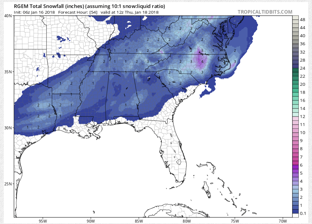
Has a small jackpot area just west of Durham up through Roxboro looks like of 5".... again I'm looking at QPF totals due to the possible insane 20:1 ratios, although the kuchera maps on pivotal should be closer to accurate but they could be underdone IF the total qpf is correct.RGEM looks great

You would really think they will learn their lesson but they don't.You would think that the largest TV market in the SE would have a better realistic approach to this, This is where Atlanta gets in trouble and it is the producers that are to blame, they tell them not to alarm or panic, lol, the public, then they get egg on their face later,,,
RGEM looks great
Temps do not appear to be an issue, the ICON still shows some issues at onset but it has a warm bias (so I've heard) and even Rah NWS not mentioning much about any mix to begin with, if so it will be a rapid change over to all sn and then quickly go to high ratiosWhat about temps?
Sent from my iPhone using Tapatalk
Nice map. If we truly get that jetstreak to form, could be super fun. LolHere's my forecast map. Pardon the quality, I just wanted to get something out this morning.
View attachment 3090
I thought under the streak, and just to the north, was where good precip would be occurring , but snowfall map doesn't reflect that?
The snow hole north of Atlanta is filling in, have faith!Sounds like we aren't getting anything unless we get a good trend. #DryAir. Good luck literally everyone else.