• Hello, please take a minute to check out our awesome content, contributed by the wonderful members of our community. We hope you'll add your own thoughts and opinions by making a free account!

Wintry More SE Snow ? (1/16-1/18)

Sooo Memphis...what are we gonna do?
 

Attachments

  • 47D07F7B-70EB-46FA-83F5-44E51F161314.jpeg
    47D07F7B-70EB-46FA-83F5-44E51F161314.jpeg
    189.1 KB · Views: 42
Birmingham will most likely be replaced with a winter weather advisory

Sent from my SM-J320VPP using Tapatalk
Yep I agree not sure why winter storm watch local met is saying only up to one inch lol
 
Yep I agree not sure why winter storm watch local met is saying only up to one inch lol
Even im their AFD they say snowfall amounts dont meet the winter storm watch criteria of 2 inches. But they keep talking about an enhanced snowfall band . just seems like 2014 is on their mind as they pound home the possible traffic impacts.

Sent from my SM-J320VPP using Tapatalk
 
URGENT - WINTER WEATHER MESSAGE
National Weather Service Memphis TN
438 AM CST Mon Jan 15 2018

...WINTER STORM TO IMPACT THE MID-SOUTH LATER...

.An arctic front will move through the Mid-South this afternoon
into this evening. Light snow will develop, first across very
northern parts of the Mid-South then shift south tonight into
Tuesday. Snow will intensify over East Central Arkansas, Northwest
Mississippi into much West Tennessee later tonight. Snow will
taper off from northwest to southeast on Tuesday. Arctic air will
rush into the region tonight and wind chills will drop to zero or
below across northern sections of the Mid-South.

ARZ049-058-MSZ001-002-007-008-010>013-020-021-152100-
/O.NEW.KMEG.WS.W.0002.180116T0300Z-180116T1800Z/
Lee AR-Phillips-DeSoto-Marshall-Tunica-Tate-Coahoma-Quitman-
Panola-Lafayette-Tallahatchie-Yalobusha-
Including the cities of Marianna, Helena, West Helena, Southaven,
Olive Branch, Holly Springs, Tunica, Senatobia, Clarksdale,
Marks, Batesville, Oxford, Charleston, Water Valley,
and Coffeeville
438 AM CST Mon Jan 15 2018

...WINTER STORM WARNING IN EFFECT FROM 9 PM THIS EVENING TO NOON
CST TUESDAY...

* WHAT...Moderate snow expected. Plan on difficult travel
conditions, including during the morning commute on Tuesday.
Total snow accumulations of 2 to 4 inches are expected.

* WHERE...Portions of East Arkansas and North Mississippi.

* WHEN...9 PM today to noon Tuesday.

* ADDITIONAL DETAILS...Be prepared for significant reductions in
visibility at times.

PRECAUTIONARY/PREPAREDNESS ACTIONS...

A Winter Storm Warning for snow means severe winter weather
conditions are expected. If you must travel, keep an extra
flashlight, food and water in your vehicle in case of an
emergency. The latest road conditions for the state you are
calling from can be obtained by calling 5 1 1.
 
Local Met forecast for HUN
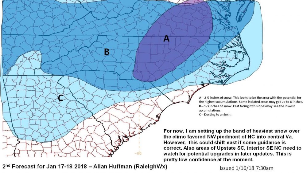
ce_snow-totals-contours.png
 
I know that Dave Toleris gets a lot of flack for his behavior on social media. However, he is a good meteorologist and puts out some quality blogs and videos. Here's his most recent video that outlines all of the ingredients and details to our system. It's worth watching to learn how all of the pieces come together. This was issued last night. The only drawback I see is that the models have backed off on the stronger closed low scenario for now.
 
Winter weather advisory for my area Winter storm warning for counties just to my west in NW MS. Congrats to them again
 
Looks like MEG went with 2-4 south of I40 and 1-2 north of I40. I think that's the right call atm. It has been a long time since we have had this setup. Usually these anafrontal systems over perform with an Arctic front. This will be the second time in 5 days we get powder. Still have 3 to 4 on the ground.
 
Last edited:
Like most if not all Deep South Winter events, this one will have some surprises...You can count on it

KBMX absolutely made the right call in going with a WSW
 
Last edited:
Interesting the CMC produced a closed off ULL and all the models trended away from it overnight. Technically the Euro still has it, briefly closing at 66hrs but opening back up and not closing until it’s too late (out to sea). I’ll continue harping on the fact that we need at least some sort of cutoff for Central NC and triad to overperform with this event. But I’m not saying we can’t have a decent snow over NC. Impacts also will be felt tenfold regardless, given the morning timing.
 
Last edited:
Birmingham will most likely be replaced with a winter weather advisory

Sent from my SM-J320VPP using Tapatalk
Yea. Kind of ridiculous to put out a WSW when zero guidance shows we will meet the criteria...HSV has it right with an advisory. May be able to remove that if qpf doesnt juice up.
 
Yea. Kind of ridiculous to put out a WSW when zero guidance shows we will meet the criteria...HSV has it right with an advisory. May be able to remove that if qpf doesnt juice up.
To be fair all the offices coordinated

Sent from my SM-J320VPP using Tapatalk
 
Back
Top